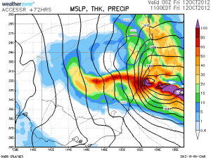
As you can see there is the potential of some heavy falls just north of Sydney and across the inland. With such cold air aloft, it is not surprising. As Jeff suggested in a text message this afternoon, the positioning of the low pressure system may drag some moisture inland.
Each run typically is intent on dragging cold air further inland and then across to the ranges. There is the potential for some significant snowfalls from this event.
Regards,
Jimmy Deguara















The GFS however has the rain over Sydney. Will check models in the morning.
What else is interesting is that ACCESS and GFS are both plotting completely different scenarios at the moment for thursday/friday. ACCESS is picking up an inland surface low which GFS is missing. If the BoM model is correct, we will be in for a really interesting few days. If GFS is correct it could be a bit of a let down.
The GFS however has the rain over Sydney. Will check models in the morning.
What else is interesting is that ACCESS and GFS are both plotting completely different scenarios at the moment for thursday/friday. ACCESS is picking up an inland surface low which GFS is missing. If the BoM model is correct, we will be in for a really interesting few days. If GFS is correct it could be a bit of a let down.