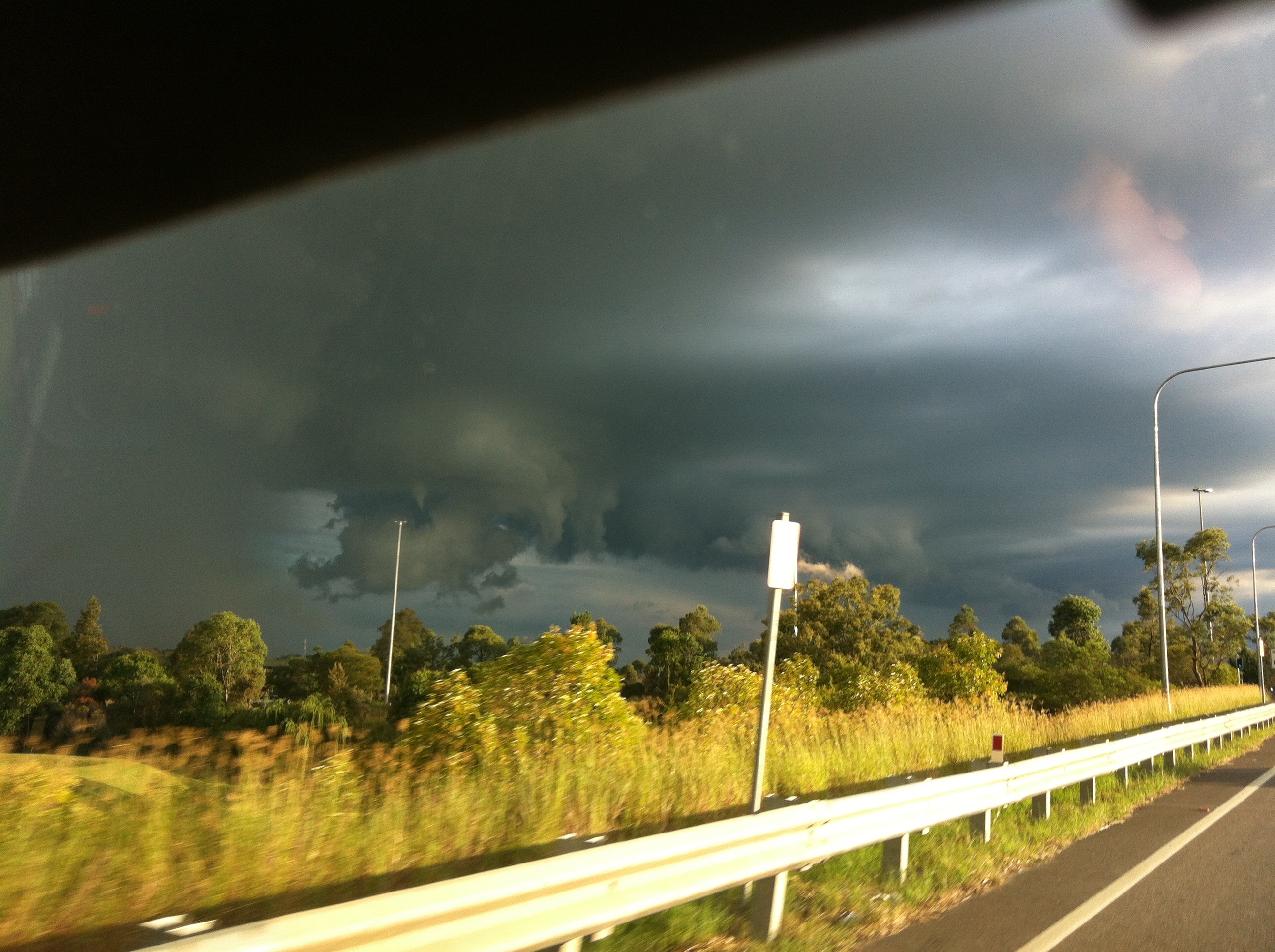
 Storms formed around Campbeltown this afternoon and tracked north Towards Penrith and St Marys. One of these cells intensified with a strong radar return or two before breaking down rapidly. Before it broke down though it produced a very well defined funnel cloud. At first I though the lowered areas were just scud but it appears some decent interaction was going on as a funnel appeared rapidly and I was even able to see it condensate before my eyes!

Thunderstorms · Tornado
Storms Western Sydney 7th of April 2013
More storms near Penrith, NSW
 Severe Hailstorms and Wind Luddenham 3rd October 2026
3 Oct 2026 · Sydney, NSW
Severe Hailstorms and Wind Luddenham 3rd October 2026
3 Oct 2026 · Sydney, NSW
 Hailstorms Western Sydney and Lower Blue Mountains
26 Sep 2026 · Sydney, NSW
Hailstorms Western Sydney and Lower Blue Mountains
26 Sep 2026 · Sydney, NSW
 First Storm and Hail Event for Season 2026-2027 – Western Sydney – Friday 25 September 2026
25 Sep 2026 · Doonside, NSW
First Storm and Hail Event for Season 2026-2027 – Western Sydney – Friday 25 September 2026
25 Sep 2026 · Doonside, NSW
 Warm Weekend with 30C Maximum Daytime Temperatures – Western Sydney 19 and 20 September 2026
20 Sep 2026 · Western Sydney, NSW
Warm Weekend with 30C Maximum Daytime Temperatures – Western Sydney 19 and 20 September 2026
20 Sep 2026 · Western Sydney, NSW
 A Week of Rain – Eastern New South Wales and Queensland – May 24 to 29
31 May 2026 · Eastern NSW
A Week of Rain – Eastern New South Wales and Queensland – May 24 to 29
31 May 2026 · Eastern NSW
 Storm Chase and Spectacular Thunderstorm Cell Camden NSW – Thursday 26 March 2026
27 Mar 2026 · Camden, NSW
Storm Chase and Spectacular Thunderstorm Cell Camden NSW – Thursday 26 March 2026
27 Mar 2026 · Camden, NSW
 Camden to Campbelltown Hailstorm 26th March 2026
26 Mar 2026 · Sydney, NSW
Camden to Campbelltown Hailstorm 26th March 2026
26 Mar 2026 · Sydney, NSW
 Significant Western Sydney Afternoon Thunderstorm with Large Hail – Saturday 21 March 2026
21 Mar 2026 · St Marys, NSW
Significant Western Sydney Afternoon Thunderstorm with Large Hail – Saturday 21 March 2026
21 Mar 2026 · St Marys, NSW
 Heavy Showers Cause Localised Flooding Across The Sydney Region – 18 and 19 March 2026
20 Mar 2026 · Sydney, NSW
Heavy Showers Cause Localised Flooding Across The Sydney Region – 18 and 19 March 2026
20 Mar 2026 · Sydney, NSW
 Intense Rainstorm / Thunderstorm Impacts Parts of Western Sydney – Hornsby to Horsley Park – Saturday Evening 7 March 2026
8 Mar 2026 · Horsley Park, NSW
Intense Rainstorm / Thunderstorm Impacts Parts of Western Sydney – Hornsby to Horsley Park – Saturday Evening 7 March 2026
8 Mar 2026 · Horsley Park, NSW
 Late thunderstorm Outer Western Sydney – Monday 9 February 2026
13 Feb 2026 · Outer Western Sydney, NSW
Late thunderstorm Outer Western Sydney – Monday 9 February 2026
13 Feb 2026 · Outer Western Sydney, NSW
 A Contrast of Two Storms Across Western Sydney – Saturday 31 January and Sunday 1 February 2026
6 Feb 2026 · Western Sydney, NSW
A Contrast of Two Storms Across Western Sydney – Saturday 31 January and Sunday 1 February 2026
6 Feb 2026 · Western Sydney, NSW
All storm reports from Penrith, NSW →
Also on 7 April
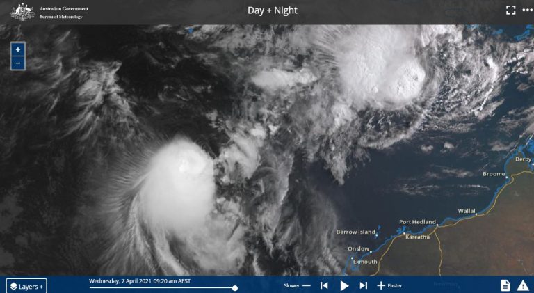 Two tropical storms off NW Western Australia – A rare event – 7 April 2021
7 Apr 2021 · Kalbarri, WA
Two tropical storms off NW Western Australia – A rare event – 7 April 2021
7 Apr 2021 · Kalbarri, WA
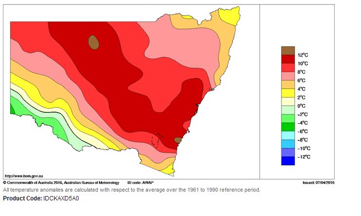 Unusual April heat SE Australia 5 and 6 April 2016
7 Apr 2016 · South East Australia
Unsettled weather pattern despite onshore flow
7 Apr 2008 · Northern Rivers, NSW
Unusual April heat SE Australia 5 and 6 April 2016
7 Apr 2016 · South East Australia
Unsettled weather pattern despite onshore flow
7 Apr 2008 · Northern Rivers, NSW
8 comments
Add a comment
You must be logged in to post a comment.
I was driving down the Northern Rd when the funnel appeared. This was from my mounted iPhone.
Another shot
And again
A shot of the storm later on when a nice rainbow appeared.
Big Rainbow at the end
Hi Jeff, nice imagery and definitely a base funnel there. I was looking SW at that feature when I went to pick Kimberly up from Blacktown. Interestingly, rain developed in the time I left Schofields and when I approached back via Quakers Hill, it was interesting to see how localised the rain was falling in one area whilst 200metres back it was almost dry! Then within 500 metres from there was run off in gutters! Rain with localised thunder persisted for at least 40 minutes or more.
Jeff, Penrith storm chasing have the same funnel zoomed on their website taken from someone in Glenmore Park.
Hi, Schofields got 17.6mm for this storm band yesterday which was not bad!