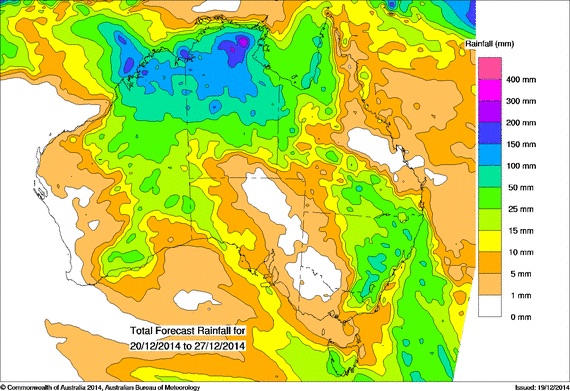
As we near the end of 2014, long awaited rainfall is forecast for many areas across Australia. The heaviest rain seems to be for the far north of Australia as the big wet gets underway. However, regions in southern, central and eastern NSW and also Western Australia can also get rainfall.
drought · Floods
Rainfall Forecast across Australia during the Christmas period 2014
More storms near Darwin, NT
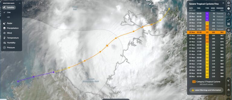
Tropical Cyclone Fina Moves away from Darwin – Sunday 23 November 2025
23 Nov 2025 · Darwin, NT
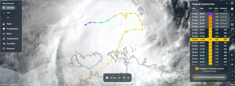
Tropical Cyclone Fina – Top End of the Northern Territory – Saturday 22 November 2025
22 Nov 2025 · Top End, NT
Strong monsoon low and possible tropical cyclone Top End NT 25/12/2015
25 Dec 2015 · Darwin, NT
Rainfall and Deficiencies January 2014
27 Jan 2014 · Howard Springs, NT
Tropical Cyclone development is possible for Northern Territory Sunday January 12 2014
6 Jan 2014 · Arafura Sea
Darwin Wet Season underway 28th to 29th October 2012
29 Oct 2012 · Darwin, NT
Darwin storm
25 Oct 2011 · Darwin, NT
Re: Darwin rumblings 2010/11
12 Mar 2011 · Darwin, NT
Re: Tropical Cyclone Carlos Darwin area – February 2011
18 Feb 2011 · Darwin, NT
Darwin drenched in record rainfall
16 Feb 2011 · Darwin, NT
Tropical Cyclone Carlos Darwin area – February 2011
15 Feb 2011 · Darwin, NT
Re: Does lightning strike twice in the same place
6 Feb 2011 · Darwin, NT
All storm reports from Darwin, NT →
Also on 20 December
Chasing fire tornadoes with Nick Moir – Central News
20 Dec 2023
Microburst Hits Northern Beaches 19th December 2021
20 Dec 2021 · Dee Why, NSW
Not much today given I had a tree blocking my quickest route up agter coming all the way from Moree to near Grafton. Then had redivert past the origin…
20 Dec 2020 · Grafton, NSW
Heavy rain, Floods, Storms and wind – NSW, QLD and NE Victoria – December 14 to December 19 2020
20 Dec 2020 · Eastern Australia floods (Coffs Harbour)
I am just wandering if the fire plume I photographed is the part that crossed the Warragamba Dam
20 Dec 2019 · Warragamba, NSW
One year ago today – an unprecedented hailstorm event hit Sydney! Upwards of 8 hailstorms up to 11 mostly supercells! 20th December 2018
20 Dec 2019 · Sydney, NSW
Historic Sydney Supercell Timelapse and Pictures 20th December 2018
20 Dec 2018 · Sydney, NSW
Heatwave grips southern Australia 20/12/2015
20 Dec 2015 · Sydney, NSW
Heat Wave Conditions December 2013
20 Dec 2013 · Hay, NSW
Storms N NSW 19th December 2012
20 Dec 2012 · Tenterfield, NSW
Microburst Hits Northern Beaches 19th December 2021
20 Dec 2021 · Dee Why, NSW
Not much today given I had a tree blocking my quickest route up agter coming all the way from Moree to near Grafton. Then had redivert past the origin…
20 Dec 2020 · Grafton, NSW
Heavy rain, Floods, Storms and wind – NSW, QLD and NE Victoria – December 14 to December 19 2020
20 Dec 2020 · Eastern Australia floods (Coffs Harbour)
I am just wandering if the fire plume I photographed is the part that crossed the Warragamba Dam
20 Dec 2019 · Warragamba, NSW
One year ago today – an unprecedented hailstorm event hit Sydney! Upwards of 8 hailstorms up to 11 mostly supercells! 20th December 2018
20 Dec 2019 · Sydney, NSW
Historic Sydney Supercell Timelapse and Pictures 20th December 2018
20 Dec 2018 · Sydney, NSW
Heatwave grips southern Australia 20/12/2015
20 Dec 2015 · Sydney, NSW
Heat Wave Conditions December 2013
20 Dec 2013 · Hay, NSW
Storms N NSW 19th December 2012
20 Dec 2012 · Tenterfield, NSW
1 comment
Add a comment
You must be logged in to post a comment.

A rainfall event has occurred across far North east New South Wales during this period that should be documented under this heading.
During the 27 December 2014, a small pocket of New South Wales experienced some very heavy rainfall. The area in question lies south from the New South Wales / Queensland state border and including the towns and cities of Murwillimbah and Tweed Heads. In descending order, the best totals include:-
Clothiers Creek – 299 mm (The highest total). I think this is a rural locality.
Tweed Heads – 292 mm.
Tweed Heads (Duranbah) – 291 mm.
Kingscliff Sewage Treatment Plant – 278 mm.
Banora – 239 mm.
Barneys Point – 214 mm.
Tumblegum – 198 mm.
Bilambil Heights – 192 mm.
Murwillimbah – 167 mm.
Coolangatta and Teranin Creek – 153 mm each.
Uki – 130 mm.
Dunoon – 125 mm.
The biggest totals are concentrated largely within the Tweed River Valley.
Much lighter falls have fallen further north, south and west. To show that in New South Wales, the following is noted:-
Evans Head 80.2 mm.
Yamba – 67 mm.
Ballina – 56.2 mm.
Grafton – 42.8 mm.
Coffs Harbour – 42.2 mm.
The totals are the 24 hours till 9 am 28/12/2014. The plot is attached to show the event for the region.