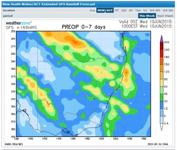
Longer range weather forecast models are suggesting some form of a rain event across Queensland, New South Wales and northern Victoria for the period 14 to 17 June 2015. Models are still inaccurate to the timing and amounts but indications are, much of the inland assuming the event unfolds would receive some useful rainfall totals.
The attached model from Weatherzone (GFS dated 10 June 2015) suggests the best falls to occur across the inland and outback Queensland, northern inland New South Wales and far south west New South Wales with many other centres receiving at least 15 to 30 mm. As suggested by the attached model (GFS), places like Mildura and Swan Hill (NW Victoria) and Armidale, Inverell and Moree (Northern New South Wales) would be receiving upwards of 50 mm. The attached model even suggests that an area across the inland southern Queensland could receive falls upwards of 100 mm.
Another model by the Bureau of Meteorology is suggesting a rain event towards the latter part of the period with much of New South Wales receiving at least 15 to 25 mm with higher totals across the inland south west slopes of the state.
Whatever occurs, such a widespread event would be useful. Given that an El Nino event has unfolded which can seriously reduce rainfall across eastern Australia, such an event would be beneficial for the cropping lands of the state as this would greatly assist farmers and provide much needed water where it is needed most.


Any storms expected?
Any storms expected?
Based on updated models, this event appears to provide the best rainfall across northern inland New South Wales and inland Southern Queensland. Given the developing drought situation, this event could be crucial to farmers in areas that badly need rain. As for thunderstorms, there is the forecast for rain and storms in some outback and more isolated areas of inland Queensland and models even suggest the possibility of some storm activity but it does not appear to be significant in extent.
Based on updated models, this event appears to provide the best rainfall across northern inland New South Wales and inland Southern Queensland. Given the developing drought situation, this event could be crucial to farmers in areas that badly need rain. As for thunderstorms, there is the forecast for rain and storms in some outback and more isolated areas of inland Queensland and models even suggest the possibility of some storm activity but it does not appear to be significant in extent.
I see a hailstorm over the interior which perhaps validates the comment of storms anticipated.
I see a hailstorm over the interior which perhaps validates the comment of storms anticipated.
Falls if 30mm expected in Sydney over a few day period possible!
Falls if 30mm expected in Sydney over a few day period possible!