Hi All,
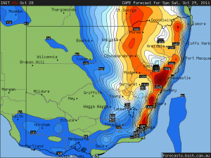 I’ve been plotting the models for this weekend and there is an interesting setup tomorrow down the South Coast around Moryua and Batemans Bay. Reasonable CAPE and Lifted Index focused along the surface wind change tomorrow afternoon. It’s a shame I can’t chase as I have never chased down the South Coast. Sunday the GFS model has the change around Forster/Taree with a similar setup. It’s not the best conditions though and I would hesitate to chase on Sunday. Weatherzone seems to be talking up Sunday with a forcast on their site of Severe Storms for NSW
Jeff.
18Z GFS CAPE Model predictions for 5pm local time





Hi,
Hmm, I just looked at the 00z GFS model for tomorrow which has just been released and If I get the chance I’ll be chasing down around the Lake Bathrust to Braidwood area. It will be frustrating though if good storms develop north of Braidwood and head into bush but further south there is the oppotunity to hase them down the Kings Hwy to Batemans Bay. Alternatively you could wait around Sussex Inlet for storms to come off the ranges. I was also thinking of the upper Hunter but the wind shear and moisture will probably be better down south and the Lifted Index is -5 with 1400 CAPE. Not a lot of CAPE but nice stron shear an when the change comes through you should see rapid strong storm development triggered. (hopefully ;-0)Jeff.
Sunday might be interesting to chase early afternoon storms that come off the Barrington area as the surface windchange should be there and combined with strong upper level shear there could be some interesting early storms on Sunday afternoon. What do you think?Jeff.
00z GFS has improved the chances for NE NSW on Sunday. It had looked like a tablelands day but would be a good chance for southern/western parts of Northern Rivers now. Still going for -10 at 500 hPa. Clarence Valley looks better at this stage.
MB
severe thunderstorm activity likely cenral N Island today.First of season D.pt 16 deg 22 deg, need more heat, send some over.!
Ok,
We checked the latest model data and OH NO! Upper level warning and surface lifted index around Sydney far less favourable. The only chance now is later action.
As you can see the 00Z run has shifted the main CAPE further north by about 500km. The upper level temperatures indicated a slight warming compared to the shortwave anticipated around the Sydney region.
Batemans Bay rarely gets any decent storms (and they don’t last; just had some hail before for about 15 minutes but it never turns into anything worth chasing), been watching the radar and it seems like the Newcastle-Taree area is the spot to be at the moment.