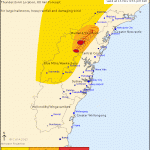
A couple of severe cells developed near Richmond and further both this afternoon with warnings issued for large hail, heavy rainfall and strong winds. A bowing segment seemed to occur earlier. Nice to see Sydney in on some action for a change!
More warnings are also current in Queensland this afternoon in regions near Brisbane and also to the north.

I got off work late this afternoon but to my delight was a couple of waterspouts offshore of Urunga visible as I drove home. I had to race home and grab the camera and luckily they were still going/new ones formed.
more:
I do not have any pictures but I was out late last night at Westpoint Blacktown watching two storm cells around 10 pm. One cell was over Sydneys North Shore and another around Windsor to the north west. It appears that these were intense cells containing heavy rain. There were smaller and weaker storm cells between the two. I was watching some nearby sheet lightning from Blacktown CBD.
I have had a brief look at rainfall figures for Sydney and noted an area west of Richmond and Windsor had 41 mm from the event and an area around Chatswood to Hornsby and parts of Sydneys north shore had over 50 to 70 mm of rain while other nearby areas missed out. Storms were certainly hit and miss. It is likely that there would have been some inundation and flash flooding around Sydney’s North Shore during the event given the rainfall that occurred..
At the same time, there was no significant activity across south and western Sydney.
Now that the detailed rainfall plots are available from the Bureau of Meteorology, it is noteworthy to show how significant last nights storm was. A significant storm traversed across Sydneys east dropping anywhere between 66 and 73 mm with 96 mm near Mona Vale. The path appears to have been narrow across the city and largely hit or miss.