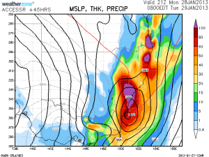
 Looks like the latest model upadte from the Bureau Access Model has now got extensive rainfall 28th to 29th January even as far down as Sydney! Well over 100mm of rainfall in the region now predicted.

3 thought on “Ex-Tropical Cyclone Low 28th 29th January 2013 Sydney and Central NSW”
Leave a Reply
You must be logged in to post a comment.
Paul Graham reports that if the ex-tropical cyclone hits Sydney, it will be the first time since 1950!
As it stands, the latest models suggest that the low will side-swipe Sydney. The Sydney region will get about 50 to 60 mm of rain which is much needed and definitely ease the very long and hot dry spell!
For those who are not familiar with the difference between an ex-tropical cyclone / tropical low and an east coast or polar low, the temperatures in the mid-levels are relatively warm. The map here shows temperatures in northern NSW fairly warm 0 to -2C compared to the approaching polar low (upper trough extension of the low) with temperatures of -14C and obviously colder approaching Victoria. For the position of the low, just refer to the wind barbs circulating the centre of the low in each case!