The period encompassing June 17 to June 22 for Southern and Eastern Australia is best described as being cold with below average daytime and nighttime temperatures occurring.
A feature of the winter solstice period for June 2024 is:
- A period of up to three nights where minimum temperatures plunged to below freezing at many inland centres across New South Wales.
- A rain event along the coastal strip of New South Wales which has seen moderate rainfall totals again across parts of Sydney.
- A lack of daytime heating around Sydney resulting in the maximum daytime temperature for Sydney (Observatory Hill) reaching 12C with other parts of Sydney struggling to reach 12C to 14C for Saturday 22 June.
During the mornings of the 18 to the 20 June, minimum overnight or early morning temperatures plunged to below zero for numerous centres across New South Wales with some very cold conditions occurring.
 reaching 12C with other parts of Sydney struggling to reach 12C to 14C for Saturday 22 June. During the mornings of the 17 to the 20 June, minimum overnight or early morning temperatures plunged to below zero for numerous centres across New South Wales with some very cold conditions occurring. While not record breaking, this event is the strongest burst of cold to affect the state so far for 2024. Cold minimum temperatures at selected locations are shown within the table below for the four day period 17 to the 20 June 2024 including commentary where needed. Locality 17 June 18 June 19 June 20 June Albury Minus 0.8C Minus 0.5C Minus 2.2C Minus 1.3C Armidale Minus 2.9C Minus 2.3C Badgerys Creek Minus 0.1C Bombala Minus 3.5C Minus 6.4C Cooma Minus 7.5C No record available but below freezing. Cooma Airport Minus 7.0C Minus 8.9C Lithgow Minus 2.5C Minus 1.0C Minus 3.3C Nerriga Minus 3.9C Minus 4.5C Richmond Minus 0.6C 0.0C A coastal rain event across Sydney and generally limited to the Sydney region during Saturday 22 June has seen moderate rainfall totals of at least 25 mm to 45 mm across coastal Sydney to 9 am Saturday with 55 mm falling at Sans Souci. Showers following this made for a cold Saturday with little heating occurring anywhere across the city. This is further backed up with falls of up to 59 mm across the coastal areas of Sydney to 8 am Sunday morning including 59 mm at Manly and 55 mm at Sans Souci with much lighter totals further inland. The front moving north along the south coast during Friday evening providing some light snowfall for the higher regions of New South Wales but there were no true heavy falls occurring. Currently the maximum snow depth is only 33 cm at Perisher but only across the highest elevations. A true winter snow outbreak is still required for this region. It is noteworthy that the strongest burst of winter cold for 2024 to date has occurred right at the time the winter solstice occurred making it a cold winter solstice period for many areas across southern Australia, The photos attached were taken 7 June 2012 near Canberra during a similar cold outbreak close to the winter solstice of that year and they show frost at sunrise. Similar mornings have again been occurring over recent days across the same regions and thus the scenes shown have again been replicated with frost being common place early mornings.")
While not record breaking, this event is the strongest burst of cold to affect the state so far for 2024. Cold minimum temperatures at selected locations are shown within the table below for the four day period 17 to the 20 June 2024 including commentary where needed.
| Locality | 17 June | 18 June | 19 June | 20 June |
| Albury | Minus 0.8C | Minus 0.5C | Minus 2.2C | Minus 1.3C |
| Armidale | Minus 2.9C | Minus 2.3C | ||
| Badgerys Creek | Minus 0.1C | |||
| Bombala | Minus 3.5C | Minus 6.4C | ||
| Cooma | Minus 7.5C | No record available but below freezing. | ||
| Cooma Airport | Minus 7.0C | Minus 8.9C | ||
| Lithgow | Minus 2.5C | Minus 1.0C | Minus 3.3C | |
| Nerriga | Minus 3.9C | Minus 4.5C | ||
| Richmond | Minus 0.6C | 0.0C |
A coastal rain event across Sydney and generally limited to the Sydney region during Saturday 22 June has seen moderate rainfall totals of at least 25 mm to 45 mm across coastal Sydney to 9 am Saturday with 55 mm falling at Sans Souci.
Showers following this made for a cold Saturday with little heating occurring anywhere across the city.
This is further backed up with falls of up to 59 mm across the coastal areas of Sydney to 8 am Sunday morning including 59 mm at Manly and 55 mm at Sans Souci with much lighter totals further inland.

The front moving north along the south coast during Friday evening providing some light snowfall for the higher regions of New South Wales but there were no true heavy falls occurring. Currently the maximum snow depth is only 33 cm at Perisher but only across the highest elevations. A true winter snow outbreak is still required for this region.
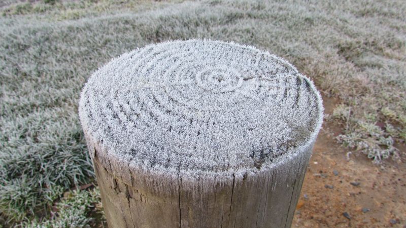
It is noteworthy that the strongest burst of winter cold for 2024 to date has occurred right at the time the winter solstice occurred making it a cold winter solstice period for many areas across southern Australia,
The photos attached were taken 7 June 2012 near Goulburn and Canberra during a similar cold outbreak close to the winter solstice of that year and they show frost at sunrise. Similar mornings have again been occurring over recent days across the same regions of the state and thus the scenes shown have again been replicated with frost being common place early mornings.