 Storms - Extreme Storm Discussion has posted a new item, 'Tropical Cyclone
Sandra 8th March 2013'
From the Early Warning Network
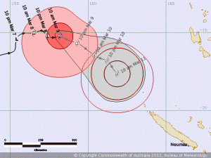
QLD Tropical Cyclone Sandra Forecast Track Variation
TROPICAL CYCLONE SANDRA - FORECAST TRACK VARIATION MAP
08 March 2013
Source: Early Warning Network
Tropical Cyclone Sandra was officially declared a Cyclone overnight and is
currently well off the QLD coast moving east. It is currently a Category 1
system.
Overnight there were some major changes to [...]
You may view the latest post at
http://www.extremestorms.com.au/2013/03/08/tropical-cyclone-sandra-8th-march-2013/

Trooical Cyclone Sandra has been upgraded to a Category 2 in the latest tropical cyclone advice.
Remarks:
TROPICAL CYCLONE SANDRA, CATEGORY 2, is situated over the eastern Coral and is moving gradually in an east to southeast direction. Tropical Cyclone Sandra is expected to continue to move in this direction over the next 36 hours while intensifying further. The system is then forecast to head south-southeast and weaken gradually in the following few days.
Tropical Cyclone Sandra currently poses no threat to the Australian coast.
Name: Tropical Cyclone Sandra
Details:
Time (EST) Intensity Category Latitude
(decimal deg.) Longitude
(decimal deg.) Estimated Position
Accuracy (km)
0hr 4 pm March 9 2 15.4S 158.8E 20
+6hr 10 pm March 9 3 15.6S 159.4E 60
+12hr 4 am March 10 3 16.0S 160.0E 80
+18hr 10 am March 10 4 16.4S 160.5E 105
+24hr 4 pm March 10 4 16.6S 160.9E 130
+36hr 4 am March 11 4 17.2S 161.7E 165
+48hr 4 pm March 11 4 18.2S 162.3E 200
The next Forecast Track Map will be issued by 11:00 pm EST Saturday