The passage of a strong winter cold front across southern Australia over recent days has brought rain, gale force winds and even some low level snowfall at certain locations.
The cold front crossed Victoria and New South Wales during Tuesday and into Wednesday and snow was reported at low levels outside the Snowy Mountains including but not limited to:
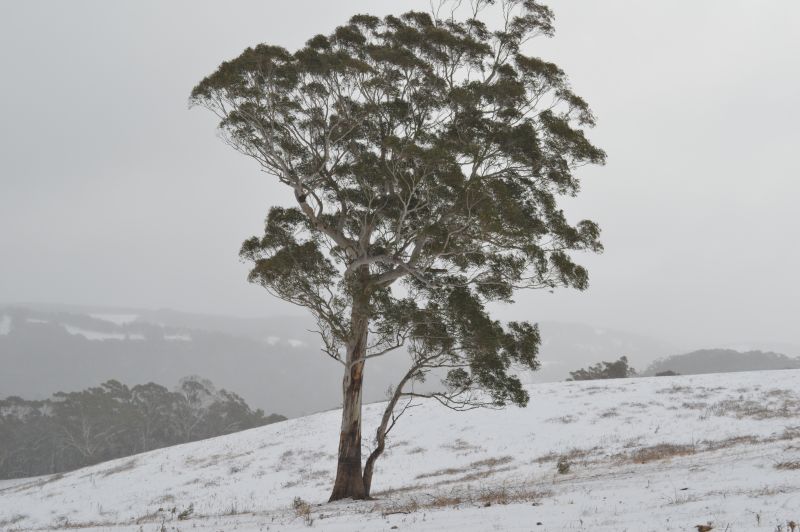
- Oberon region - Central Tablelands of New South Wales.
- Cooma - East of the Snowy Mountains.
- Stanley - South of Beechworth in Northeast Victoria.
Significant snowfalls fell at higher elevations at the usual locations which is typical of such events.
This was the second significant cold outbreak for the month of June but it is noted that the worst of the cold was limited to higher elevations.
For Sydney, the city was spared the worst of the cold but it was windy during most of Thursday. In particular:
Cold
No weather records were broken in terms of cold but some areas did experience colder than normal winter conditions including:
Orange (Central Tablelands of New South Wales)
- Wednesday 5.9C (Max) and 3.3C (Min).
- Thursday 7.2C (Max) and Minus 1.3C (Min).
Cooma (Monaro region)
It was not particularly cold during the event but it is noted that on Sunday 22 June, the minimum temperature fell to minus 10C early morning which is well below freezing.
Goulburn (Southern Tablelands)
- Wednesday 8.1C (Max) and 5.1C (Min).
- Thursday 10.3C (Max) and Minus 1.8C (Min).
- Friday morning, the overnight minimum fell to minus 6.2C as conditions settled down.
Wind
The highest wind gusts recorded Tuesday and Wednesday include:
- Mt Hotham (Northeast Victoria) - 130 km/h at 9.46 pm Tuesday night.
- Thredbo Top Station (New South Wales) 122 km/h on four occasions during Tuesday 24 June.
- Bellambi - 117 km/h at 9.02 am Wednesday morning.
In Sydney, wind gusts did peak between 50 and 85 km/h but wind gusts over 80 km/h were not too common.
Rain
The system did not produce heavy rainfall but some moderate and useful rainfall occurred including:
- Mt William - 37.8 mm to 9 am Wednesday morning.
- Casterton - 33.2 mm to 9 am Wednesday morning.
- Corryong and Wangaratta - 29.4 mm to 9 am Tuesday morning.
- Yarrawonga - 24.6 mm to 9 am Tuesday morning.
- Warrnambool - 22.8 mm to 9 am Wednesday morning.
Note: All locations are in Victoria where the best rainfalls fell.
While useful, the falls were not record breaking. Most other totals were much lighter for the event.
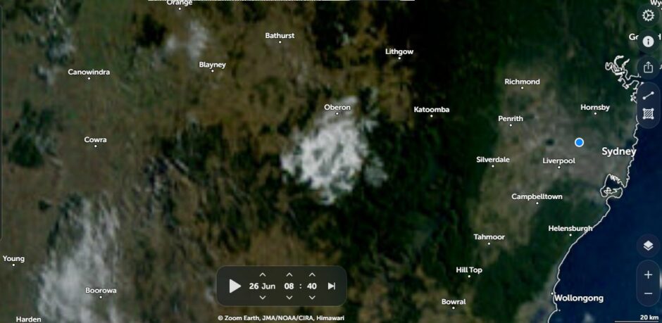
Attached to the post is the image of the Central Tablelands around Oberon Thursday morning showing snowfall that had fallen Wednesday night. The snow that fell across the Central Tablelands of New South Wales was limited to Oberon / Black Springs / Shooters Hill being the higher regions. (Source NASA Zoom Earth - Thursday 26 June 2025).
The snow has since melted and conditions have since eased but it is noted that a more significant winter coastal rain event is probable Tuesday to Thursday 1 to 3 July 2025 which has potential to produce 100 to 200 mm rainfall totals for the Sydney to Newcastle region in coming days. This event should it unfold would follow on the heels of the most recent cold outbreak that has occurred across the state.