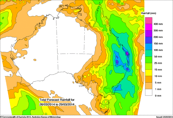
It seems very probable now that a major rain event is expected to impact the eastern states - particularly Queensland and NE NSW as well as to a certain extend other parts of eastern NSW. Rainfall totals in excess of 150mm can be expected in Queensland and possibly in parts of NE NSW over the next several days. Widespread falls 25 to 50mm in the previously drought affected areas are anticipated but probably not as likely in regions where it is most needed as a follow up. Northeast Victoria and northern Tasmania can also expect some some rain with lower totals generally.

Light showers this morning and heavy ocercast will make for some interesting rain event later!
Radar does look interesting once again with cells developing near Newcastle. A line exists off the coast with potentially heavy falls so we will see if it impacts Sydney.
Today it is the South Coast to feel the heavy rainfall event. Up untill 9 am 26/3/2014 substantial rainfall had occurred in an area south from Ulludulla all the way to Narooma including places like Batemans Bay and Moruya.
The heaviest falls during the period include 126 to 138 mm around Moruya, 120 mm at nearby Moruya Heads, 114 mm at Narooma and 112 mm at Barlows Bay.
Please find attached the rainfall plot for the South Coast focussing on the affected area.
In the 9 hours from 9 am 26/3/2014 to 6 pm 26/3/2014, the same area continues to experience heavy falls including 55 mm at Moruya, 65 mm at Bodalla and a fall of 87 mm at Belowra (ERTS) – most likely a locality.
During this period, there is substantial cloud across much of Eastern Australia producing varying rainfalls which is likely to continue.
Up until 9 am 27/3/2014, an extensive rainfall event has occurred across most of Eastern New South Wales. While the event is extensive, there are some regions that have been soaked while others have received light falls. In particular, the heaviest falls were concentrated in a small area of the state’s South Coast.
NSW South Coast:
Tathra 125 mm.
Barlows Bay 116 mm (Close to Narooma which only received 75 mm).
Eurobodalla 110 mm.
Bodalla 106 mm.
Merimbula 101 mm.
Are the heaviest falls.
When perusing the state of NSW, the Central West and North West fared quite well which includes:-
Central West Slopes
Geurie Post Office 61 mm.
Quandialla 53 mm.
Dudaman 50 mm.
Coonabarabran region from 42 mm to 52 mm.
North West Slopes
Mungindai 75 mm.
Mt Kaputar 73 mm.
Burren Junction 70 mm.
Mogil Mogil 65 mm.
Wee Waa 61 mm.
South West slopes
Rainfalls were much lighter and more patchy but some good falls to note include:-
Tocumwal 46 mm.
Narrandera 39 mm.
The Rock 38 mm.
Finley 35 mm.
There is an isolated fall of 82 mm at Perisher Valley.
The attached plot shows the rainfall distribution across NSW. It is a state of two halfs with the western areas missing out and little if any across the far north west.
Overnight 27/3/2014 and early morning 28/3/2014, an exceptional rain event has swept SE Queensland and NE NSW. Concentrating on the Richmond and Tweed River region, rainfall as high as 317 mm for the 24 hours to 9 am has occurred.
The highest total for NSW and the area was 317 mm at Boat Harbour (Which in theory represents an average of more than 13.2 mm per hour if averaged across the whole period).
Other impressive figures include:-
Couchy Creek 298 mm.
Uki 277 mm.
Murwillimbah 246 mm.
Mullimbimby (Chincogan) 240 mm (Must be a locality or farmstead).
Burringbar 237 mm.
Mullimbimby (Township) 206 mm.
Nimbin 153 mm.
These are substantial totals although I am not sure if major flooding has occurred or not. The plot shows the heaviest falls for the region.
Further to the above post, this event has also impacted South East Queensland including Gold Coast, Brisbane and the Sunshine Coast for the same period as shown in the plot below.
In South East Queensland, there is a fall of 319 mm at Lower Spring Creek Alert which is just inside Queensland from New South Wales. Other major falls include:-
Cooloolabin Dam 276 mm.
Mt Glorious Alert 216 mm and a nearby weather station recorded 230 mm. This is just to the north west of Brisbane.
Much of Brisbane city especially the western suburbs had more than 100 mm of rain up to 150 mm.
Again, I am unsure if this has caused significant flooding but some flooding would have occurred.