Extreme Storms

Rain

Rain event – South East Australia 12 to 14 February 2021

· by Harley Pearman

While not an extreme rain event, a significant rainband has crossed south east Australia over the past 3 days that has brought widespread rain to large areas.

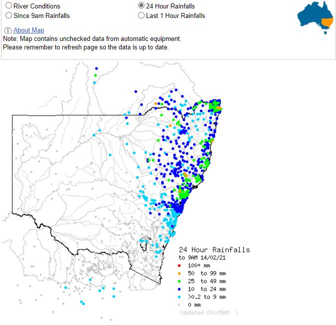
Widespread falls of between 25 mm and 50 mm with isolated heavier falls of above 50 mm has been a feature. Generally, the northern areas of the South West slopes, Central West New South Wales, Central Tablelands and the eastern areas of the plains (Wheat / Sheep belt) of New South Wales has benefitted the most.
This is the third or in some cases, the fourth major weather event within the past 3 weeks. While no major rivers are in flood, this rain is certainly reducing the effects of the most recent drought and generating runoff for dams and rivers.
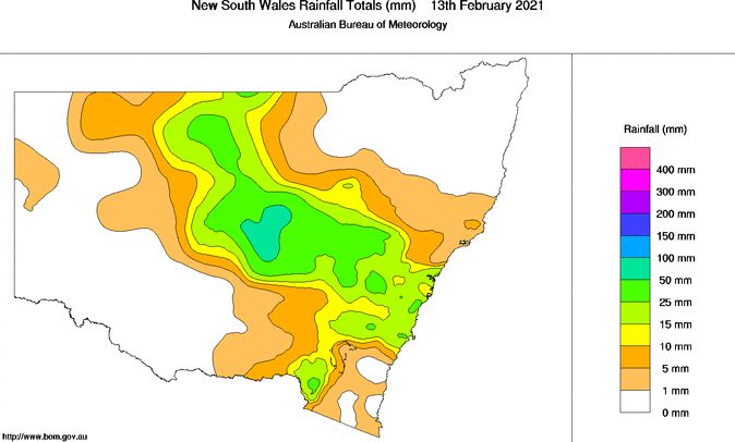
This event past over Victoria but produced only light showers generally between 1 and 5 mm. However, as it moved into the South West Slopes and Central West areas of New South Wales, rainfall totals increased dramatically due to more moisture being available.

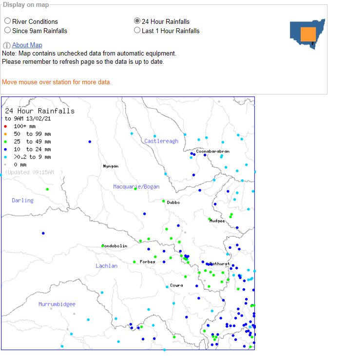
The heaviest totals include an isolated fall of 81 mm at Wollombi, south west of Cessnock, 67 mm at Barrington Tops, 59 mm at Barrington (Bonnie Doon Salisb) and 53 mm at Warialda. Large swathes of the New South Wales wheat sheep belt centred on Dubbo, Forbes, condobolin and Mudgee received between 25 mm and upwards of 50 mm from this event.
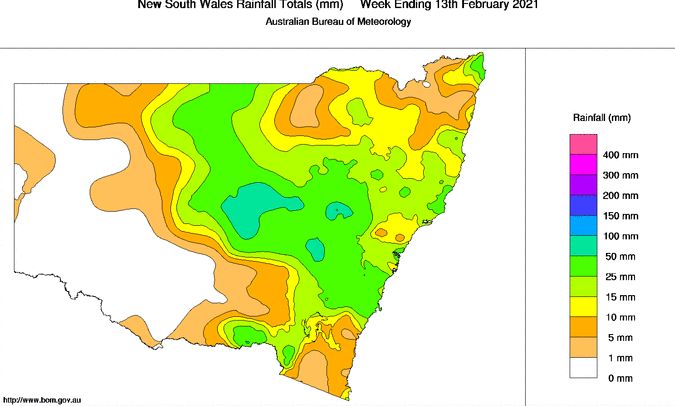
This event past over Sydney and produced widespread rainfalls within the range of 20 mm to 40 mm.

A number of rainfall plots produced from the Water and the Land for January and the start of February 2021 are showing how beneficial this rainfall and others have been.  There has been remarkable recovery across the Central West areas of the state, the lower north coast and to a lesser extent, the southern Murray region due to the events and the back up rain that is occurring.

As a result of this event plus other recent events, no part of New South Wales remains in drought.
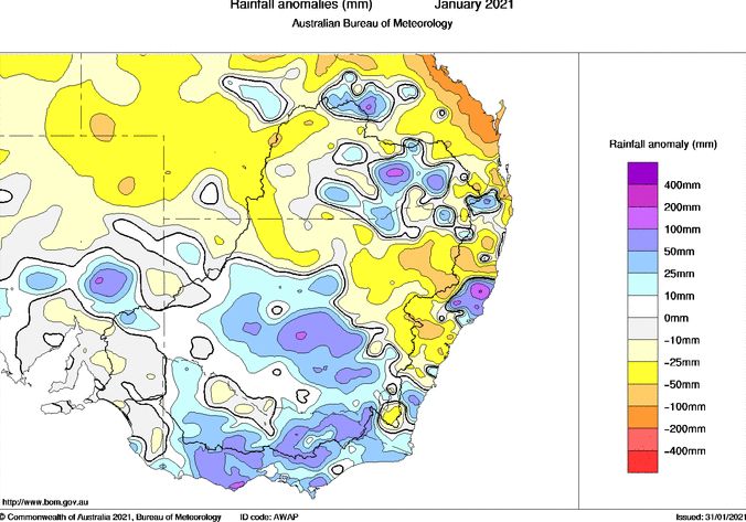
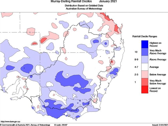
The plots attached to this post are generated from the Water and the land include the rainfall for the Central West areas of New South Wales, the rainfall plot for the 24 hours to 9am 13/2/2021, the rainfall plot for the 24 hours to 9 am 14/2/2021, the weekly rainfall plot for New South Wales and the monthly rainfall anomalies and deciles both of which show how significant the most recent rain events have been.
Open the storm map around Central West NSW rain

More storms near Central West NSW rain

Strong Thunderstorms and Storm Chase Central West New South Wales – Thursday 11 December 2025 12 Dec 2025 · Central West NSW Significant cold outbreak with low level snow NSW and Victoria – 24 and 25 June 2025 28 Jun 2025 · Oberon, NSW Can’t believe this was 7 years ago quite niceTo say I was expecting what we saw today I would be lying – fuzzy anvils and slow storm motions. We onl… 12 Feb 2023 · Lithgow, NSW On February 7th 2007 Dave Croan, Paul Graham and I ventured on a leisurely chase and targeted a triple point high instability play. We were greeted wi… 7 Feb 2023 · Bathurst, NSW Heavy rain and flooding New South Wales – Week ending 19 November 2022 20 Nov 2022 · Inland NSW floods Pulse Storms Central Tablelands 27th January 2020 Storms were anticipated with the model calculated capes of up to 2000J/kg but very weak wind shear… 28 Jan 2022 · Central Tablelands, NSW How long ago Another day another chase in 2019 with more hail and structure. The highlight for me and Tejay was being on the lookout at Mt Victoria w… 12 Jan 2022 · Blue Mountains, NSW One year ago beauty Started the day near Penrith and headed leisurely to Oberon. First storms of the day – one took shape and intensified. After gett… 27 Dec 2021 · Oberon, NSW I can’t believe this was a year ago already!! Nice storm I did a first timer chase near Jenolan (never chased this region) waiting for a line that d… 22 Nov 2021 · Jenolan, NSW Here are some pictures from the chase near Lithgow 17th November 2017. Some nice structure early from the storm that eventually did hammer the regio… 19 Nov 2021 · Lithgow, NSW Rain and storms continues into new year 1-3 January 2021 3 Jan 2021 · NSW rain and storms (Parkes) Started the day near Penrith and headed leisurely to Oberon. First storms of the day – one took shape and intensified. After getting hailed on (up to … 27 Dec 2020 · Oberon, NSW

All storm reports from Central West NSW rain →

Also on 14 February

After the storm Hail damage repair Hail dents removed from behind, factory paint kept. Hail Dent Repair.
Coming soon Radar and storm forecasting Live radar tools and severe storm forecasts from the Extreme Storms team.