Extreme Storms

Rain

Queensland, New South Wales and Victoria rain event 17 June 2015

· by Harley Pearman

Rainfall9am

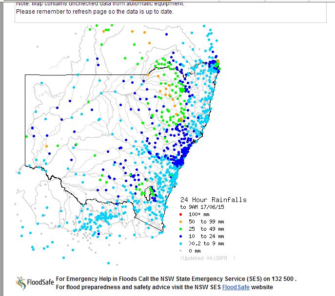
For the 24 hours till 9 am 17 June, a large swathe of Eastern inland Australia has received much needed rainfall with some reasonably large totals occurring. There are regions that have been dry and in drought but the regions are receiving worth while falls. This is not an event that will break any drought but it is significant as cropping lands are benefiting the most. The best falls for the period are:-

Far west New South Wales;

Broken Hill – 21 mm.
Burta – 30 mm.
Darlington Point – 36 mm.
Coleambally and Hillston – 37 mm.
Morundah – 38 mm.
Pooncarie – 71 mm (Highest in NSW).

A large area across the north west slopes and plains received falls ranging from 25 mm to 49 mm with the best falls occurring at:-

Caroda – 61 mm.
Nundle – 59 mm.
Terry Hie Hie – 55 mm.
Garah – 54 mm.
Mungindi – 52 mm.

Similar falls also occurred across the southern and south central inland of Queensland with the better falls occurring around Roma and Mitchell. The best falls include:-

Havelock – 63 mm.
Mictchell – 62 mm.
Southwood – 55 mm.
Roma – 53 mm.

Widespread falls of 25 to 49 mm occurred in this area.

During the period 9 am to 6 pm 17 June, further rainfall has occurred. A large area of cloud lingering across the south west slopes of New South Wales and North East Victoria has delivered worthwhile falls to the northern areas of North East Victoria including 30 mm at Hunters Hill, 15 mm at Albury while Wagga Wagga (NSW) collected 20 mm during this period. Most areas within this region collected at least 10 to 20 mm from the cloud mass during the period.

The rainfall plot from the Bureau of Meteorology (Water and the Land) is provided and dated 17/6/2015.
Open the storm map around Eastern Australia

More storms near Eastern Australia

Storm Chase Sydney to Mudgee and Merriwa – Includes Eastern New South Wales Storm Outbreak Saturday 15 November 2025 16 Nov 2025 · Mudgee, NSW Last major hot spell and inland heatwave for spring / summer 2022/2023 NSW – 16 to 20 March 2023 25 Mar 2023 · Inland NSW On the 28th and 29th December, I headed out chasing up and including the NW Slopes and Plains. Storms went up early on both days but it was the late … 31 Dec 2022 · Dunedoo, NSW Really enjoyed this! Certainly made for a great end to the day The chase yesterday 13th March 2017 was a decent result for what could have been a fai… 5 Jul 2022 · Dunedoo, NSW Quite a great end to the day Ok a couple of weeks back but here are video stills from that colourful supercell – this was the Mendooran supercell 18 Mar 2022 · Mendooran, NSW Just insane contrast and colours Ok it has been some time since I did proper editing. This is the Mendooran storm with Rodney. 26 Feb 2022 · Mendooran, NSW Pulse Storms Central Tablelands 27th January 2020 Storms were anticipated with the model calculated capes of up to 2000J/kg but very weak wind shear… 28 Jan 2022 · Mudgee, NSW 1 year ago this happened On the 28th and 29th December, I headed out chasing up and including the NW Slopes and Plains. Storms went up early on both … 31 Dec 2021 · Dunedoo, NSW Same supercell day Nevertire A few video stills from yesterday big storm! Given the barrage here, there were a few close bolts. In one case, I saw a … 21 Nov 2021 · Nevertire, NSW Not so long ago. Check out some Mendooran lightning last Friday during a 5 minute lightning barrage #lightning #storm #photography StormHour Reed Tim… 2 Nov 2021 · Mendooran, NSW Tornado tears through Central West of NSW, leaving 30km trail of destruction 30 Sep 2021 · Armatree, NSW Probable rain and storm event Inland NSW 29 – 30 September and 1 October 2021 25 Sep 2021 · Inland NSW (Central West)

All storm reports from Eastern Australia →

Also on 17 June

2 comments

Add a comment

After the storm Hail damage repair Hail dents removed from behind, factory paint kept. Hail Dent Repair. Chase with us Chase a storm for real Guided storm chasing tours in Australia and Tornado Alley. See Thunderbolt Tours.
Coming soon Radar and storm forecasting Live radar tools and severe storm forecasts from the Extreme Storms team.