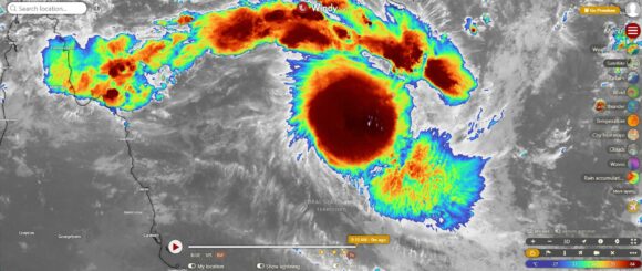
A tropical cyclone is expected to form off the Queensland Coast, well east of Townsville and Cairns over the coming hours. The general consensus of various weather models is that initially, the system will track east away from the coast then turn and head south.
The storm is expected to be slow moving but the primary issues of this storm is that no weather model is in agreement of where the storm may go after Thursday. In this regard, models vary widely in relation to forecast tracks and how conditions will play out.
The primary image attached to this post is from Zoom Earth - NASA Sunday morning February 23 2025. The image suggests a storm reaching at least Category 3 under the Australian Tropical Cyclone Intensity Scale which would be equivalent to a Category 2 storm system under the Saffir Simpson Scale with peak winds at the core of 155 km/h based on current projections.
It is becoming clear that peak intensity will occur when the storm is out to sea with weakening occurring thereafter and later in the forecast period.
Weather models are confusing in relation to where the storm may go. Using windy.com and projecting out as far as feasible, it is shown that:
ECMWF - The model has the storm forming, then tracking south and later turning southwest towards the Queensland Coast and Yeppoon / Rockhampton but still remaining offshore. The storm then turns and tracks south to be near Norfolk Island by March 7. In this regard, no landfall would occur but a rain event would impact a large portion of the southern Queensland coastline especially between Rockhampton and Bundaberg. The storm then turns and tracks southeast away from Australia to die out over open water.
GFS - This is interesting as the model suggests a storm much closer to the coast but weakening towards Rockhampton. The storm then hugs the coastline as it makes its way south. The model suggest a storm tracking south to be an ex tropical cyclone off the New South Wales coastline and Bryon Bay by early March. This suggests a storm traveling direct south. This would deliver a high rainfall event along the New South Wales coastline for early March and such an event would even reach Sydney at some point.
ACCESS - The model keeps the storm well offshore having minimal impact to any part of Australia.
ICON - The model has the storm weakening halfway between Australia and New Caledonia which appears to be the least likely scenario for the storm.
As shown, there are various scenarios at play over coming days in relation to the storm. This is certainly an interesting storm that ought to be watched especially given that various outcomes are anticipated and with no consensus of what may occur.
This storm will be watched to see what occurs.

I have attached an infrared image of the storm showing a near circular storm. A lightning tracker is added showing lightning across part of the storm. Sunday morning, the storm appears to be at a point where it is transitioning to a tropical cyclone.
