A major snowstorm has impacted a large region of northern New York state over recent days known as a “Lake Effect” snowstorm. In particular, the small town of Palermo in Oswego County has experienced 3 metres of snowfall since February 1 2025 with 2 metres of snow falling between Friday 14 February and Thursday 20 February 2025.
So much snow has fallen that residents have become trapped within their homes.
Palermo has a population of approximately 3,460 and most residents are unable to move about due to the amount of snow that has fallen.
House roofs are creaking under the weight of the snow and all roads to and from town are impassible.
Following the storm, emergency services have been struggling to clear paths through the snow and local residents have been struggling.
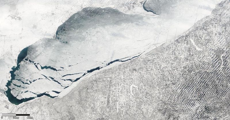
The whole region is impacted and satellite photos clearly shows that a wide region is impacted. Indeed, large amounts of ice is visible within Lake Erie and the lake edges are frozen.

Such snowstorms occur more regularly than many would realize. An extreme and similar event struck close to the region during the winter of 1976 / 1977. During this particular event, the city of Buffalo (Upper New York state) which usually suffers from extreme cold and snows experienced an event that totally paralyzed the city.
The city lies at the western edge of the state and at the head of Lake Erie.
By January 28 1977 within Buffalo City, snow had fallen for 40 days in a row and a thick blanket of up to 1 metre in depth carpeted much of the city region. This was followed by a major snowstorm. The storm resulted in 17,000 residents being trapped in city centre offices with many more being trapped in factories across the city.
Thousands of drivers could not move and the city ground to a halt. Intense lake effect snow fell for 3 days and following the storm, snow drifts reached almost 9 metres in depth in places.
A natural disaster was declared across the affected region. The final death toll was 29 including 9 who died in their cars trapped on freeways and other roads. The snow storm of late January and early February 1977 still stands as a benchmark in terms of storm severity for the city.
It was so cold that even parts of Niagara Falls froze over and that in itself is extremely rare.
There has since been much research into such weather events. Research has shown that in early winter, the lakes are still relatively warm from the summer. The first cold winds of winter blow over the lakes drawing moisture from the surface of the water body. The winds then blow onto the land. Clouds form and the moisture falls as snow. Usually, the heavier snows fall slightly inland away from the edge of the lake.

Further the winds blowing along the lakes have unrestricted reach due to lack of hills across the region.
The winds can blow over the same area for days resulting in a train echo effect or training where snowstorm after snowstorm will affect the same area until dislodged by another weather system. Often on either side of the snowstorms, it could be fine and even sunny but cold. Heavy snow can accumulate rapidly in locations affected by the training snow storms.
The lake effect snows only weakens once the lake or lakes of the region have lost all their available heat.
As such, lake effect snows occur just about every year across the region. It is possible for snow accumulations to reach 10 cm per hour.
In additional to the event of 1977 and 2025 which are well documented, other sizeable and disruptive lake effect snowstorms across the region include but not limited to:
- December / January 1999 - Upper New York State.
- February 2007 - Regions east of Lake Ontario heavily impacted.
- December 2001 (Called the Bald Eagle event) where 207 cm of snow fell over Buffalo city between December 25 and December 31.
- October 2006 Buffalo City (Early season lake effect snowstorm).
As previously mentioned, the lake effects snowstorms occur every year but some such as the Palermo event of February 2025 stand out amongst all other snowstorms.
Attached are satellite photos of the region following the most recent lake effect event which has resulted in very high accumulations of snow.
I have also located an image of Buffalo City taken 1977 (Black and white) - The Buffalo News (Photo shutterstock images - Thursday 27 February 2025). This shows what the lake effect snows are capable of in terms of snow impacts and depth. Such scenes are repeated over and over again including what has occurred at Palermo.

A map of the affected region has been prepared showing the location of Palermo and Buffalo, the subject of this article.

Source material used for the primary discussion
1- Planet Earth - Storm (The Blizzard that buried Buffalo) Pages 60 - 65, ABC Whipple (1982).
2 - Extreme Weather Pages 52 - 54, H Michael Mogil (2007).