http://www.extremestorms.com.au/strong-cold-front-rain-wind-snow-and-cold-weather-southern-australia-1-11-june-2022/
June 2022 - A break in the rainfall for Eastern Australia
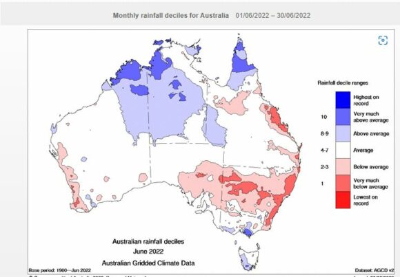
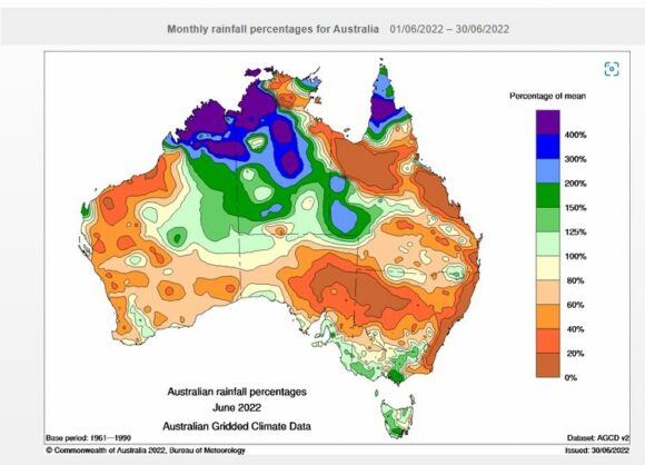
The month of June 2022 provided a break in the rain and for most areas, there were no significant or damaging weather events.
It is noted that the month of June started out cold and wet especially across southern areas of the country. Generally, the only significant event was the cold outbreak that heralded in the start of the month. The event is covered in detail at “Strong cold front / rain / wind / and cold weather Southern Australia 1 - 11 June 2022”.
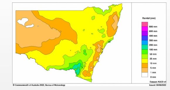
Rainfall totals across coastal regions were relatively light for the month and across much of Sydney, rainfall was well below average. This provided the opportunity for river catchments to begin to dry out.
As shown in the table below which is updated from the table of May 2022 for the same New South Wales localities, rainfall across coastal centres is still impressive despite the month being dry. Already, there are weather stations and towns that have received more than 2,000 mm for the January to June period.
Table showing rainfall for selected localities
| SYDNEY REGION | June 2022 | So far for 2022 |
| Parramatta | 2.8 mm on 6 days. | 1,196.8 mm |
| Penrith | 2 mm on 8 days | 1,107.8 mm |
| Richmond | 2.4 mm on 6 days | 1,005.2 mm |
| Sydney (Observatory Hill) | 16.8 mm on 6 days | 1,538.4 mm |
| Home (Comparison and guide only) | 2.3 mm on 5 days | 1,065.3 mm |
| NORTH COAST NSW | ||
| Ballina | 27.8 mm on 7 days. | 2,083 mm |
| Coffs Harbour | 2.4 mm on 3 days | 1,807 mm |
| Dorrigo | 2.6 mm on 2 days. | 2,037.5 mm |
| Grafton | 3.8 mm on 2 days. | 1,120.6 mm |
| Port Macquarie | 8.6 mm on 3 days | 1,609.2 mm |
| WHEAT SHEEP BELT NSW | ||
| Albury Airport | 72.8 mm on 19 days | 560.8 mm |
| Dubbo | 12.8 mm on 6 days | 507,2 mm |
| Forbes | 12.6 mm on 10 days | 420.6 mm |
| Tamworth | 23,8 mm on 6 days | 378.2 mm |
| Wagga Wagga | 43,8 mm on 19 days | 333.8 mm |
During the month, the La Nina event driver contributing to the high rainfall was formerly declared over however, there are still significant concerns that the La Nina event may reappear later in the year for a third year running which if it occurs, would be rare.
A La Nina watch for 2022/2023 has already been issued.
Of interest, the Indian Ocean Dipole is now in negative which should augment rainfall across large parts of Australia and the Murray Darling Basin. This is being shown by the major rain event presently occurring across some coastal regions which is being covered in separate posts.
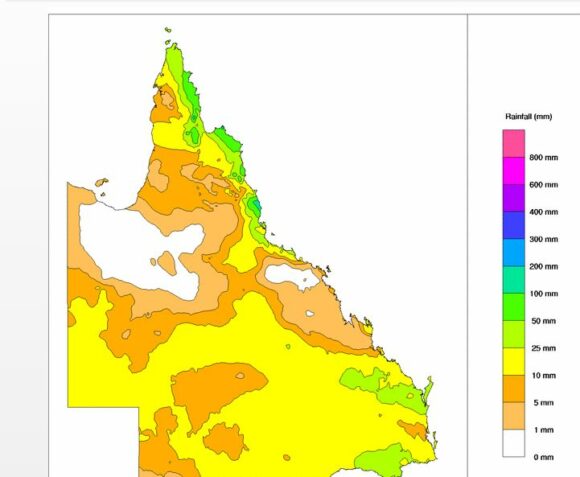
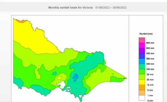
Attached are relevant Water and the Land Plots showing the rainfall for June 2022 with some interesting outcomes. Of particular interest:
- Much of Australia was relatively dry for the month.
- Victoria - North East Victoria was relatively wet due to regular frontal systems providing rainfall and snowfall at higher elevations.
- Due to regular bursts of westerly winds, coastal New South Wales was dry.
Of note, a major rain and flood event has occurred at the beginning of July 2022 across coastal New South Wales but this event is covered in separate posts. The cumulative rainfall totals resulting from the event will be added to the July totals early August.
Notes
1 - All rainfall and historical rainfall used is sourced from BOM historic data and data from official weather stations.
2 - While I have a rain gauge set up in the rear yard, it is only being used as a guide but it is noted that it is relatively consistent with official figures occurring at nearby Prospect and Horsley Park where official weather stations are established.
