https://www.extremestorms.com.au/queensland-rainfall-and-floods-march-24-to-march-29-2025/
The attached images are probably the best method available to show the true scale of the inland flooding that is currently affecting the inland southwest of Queensland and parts of outback New South Wales (northwestern areas).
The Channel country flooding following two recent rain events covers a vast swath of the region and it is estimated that such flooding will continue for weeks to come. The area is low lying and as such, floodwaters are slow moving.
It is estimated that cattle losses to date tops 150,000 plus an area twice the size of Victoria is impacted.
The Landsat 8 showing the Copper Creek near Windorah (Feature image) taken by NASA on Saturday 29 March shows the true extent of the flood. Flood waters have risen to levels higher than that of 1974.
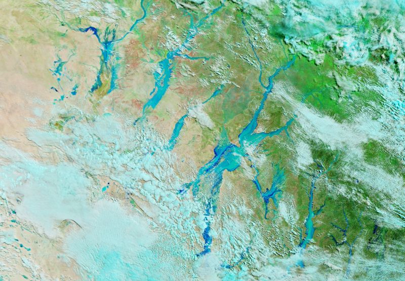
The same day, the image shown taken by MODIS on the TERRA satellite shows the extent of flooding more clearly. What roads that do exist are cut and isolated properties are further isolated.

The small town of Thargomindah has been hit particularly hard with evacuations in place.
It is fortunate that such flooding is occurring mostly across remote and isolated regions of the outback.
The waters are flowing slowly towards Lake Eyre. In time to come, this event will promote the growth of grasses and provide temporary breeding opportunities for wildlife. Eventually the water will evaporate and thus the cycle of droughts and floods will continue.
Both images are via NASA (Image of the Day March 29 2025).