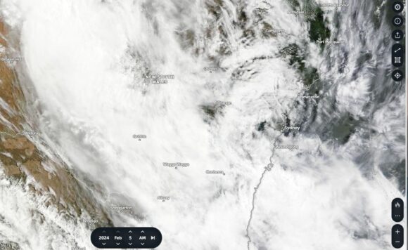
During a 2 day period between Sunday afternoon and Tuesday morning, a significant rain event crossed over large parts of New South Wales.
Originating from Queensland and from ex tropical cyclone Kirrily, the event first passed over North West New South Wales then tracked south east crossing the coast between Newcastle (North) and Batemans Bay (South).
Most localities within a narrow path spanning 300 to 400 km wide received a significant rain event while any town or locality outside the path largely missed out and received little or no rainfall.
As such, north east New South Wales and south west New South Wales mostly avoided the event.
There were thunderstorms within the cloud mass and for the first time in over a month, rumbles of thunder were briefly heard as it passed over Western Sydney early Tuesday morning between 4.20 am and 7 am. While a handful of minor rumbles of thunder were heard, this was not significant in itself with the main feature being a period of moderate to heavy rainfall. The event started to clear out to sea by daybreak and sunrise.

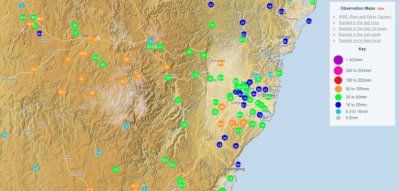
During a 3 hour period, there were widespread 25 to 50 mm falls across Sydney. Generally, for localities further north of Sydney, rainfall decreased. The heaviest falls occurred at Kentlyn where 61 mm fell while Mossman received just 12 mm.
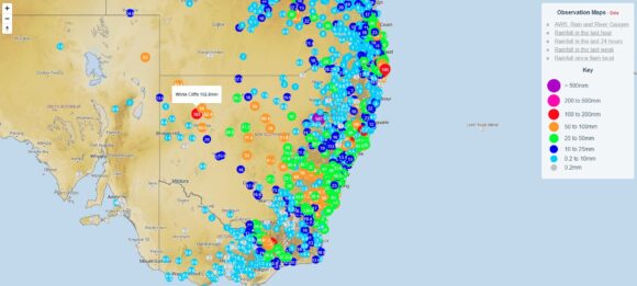
While models suggested at least 25 to 50 mm of rain would fall within a narrow path of New South Wale aligned in a north west to south east direction, there was heavier rainfall in areas where such falls would rarely occur. These included:
- Borrona Downs - 86 mm.
- White Cliffs - 86 mm. (White Cliffs for the week ending Saturday 10 February received 102.8 mm which is unusual given the climate of the region).
- Okeh - 84 mm.
- Killala - 77 mm.
- Condobolin - 68 mm.
- Nyngan - 66 mm.
- Orange - 64 mm.
- Forbes - 56 mm.
There were widespread 30 to 50 mm falls affecting regions the cloud passed over.


A separate event occurred over portions of North East Victoria during the same period dropping 106 mm at Falls Creek and 82 to 93 mm around Mt Buffalo. These were thunderstorms or heavy rain showers and were largely hit and miss events. Additionally, while 20 to 30 mm fell around Wangaratta, barely 7 mm fell around Albury showing how hit and miss the events were.
Attached are the rainfall figures for the week ending Saturday 10 February 2024 and the cloud satellite picture for New South Wales for Monday 5 February 2024 (NASA Zoom Earth) showing the cloud mass that contributed to the short lived event.
Note: The feature image attached is not from this event but one showing a clearing storm looking east. At daybreak, the early morning rain and thunder that passed over Sydney cleared rapidly out to sea.
