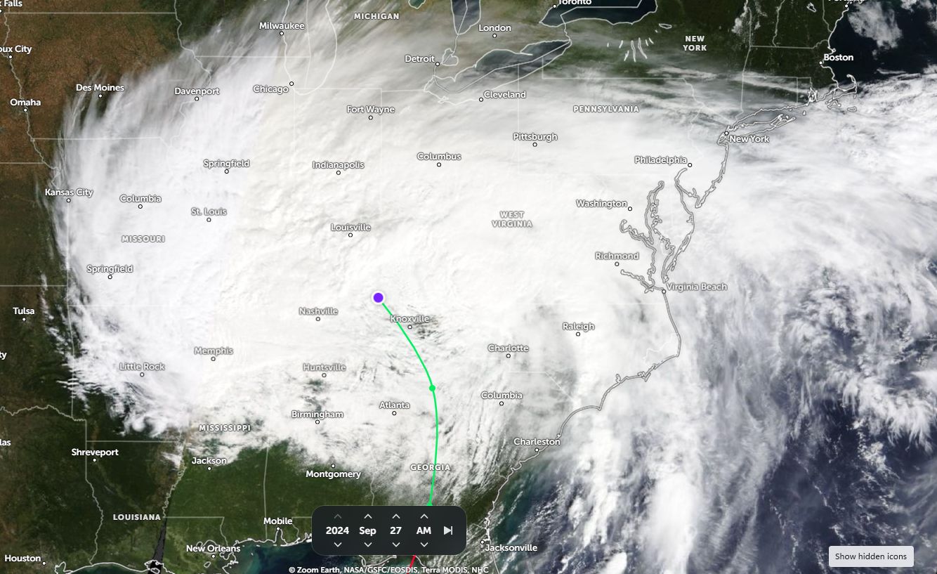
The aftermath of the landfall of the Category 4 Hurricane Helene on Thursday September 26 is expected to be felt for years to come as recovery efforts intensity. This single event is likely to the major weather event for 2024 in terms of its impact, its aftermath and final cost.
Some impacts of the storm event and media reports coming out of the affected areas is incredible and at the time of writing, the following is already identified:
- The storm is now the fourth deadliest hurricane event since 1950 to strike the United States and the deadliest since Hurricane Katrina impacted New Orleans in 2005. Already the death toll has soared above 220 (226) but still climbing as more areas are reached by rescue workers. The death toll will continue to rise in coming days and weeks.
- The earliest preliminary costs of damage is calculated at a minimum $30.5 billion and upwards of $45.5 billion. It is identified that insured loses range from $10.5 billion to $17.5 billion but a vast majority of residents do not have insurance and thus the figures being quoted by news reports are estimates that will change (Most likely will rise significantly). It is unclear what will happen to those who do not have insurance. Certainly, this is a critical issue in this part of the United States that will need to be addressed.
- A weather station called Busick RAWS in Yancey County (North Carolina) recorded 31.33 inches of rain during this event (Calculated at 795.7 mm of rain between September 25 and 27 being the highest official rain total).
- Another weather station being Mt Mitchell ECONet also in Yancey County recorded 24.41 inches (Calculated at 620 mm of rain during the same period) being the second highest total.
Given the mountainous terrain, such rainfall figures resulted in riverine flooding, flash flooding and mudslides that contributed to the catastrophe.
- Ashville is a significant population centre (Home to approximately 95,100 residents but part of a much larger urban region of 513,720 residents - 2023) that was heavily impacted by flooding and flash flooding. The city Airport weather station recorded 13.98 inches (Calculated to 355.1 mm) for the 2 day period. There is considerable damage across the city and a high loss of life. Additionally, the city was left isolated due to major roads such as I 40 and I26 being cut.
- The storm also produced at least 6 confirmed tornadoes with one reaching a strength of EF3 in Rocky Mount.
I have looked at this event on “Georgia Power”, a major electricity provider for the state of Georgia and some of the electricity infrastructure impact repair works undertaken or required is staggering including:
- Having restored power to approximately 1.14 million customers.
- The need to replace 8,000 plus downed power poles.
- Repair and replace 21,000 spans of power lines between poles which is the equivalent of 1,609 km of wiring.
- The need to replace at least 1,500 electricity transformers.
- The need to remove up to 3,200 trees which have fallen across power lines.
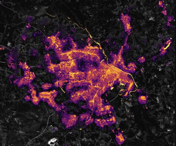
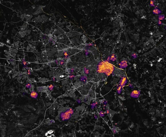
A large region of the United States southeast was without power and still is following the hurricane. To highlight some dramatic impacts under the “Black Marble Project” and using the VIIRS on the Suomi satellite, the city of Augusta is shown before and after the storm. Following the storm, other than the central business district of the city, the city suburban areas is mostly darkened.
A similar result has occurred at Valdosta (Lowndes County) Georgia.
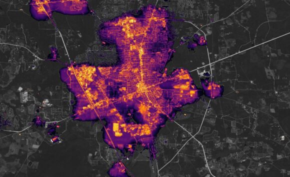
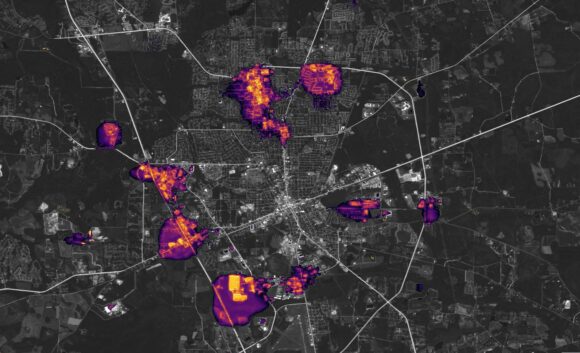
On a much larger scale, similar style blackouts have occurred elsewhere in other affected states which explains why millions of residents were left without power for days.
What is certain is that it will take years for the recovery efforts to be completed and given what the storm has done, the National Weather Service will retire the name Helene from its future named hurricane lists. In other words, there will never again be a Hurricane Helene similar to what was done for Camille (1969) and Katrina (2005).
I have attached to this:
- A post satellite image of the hurricane (Post landfall) – NASA Zoom Earth taken Friday 27 September 2024.
- NASA Images of Augusta City and Valdosta before and after images (VIIRS) – Earth Discovery Saturday September 28 2024.
