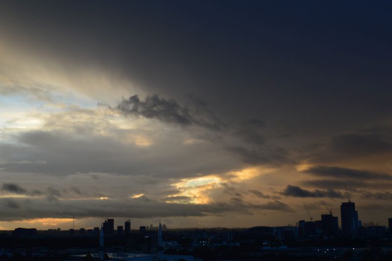
The photos attached were taken at sunrise Friday morning 7 June 2024 at Auburn looking east and south. When matched against the radar image of Sydney, it is shown that the primary rain band affecting Sydney earlier had shifted just to the south of the city and training over the same area for hours resulting in 100 mm plus rainfall totals.


This was the time that overnight rain over Sydney was breaking into showers and commencing a clearing trend with the rain starting to shift southwards.
While nimbostratus cloud featured, embedded cumulonimbus clouds were also visible along the coastal areas marking areas where heavy coastal rainfall was occurring.
The same system impacting the coastal area between Sydney to the north and Batemans Bay to the south has been delivering high rainfall totals for 3 days with rain training over the same areas for hours.


During Thursday, it was the Nowra region of the New South Wales South Coast that experienced the highest rainfall totals. During Thursday, the rain gradually crept northwards reaching Sydney mid to late afternoon. The system delivered some moderate to high rainfall totals across the city with the heavier falls occurring closer to the coast and the south western suburbs.
Overnight Thursday / Friday morning, the rain then contracted southwards delivering the heaviest falls around the Illawarra region where 100 mm totals were common.
Throughout Friday, the system contracted further southwards delivering moderate rainfalls around Ulladulla to just north of Batemans Bay.
This is the second major rain event for coastal New South Wales including Sydney within the space of one week. As a result:
- Rainfall totals along parts of coastal Sydney has topped 248 mm being Rose Bay followed by 237 mm at Little Bay for the week ending Saturday 8 June 2024.
- Currarong has had over 309 mm for the week ending Saturday 8 June 2024.
- Cumulative rainfall totals of 200 mm or more over the past 7 days have been common within coastal areas between Wollongong to the north and Nowra to the south. This has resulted in localized flooding of low lying areas seen on news bulletins.
- It appears that rainfall at Sydney Observatory Hill has now exceeded 1,000 mm so far for 2024. While 895.2 mm is official to 9 am 8 June 2024, the rain gauge was not working on February 20 and April 6 being two days when rainfall occurred at this location. The estimate is much higher than that stated. This has occurred less than 2 years after Sydney Observatory Hill recorded its all time high rainfall tally for any given year.
The highest rainfall figures from the most recent event are:
To 9 am Thursday morning 6 June 2024 (Focusing on the Nowra region)
- Currawong - 188 mm.
- Vincential - 177 mm.
- Tomerang - Creek 152 mm.
- Beaumont - 140 mm.
- Tomerong - 135 mm.
- Nowra (Shoalhaven) - 123 mm.
To 9 am Friday morning 7 June 2024 (Mainly the Illawarra region)
- Port Kemba - 204 mm.
- Warilla - 184 mm.
- Mt Pleasant - 174 mm.
- East Kangaloon and Foxground - 161 mm.
- Kiama - 152 mm.
- Macquarie Pass - 140 mm.
- Mittagong - 132 mm.
Coastal Sydney received 32 mm to 74 mm with the highest fall of 74 mm at Bondi.
South West Sydney received 50 mm to 79 mm.
Western Sydney received 24 mm to 40 mm.
To 9 am Saturday morning 8 June 2024 (Mainly South Coast near Ulladulla)
- Ulladulla - 90 mm.
- Jerrawangala - 75 mm.
- Tomerong - 61 mm.
Attached is the final cumulative weekly totals to 9 am Saturday morning showing the areas most affected by the two recent events.
