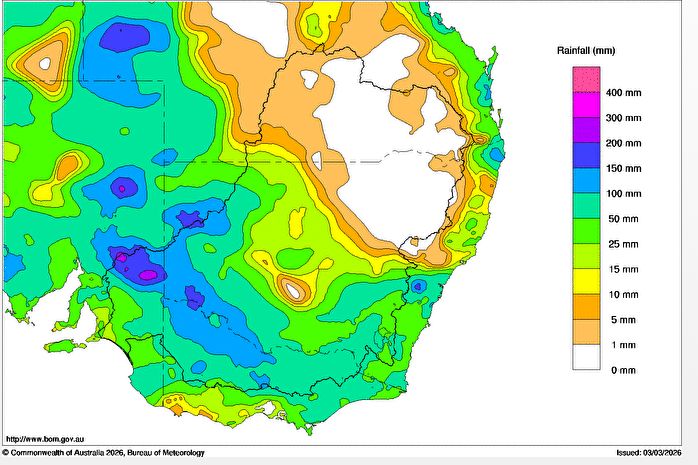
The same weather system impacting four states across the previous week had its final conclusion during the first 4 days of March 2026. The event that brought widespread rain across outback regions of the Australian continent brought significant rainfall to northwest Victoria and far southwest New South Wales during Sunday and into Monday.
The regional city of Mildura received 83 mm of rain to 9am Monday which concluded the event. Coupled with 65.8 mm the previous day, the two day total for Mildura reached 148.8 mm resulting in some flooding of low lying areas.
Solid falls also fell at:
- Tutye (Bunurouk) Comparison – 91.4 mm.
- Walpeup Station – 76.6 mm.
- Swan Hill – 65.8 mm
- Kyabram – 64.2 mm.
- Wombera Station (Northeast of Mildura) – 57 mm.
In New South Wales, the township of Hay (Western Riverina) received 55.6 mm and a remote location north of Broken Hill received 103 mm being Mt Woowoolarah.
This was the area hardest hit by the extended dry and such falls have been welcome.
Across northern and Central Victoria, falls of 40 to 60 mm were commonplace with isolated higher totals of 70 mm occurring.
Monday afternoon, the system crossed southern New South Wales and into northeast Victoria producing falls of between 30 mm and 50 mm at most weather stations. This included:
- Hunters Hill – 55.2 mm.
- Wagga Wagga – 45.6 mm.
- Wangaratta – 39.8 mm.
- Albury Airport – 33.8 mm.
As the system progressed into the Central Tablelands a few locations near Bathurst and Orange received falls of 50 to 90 mm including:
- Mandurama Post Office – 90 mm.
- Cowra Airport – 80.6 mm.
- Walli – 61 mm.
The same system crossed Sydney Monday afternoon providing much cloud and light rainfall totals.
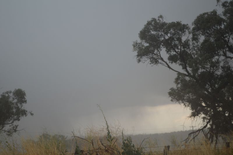
However, Wednesday afternoon March 4, a very slow moving thunderstorm brought intense rainfall across much of Western Sydney.
I finished work late and unable to get any photos of this. On the way home, I was observing a solid cloud base to the west but as I neared Doonside the structure fell apart. As the storm passed over, strong rainfall occurred and rainfall totals reached 20 mm over a short period of time including 20.3 mm in my personal rain gauge. The storm eventually crossed much of Sydney but weakened further east before it crossed out to sea.
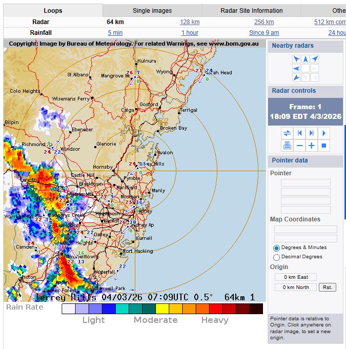
I attach the weekly rainfall plot to Tuesday that captures the extent of the rainfall across southern Australia and the radar image of the storm crossing Sydney Wednesday afternoon.