Tropical Cyclone Zelia developed during Wednesday morning and finally crossed the Pilbara coast of Western Australia Friday afternoon over a locality called De Grey. The exact area of landfall was the De Grey River mouth.
Perhaps the closest settlement to the eye and where landfall occurred was Marta Marta.
The area of landfall is mostly uninhabited. The nearest town of any size to landfall was Port Headland which lies approximately 60 km to the west.
This is perhaps fortunate as Zelia was perhaps the strongest tropical cyclone to strike the Pilbara region since Tropical Cyclone Dean back in 1980. Zelia defied all the odds and forecasts for a number of reasons:
- At one stage during Monday and Tuesday, there were doubts that the storm would even develop into anything significant given the amount of shear that was occurring.
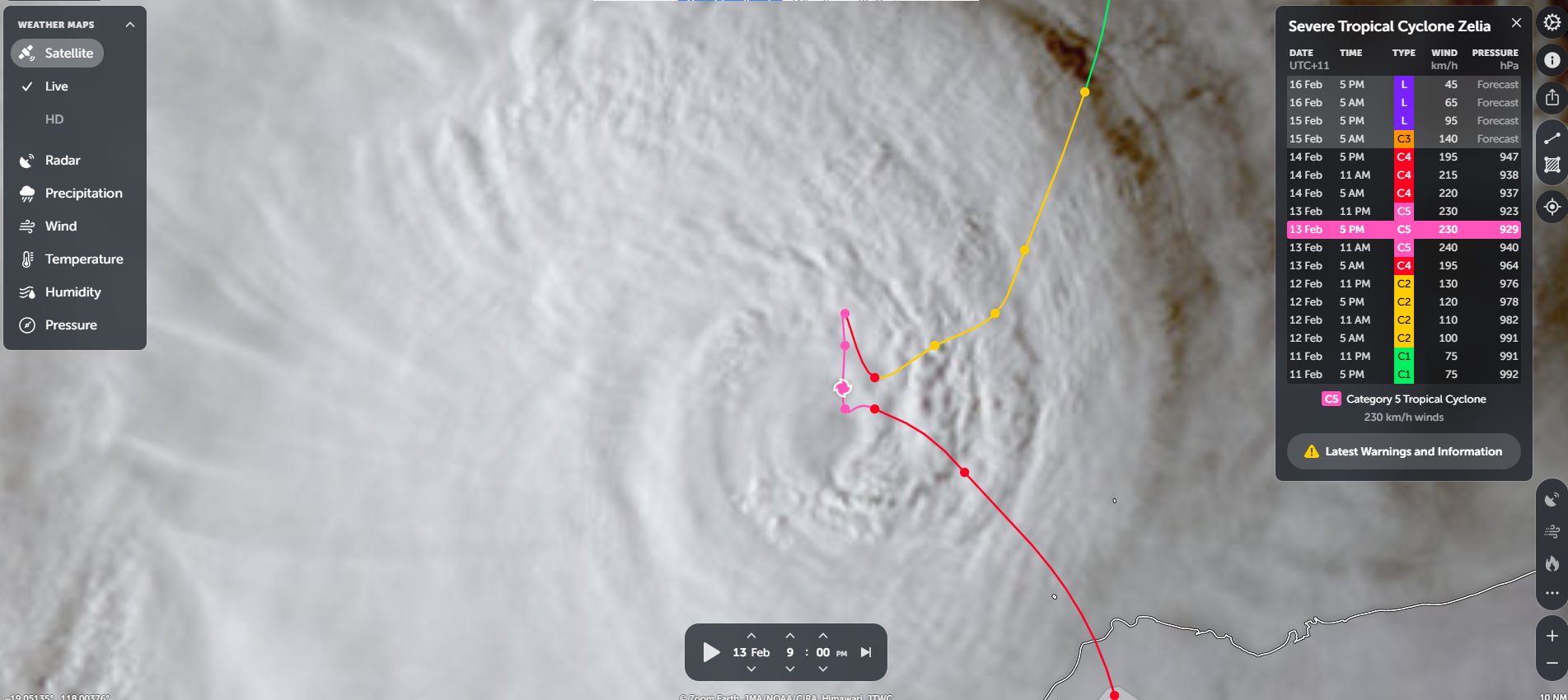
- The storm was only forecast to reach Category 2 on the Saffir Simpson Scale based on early models being presented. In this regard, this storm reached a Category 5 system defying all initial forecasts.
- The storm was very slow moving and even at times became almost stationary.
- The storm was barely traveling at 14 km/h during Thursday. This changed during Friday in which the storm picked up speed and traveled south to cross the coast (Speed at landfall increased to at least 19 km/h).
- The storm only traveled a short distance during its 3 day lifespan.
- The lifecycle of this storm is amazing as it reached Category 5 in less than 2 days after forming. It crossed the coast as a Category 4 system.
The storm formed over waters heated to 31C to 32C.
While weather models were eventually suggesting peak wind gusts of over 140 knots or 253 km/h at the core, the problem that exists is that the region where landfall occurred lacks good coverage in terms of reliable weather stations.

The best data available in terms of wind speeds are:
- Rowley Shoals where a single peak wind gust of 119 km/h occurred at 1.30 am Wednesday morning. The core of the storm at this time was to the south of the island group.
- Port Headland in which a single peak wind gust of 120 km/h occurred Friday afternoon as landfall was occurring.
The true strength of the winds at the core can only be estimated due to lack of coverage across the De Grey region.
This is made worse because a weather station on Bedout Island failed at a critical time when the eye was close to the island.

The storm produced heavy flooding rains including:
Port Headland
- 75 mm to 9 am Wednesday morning.
- 93 mm to 9 am Thursday morning.
- 6 mm to 9 am Friday morning.
- 35 mm to 9 am Saturday morning.
Total = 253.6 mm across the 4 day period.
Heavier totals occurred elsewhere including:
- De Grey (Rain gauge only) – 261 mm to 9 am Friday morning.
- Pardoo Station (Rain gauge only) – 208 mm to 9 am Friday morning.
- Yarrie – 166 mm to 9 am Saturday Morning.
- Marble Bar – 203 mm to 9 am Saturday morning.
- Upper North Pole – 278 mm to 9 am Saturday.
Such high rainfall totals lessened in areas further south.
Evacuation and road closures did occur but given that landfall occurred over a remote location, the impact of the storm is not expected to be significant.
Attached to this are the images from NASA Zoom Earth 2025 showing the storm at different stages of development. This was a small but powerful storm.