As anticipated, a storm chase was undertaken from Batemans Bay to Sydney during the 8 hour period from 12 noon to 8 pm Saturday afternoon and early evening.
Note: I had to go down to Batemans Bay in relation to a separate matter which was not related to any storm chase. The chase was undertaken for the return drive. While 700 km was driven for the day, the main chase only covered approximately 370 km.
I left Batemans Bay and my parents at 12 noon once I was satisfied that convection had commenced to the west near Braidwood. Upon leaving Clyde Mountain and heading towards Braidwood, I could see some strong updraft towers to the west.

I arrived at Braidwood close to 1 pm then proceeded further west where I spent some time watching cloud development.
Thunderstorms were developing across the ranges to the south west around Cooma and within areas where road networks were poor. I then went north only because I was noting better weather conditions and stronger heating which later proved to be a very good move.
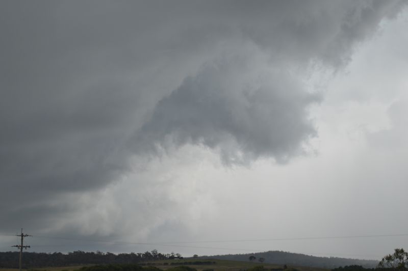
I made short stops at Warri then a rural area approximately 6 to 8 km from the Braidwood Road (The road that connects Braidwood with Goulburn and Tarago).


Here I watched an interesting thunderstorm that lasted up to 1.5 hours. The storm propagated to the east then kept back building northwards. Strong updraft towers featured across its northern areas while the rainfall fell across its southern side. The storm seemed to have some organization for a while.


The storm only died because a cluster of thunderstorms developing to the west had encroached into the Braidwood and Bungendore region. This system was taking the energy of the day with it. I drove further west towards Bungendore to encounter a small storm cell that passed overhead ahead of the much stronger line that was further west.
The main system further west became linear. I parked off the Kings Highway and let it pass over me. This gave me the chance to take photos of the conditions. I encountered heavy to very heavy rain and even small sporadic hail and strong winds.
Following this, I turned around and caught up with the storm. I kept going, turned north along Braidwood Road driving through intense rain at times. I was on the lookout for hail fall but found nothing. South of Tarago, I drove out of the north west side of the storm and the system slipped away to the south east. I had to let the storm go as no roads existed that went southeast.


After checking the radar, I worked out that the main storm system was encroaching onto Marulan and if I could make up the 64 km, then I had a chance of catching up with the main squall line.
I drove north to Goulburn, entered the M31 and made my way towards Marulan. Northeast of Marulan, I was able to catch the main squall line and drove into it. There were indeed some powerful cloud to ground lightning strikes and very intense rainfall and even flash flooding. Rain driven wind was also a feature.
I noted most drivers pulling over due to very poor visibility and poor road conditions. I moved into the right hand lane and pressed while passing countless drivers driving slow or pulling over. This storm was severe warned for intense rain and given what I encountered, the warning issued held true.

I was able to pass through this to the northern side where I cleared the storm and made my way back to Sydney in light rain which became later patchy light showers.
At night around 9 pm, the same system passed over Western Sydney producing some significant and heavy rainfall around parts of Western Sydney.
My rain gauge showed 32.6 mm. There are other isolated high totals across Sydney including:
- Cronulla South Bowling Club – 59 mm.
- North Richmond – 46 mm.
- Kurrajong Heights – 35 mm.
An isolated total of 96 mm fell at High Range on the Southern Tablelands.
Such high totals are isolated but intense rainfall fell where a storm core passed over. This is similar to what I encountered north of Marulan and the rural area east of Bungendore.
Some features of the storm event include.
- Storm tops went up high.
- Intense rainfall fell.
- Hail while it certainly occurred does not appear to have been the primary issue (Certainly within the areas that I was in).
- Strong cloud to ground lightning strikes featured.
It should be known there appears to have been a single fatality south west of Sydney from a storm with a lightning strike likely to be the cause.
I have attached photos from the days chase and a map showing where the storms of the day were encountered.