http://www.extremestorms.com.au/a-two-day-heat-outbreak-across-southern-england-18-and-19-july-2022/
For the first time ever, maximum daytime temperatures in England appear to have topped 40C (104F). At the time of writing, the highest recordings are only “provisional” and are being scrutinized for accuracy and to ensure the recordings are made in the correct manner.
The “Met Office” which is England’s equivalent of the Australian Bureau of Meteorology does scrutinize such readings carefully to ensure that there are no outside factors impacting the weather stations as such cases can and have been known to occur. Provisionally, the following is known:
- At least 34 weather stations across the country recorded a new maximum daytime temperature record.
- A provisional maximum temperature of 40.3C was recorded at Coningsby Air Force Base in Lincolnshire.
- A provisional maximum temperature of 40.2C was recorded at Heathrow Airport. These two are the highest recordings for the day being Tuesday 19 July 2022.
- A minimum overnight temperature of 25.8C was recorded at Kenley in Surrey located on London’s southern outskirts.
- A temperature of 38.1C was recorded on the Monday 18 July at Santon Downham in Suffolk.
Note. If the 38C recorded on the Monday is confirmed, then it can be said that temperatures reached 38C on 2 days in a row somewhere in England which again would be unprecedented.
It must be emphasized that the two locations that recorded 40.2C and 40.3C are in fact airports where asphalt and concrete surfaces pre - dominate. It is possible that an urban heat island effect played a role given that building materials absorb heat more efficiently than a vegetated ground surface although the impact and the role this may have played is still under investigation.
The 40.3C measured at Coningsby in Lincolnshire appears to have been measured accurately in a weather station in the shade and 1.5 metres above the ground surface.
At present, there are also other maximum daytime highs being investigated for accuracy including:
- Gringley on Hill, Kew Gardens and St James Park 40.1C.
- Northolt 40C.
- Hull 39C.
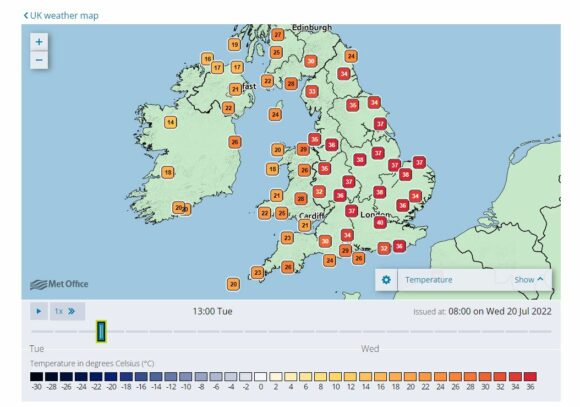
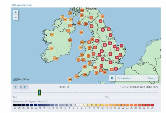
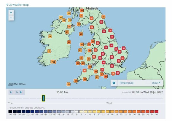
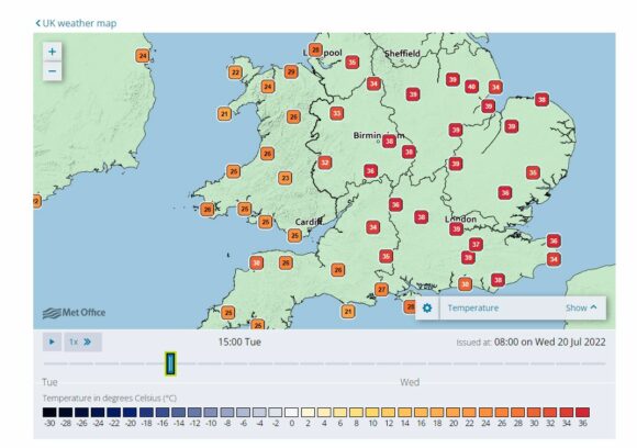
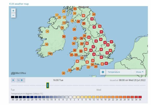
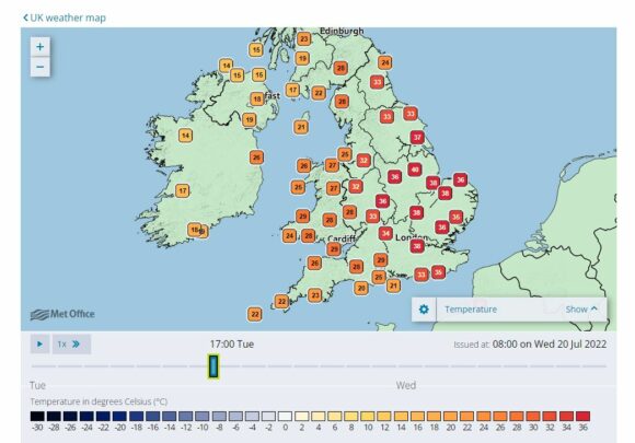
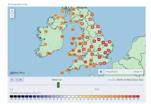
As shown in the hour by hour temperature recordings taken from ‘The Met Office” for England, high temperatures of 38C or above were sustained for a period of at least 5 to 6 hours during Tuesday.
- The 1 pm temperature reading shows a high of 40C at London (Actually taken at Heathrow Airport) and with four other centres recording 38C.
- The 2 pm temperature plots show 39C at the same location but with 2 other centres recording 39C and 5 other centres recording 38C.
- The 2 pm temperature plots show 39C at the same location and 7 other centres recording 38C and 39C respectively.
- The 3 pm temperature plots show 38C and 39C at 10 locations across a wide area of Eastern and Central England.
- The 4 pm temperature plots show 38C and 39C being recorded at 5 locations.
- The 5 pm temperature plots show 38C and 39C at 4 locations and a 40C being recorded at a location (Actually near Waddington).
- The 6 pm temperature plots show 1 location recording 39C.
The above and attached plots clearly shows that a large portion of England (At least the east and south east) did experience an unusual burst of heat.
The plots also show that the western part of England did not experience this heat during Tuesday and the approach of a cold front / cooler change would have had an impact.
The evidence of 40C being topped is credible given how widespread this was.
This heat led to outbreaks of fires and significant disruptions to a society that is unused to such high temperatures.
England sits 50 to 55 degrees north of the Equator and if the country was situated in the southern hemisphere at the same latitude, it would sit approximately 800 km south of Tasmania. It makes the Tuesday heat even more remarkable.
The level of heat had its greatest impact across Spain, Portugal, France where maximum temperatures have reached well into the 40S resulting in major outbreaks of bushfires and loss of property. There is also a drought in the affected areas which has contributed to the crises impacting the region.
I have managed to locate some recent temperature records for England in the Met records which can be used to measure the most recent burst of heat. The previous English maximum temperature records are:
- 36.6C at Worcester on the 2 August 1990 (Worcestershire).
- 36.7C on the 9 August 1911 at Raunds (Northhamptonshire).
- 37.1C on the 3 August 1990 at Cheltenham (Gloucestershire).
- 38.5C on the 10 August 2003 at Faversham (Kent).
- 38.7C on the 25 July 2019 at Cambridge (Cambridgeshire).
Further research suggests that the summer of 1976 was also quite significant for England however the maximum daytime temperature that can be identified is a peak of 35.9C recorded at Cheltenham on the 3 July 1976. It is also understood that during 1976, there was a period of drought for much of England.
The attached temperature plots are taken from “The Met Office” temperature recording for England between 12 noon and 6 pm Tuesday afternoon.
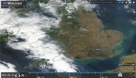
A detailed satellite photo of most of England is attached with place names included. The image is showing completely clear skies over much of southern and Eastern England and a cold front entering the west of the country. The heat occurred ahead of that cold front and cloud mass. It is also noted that much of south east England has dried out considerably when compared to the west coast. The level of heat was dragged north by a strong high pressure cell ahead of a cold front / cooler change which incidentally crossed the remainder of the country during Wednesday.
