
During the last 10 days of June and the first 9 days of July 2016, winter has taken hold across south east Australia. A succession of cold fronts has brought gales, rain, and snow to low levels across Tasmania, Victoria and New South Wales.
Now another system is bearing down across the south east for Sunday to Tuesday that is expected to bring low level snowfall possibly as low as 500 metres in elevation by Tuesday to the the higher elevations of Victoria. Forecasts of snow as low as 700 metres are being made for certain areas of New South Wales such as the higher areas of the South West Slopes and Central Tablelands during Tuesday.
Over the past few weeks, the ski resorts of South East Australia have enjoyed significant snow falls with snow depths now varying from 50 to 80 cm with Mt Buller having a maximum depth of 80 cm where snow making is occurring.
There have also been snow across the Central Tablelands and light falls into the Northern Tablelands to places such as Guyra.
During the period June 24 to June 27, a more significant cold outbreak occurred across the inland of the south east with maximum temperatures struggling to reach 10C across many centres such as:-
1 - Albury 26/6/16 - A minimum temperature of minus 1.3C and a maximum temperature of 7.5C.
2 - Bathurst 27/6/16 - A maximum temperature of 6.2C.
3 - Cooma - There were 3 days of in a row where the maximum daytime temperature failed to reach 9C.
4 - Oberon (24 to 29 June) The maximum temperature failed to reach 7C on 5 consecutive days with the coldest being 1.9C on June 25.
5 - Orange 25/6/16 - The maximum daytime temperature reached 3.1C.
Even in Western Sydney, there have been bursts of cold such as what occurred on June 27 where maximum temperatures struggled to reach 12C or 13C.
In Sydney (Observatory Hill) the maximum temperature reached just 11.7C on the 27/6/16. Such low maximum daily temperatures for Sydney City are rare.
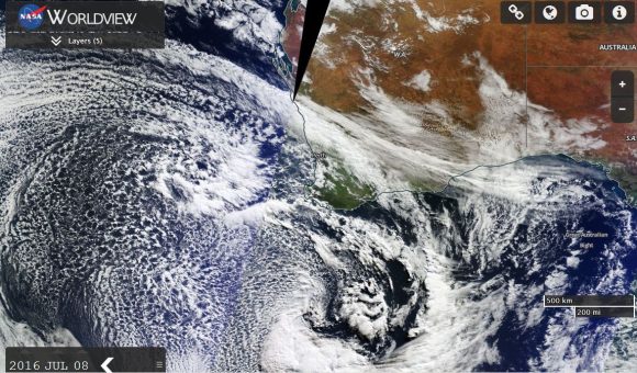
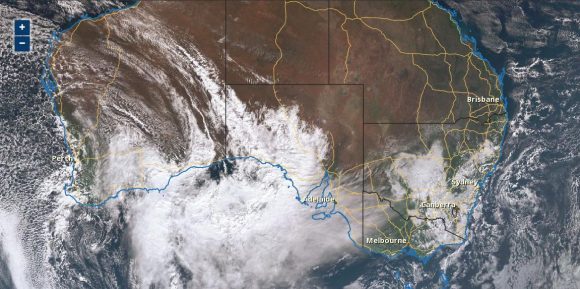
As shown in the attached satellite photo of Southern Australia 9 July 2016, the next winter cold front will be significant as it crosses the southern part of the continent. It is projected to produce gales, cold weather thunderstorms, local hail and low level snowfall to a large region of the south during the early part of the new week.
Coastal New South Wales will be spared the worst of this system.
Certainly in Victoria, warnings are already issued for damaging winds of up to 90 km/h across elevated parts of the state (NE Victoria) as well as low level snow falls once the system passes through.
The attached satellite images show the cloud mass ahead and with the next winter front as it passes across the south that will produce a cold outbreak in coming days.
Credits
1 - Bureau of Meteorology - Weather data and temperatures and satellite image of cloud mass.
2 - NASA (Worldview) - Image showing the winter cold front approaching Western Australia on 8 July 2016.

The attached satellite photo of Southern Australia is now showing a remarkable cold front and associated low pressure system passing through southern Australia. This is the system that will provide a true winter outbreak over coming days that will produce snow to low levels for New South Wales, Victoria and Tasmania.
The cloud ahead of it contains a rain band but falls are not expected to be significant. The main cold air mass is currently passing through the Great Australian Bight and it is that cold air that will provide a true winter outbreak during Monday and Tuesday.
Cold air will surge through southern Australia especially Tuesday. Following in its wake, a new high pressure system will build but night time temperatures will plunge and morning fogs and frost will feature across many inland areas during the mornings. Following the passage of this system, there will be some cold nights by weeks end.
During Tuesday and Wednesday 12 and 13 July 2016, a vigorous and intense cold front surged through southern Australia producing gales, low level snowfall to as low as 300 metres across Victoria and some very cold temperatures.
While the front was short lived, it left its impact across South East Australia.
Unfortunately gales resulted in a tree being brought down on the M1 Motorway and a resultant fatality.
The satellite photo of the Snowy Mountains from NASA Worldview attached is showing extensive snow cover across the region and snow extending towards the Cooma region following the passage of the front. Extensive snow fell across all New South Wales ski resorts. Some notable cold maximum temperatures for the day included:-
Bathurst – Minimum 2.2C and a maximum 6.5C.
Cooma – Maximum 6.5C.
Oberon – Minimum minus 8.5C and a maximum of 2.8C. Thursday – Minimum 1C and a maximum of 6C.
Orange – Minimum 0C and a maximum of 4.5C. Thursday – Minimum minus 0.4C and a maximum of 4.9C.
Wagga Wagga – Miniumum of 3.4C and a maximum of 8.9C.
Maximum temperatures across Sydney struggled to reach the range of 12C to 14C for the day despite the fact that it was sunny.
Conditions moderated relatively quickly during Thursday and Friday.