A combination of several factors including a very slow moving high pressure cell, a Tasman Sea low and a surge of cold air from the south has resulted in some significant cold, showery and windy weather across south east Australia for the past 5 days.
The weather event has led to a significant cold outbreak that would be expected during May to July. The cold outbreak is now spanning 5 days and hence its longevity is noteworthy. Interestingly, the night time minimums while slightly below average is not a significant issue. It is the maximum daytime temperatures being recorded that have been noteworthy and numerous centres across south east Australia have been experiencing maximum temperatures that are well below the long term average.
Some noteworthy facts of this cold spell include:-
1 - Sydney City Observatory Hill recording maximum temperatures of less than 17C on the 23, 24 and 25 September being 16.2C, 16.3C and 16.2C. This is significant because the average maximum September temperature is 20C for the month.
2 - Maximum daytime temperatures have been falling to as low as 13C to 14C such as at Nowra (24/9/15). The average daytime maximum temperature for September for Nowra is 21.1C.
3 - Rainfall was initially confined to the coastal fringe but during Thursday and Friday, rainfall spread more inland from the coast as winds turned more south east. There have been some reasonable rainfall totals such as 51 mm to 61 mm at Port Macquarie (Reading to 5 am 26/9/15). There has been other reasonable rainfall events such as 58 mm at Gosford (Reading to 9 am 25/9/15).
3 - There have been some significant wind gusts recorded along the coastal fringe including a gust of 96 km/h at Green Cape and Nobbys Head on the 23/9/15. There was a peak wind gust of 102 km/h recorded at Wattamolla AWS and a peak wind gust of 94 km/h at Montague Island Lighthouse on the 24/9/15. On the 25/9/15, a wind gust of 91 km/h was recorded at Wattamolla AWS at 3.01 am.
The weather event is producing some interesting weather spanning 5 days of wind, cold and rain and is an effective return to winter like conditions. Conditions are now expected to improve slowly. A sample of what has been occurring is provided below.
MAXIMUM DAYTIME TEMPERATURES (22 to 25 September being a sample)
Newcastle - (Average September max is 20.3C) 22/9 - (19.3C), 23/9 - (14.4C), 24/9 - (16.6C), 25/9 - (17C).
Nowra - (Average September max is 21.1C) 22/9 - (17C), 23/9 - (16C), 24/9 - (13.4C), 25/9 - (16C).
Penrith - (Average September max is 21.7C) 22/9 - (21.7C), 23/9 - (18.4C), 24/9 - (17.5C), 25/9 - (17C).
Prospect - (Average September max is 21.4C) 22/9 - (20C), 23/9 - (16.9C), 24/9 - (16.3C), 25/9 - (15.9C).
Sydney - (Average September max is 20C) 22/9 - (19.5C), 23/9 - (16.2C), 24/9 - (16.3C), 25/9 - (16.2C).
Wollongong - (Average September max is 20.2C) 22/9 - (16C), 23/9 - (14.9C), 24/9 - (14.4C), 25/9 - (16C).
Ulladulla - (Average September max is 19.2C) 22/9 - (16C), 23/9 - (14.1C), 24/9 - (13.9C), 25/9 - (15C).
RAINFALL
Rainfall only became significant during Thursday with the heaviest falls being to 9 am 25/9/15
Sydney Metropolitan area
38 mm at Frenches Forest, 37 mm at Randwick and 36 mm at Mona Vale Golf Club. Rainfall dropped sharply further west. The heavier falls were concentrated across NE Sydney and eastern Sydney.
Other rainfall (To 9 am 25/9/15)
Gosford 58 mm, Wyoming 56 mm, Kincumber 51 mm and Lisarow 48 mm.
Falls such as this were very sporadic in nature.
Rainfall to 5 am (26/9/15)
Port Macquarie 51 to 61 mm, Forster 60 mm and Laurieton 53 mm. The falls are sporadic in nature.
Coffs Harbour 31 to 36 mm.
Sydney (Bondi 14 mm).
WIND
As previously mentioned, the highest wind gust recorded is 102 km/h at Wattamolla on the 24/9/15. There are strong wind gusts of 70 to 80 km/h being recorded along the coast but this is limited to the exposed coastal areas or at weather stations on offshore islands such as the station on Montague Island off Narooma.
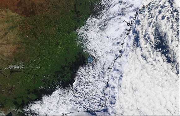
Satellite photo 25/9/15
The attached satellite photo from MODIS is showing the typical cloud formations along the coast from this event. Coastal showers have been a feature of the event and such formations of low level cloud has been persistent. None of the shower activity is penetrating inland.
CREDITS
1 - NASA (MODIS) image acquired 25/9/15.
2 - Bureau of Meteorology for rainfall and temperature data for the 22 to 26 September.
3 - Australia Weather news and data 23/9, 24/9 and 25/9 (Wind data observations).

