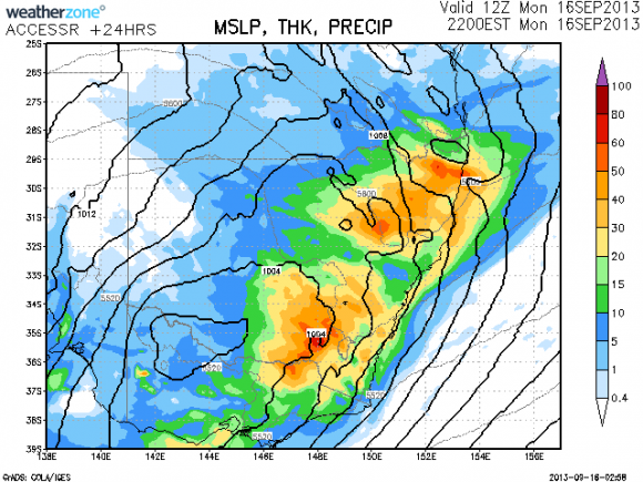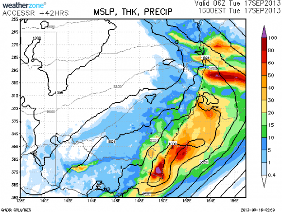
 It seems likely that storms and rain will occur over the southern inland of NSW today and then the coastal fringe by tomorrow morning with falls nearing or exceeding 100mm on the far south coast according to the latest models. Generally, most falls will be less than 50mm but for some regions, this will end a long period of dry of about 6 months with little or no rain and temper the hot start to prong.
Given the cold air aloft and surface, there should be storms (storms are occurring already and rapidly moving east across NSW)

The rain event has unleashed some impresive rainfall totals in addition to some unusual rainfall variations across short distances and across small regions.
Illawarra NSW:
I have reviewed the rainfall totals for the 24 hours to 9 am 17/9/2013 from the BOM Water and the Land website for the Illawarra and have discovered incredible variations. For example, in the coastal suburbs of Wollongong, rainfall varies from 40 to 60 mm which includes 52 mm at Port Kembla and 46 mm near Shellharbour. Yet if one travelled to the foot of the escarpment or onto the escarpment, rainfall totals soar from 100 mm to 180 mm. Figtree received 132 mm, Mt Pleasant 149 mm, Darkes Forest 125 mm and 174 mm at Brogers Creek. This is representative of the escarpment area and suggests topography and orographic influences have played a big role.
At nearby Robertson, a fall of 220 mm occurred but the highest fall was 256 mm at nearby Clover Hill. If one was travelling along the Illawarra Hwy during this event, a driver would have encountered very heavy rain on the escarpment within a small area. Either side of the escaprment, rainfall totals range from 40 to 60 mm. Moss Vale further west had 40 mm, Fitzroy Falls 59 mm and just 18 mm at Goulburn.
South Coast of NSW:
A similar but slightly less dramatic rain event has occurred within a small area centred around Moruya. A small pocket around Moruya received 100 mm to 205 mm including 205 mm at Moruya (Plumwood). The town of Moruya experienced 170 mm (The Lagoon weather station) and nearby Araleun had 143 mm. Falls were less either side such as 70 mm around Batemans Bay and 46 mm around Ulludulla further north.
Interestingly, falls were lighter further west around Cooma with 10 to 20 mm common.
Sydney NSW:
The Water and the Land BOM website for rainfall totals have been reviewed for Sydney for the 24 hours to 9 am for 17/9/2013.
Some quite dramatic totals are evident across Sydney and across small locations.
Quite interestingly rainfall of 11 to 14 mm occurred around Blacktown, Castle Hill, Prospect, St Marys and near Parramatta. This region appears to have missed out on the heavier falls further east and further west.
South Creek on Elizabeth Drive had just 7.5 mm.
Coastal Sydney enjoyed falls of 31 mm to 88 mm including 88 mm near Waverly, 86 mm near Miranda and 73 mm around Bondi.
Falls taper sharply west of a line from Hornsby to Parramatta south towards Bankstown.
However totals increase to 20 mm plus around Richmond south to Campbelltown the closer one is to the Blue Mountains.
Here at Blacktown where I reside, rainfall was light throughout the event and nothing significant occurred.
Inland NSW:
Excluding far west NSW and north west NSW which missed much of the rain, this event has delivered some healthy rainfalls across the wheat / sheep belt of the state and extending into Victoria.
Some thunderstorm activity was evident in some areas which boosted totals considerably. Many areas have had a dry period or even a dry winter leading up to this event.
Dubbo had 69 mm and Mudgee had 61 mm. Most towns and localities across the Central West picked up 34 mm to 70 mm.
Across the south west slopes and plains of NSW, falls of 23 mm to 54 mm are evident including 54 mm at West Wyalong, 49 mm at Carabost, 38 mm at Batlow and 37 mm at Albury Airport.
Similar totals occurred across the north west slopes of the state.
Canberra:
Unusually heavy rains have soaked the nations capital with 41 to 76 mm falling. Tuggeranong had the heaviest falls tapering towards the north west of the city.
It is understood further falls have occurred around Canberra after 9 am although they were lighter in extent.
North coast:
Unusual variations occurred with very light falls around the Bellinger Valley but some heavy falls around the Richmond Tweed area including 54 mm at Tweed Heads.
Areas around Mildura and Broken Hill missed out with just 1.2 mm falling.
Overall the eastern part of NSW including the cropping lands has received a critical rain event. There have been thunderstorms although I am not sure of any damage reports. I was aware of some warnings being issued for storms for hail and wind although I am unsure what has occurred.
Harley, that is a comprehensive coverage of the rainfall totals from this event! If you get a chànce, definitely post a rainfall map. Nevertheless it is welcome news for regions that have virtually missed rainfall for six months or more. At Scofields, we had a consistent 14.4mm that will help the otherwise dry paddocks.
As requested, I provide a rainfall plot from the “Water and the Land” for SE Australia including the Murray Darling Basin. It encompasses the past 7 days 12 to 18 September (Plot generated 18/9/13). It clearly shows that most rainfall has occurred across eastern NSW.
The heaviest falls by far have occurred within the SE part of eastern Australia with much lighter falls the further west. Essentially this was an event most welcome across the wheat / sheep belt of the country and the south east coast.