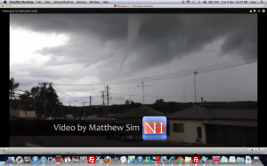
 Waterspouts were spotted off Newcastle and Central Coast this afternoon spawning a severe thunderstorm warning for winds. The main concerns were that strong winds associated with the waterspouts making landfall may cause localised damage as well as become life threatening in nature.
More waterspouts are possible this week as an onshore airstream persists with cold temperatures aloft.

Nice waterspout and associated video.
Actually, both videos shot from different perspectives show inflow bands. I wonder if this may have been a low topped supercell. We,ll have to check radar.
I haven't seen the radar images for this storm – but considering the weak shear in the lowest ~7 km, I suspect it was a non-supercell waterspout.
Michael Thomas fair enough. The storms were fibrous aloft too but that is definitely inflow on both videos.
Just had a look at the radar. Quite long lived for just a weak coastal shower/storm (lasted for more than an hour). Maybe there was something else going on – the structure does look reasonable too on that video. With the weak shear though, I wouldn't expect supercells. Maybe the storm tracked along a boundary of sorts. That may explain the storm's longevity and why it produced waterspouts.
I agree with what you say Michael Thomas – I always proclaim that use of the supercell term should be approached with caution. Mine was merely a loose ended comment based on some organisation and the fact that it may have been low topped. This was by no means a messy storm anyway.
Sweet video! I receieved an sms from my friend Dan that had a photo of a waterspout sent to him from a friend in Sawtell on the 7’th of April. I’ll see if he can get permission to post it up.