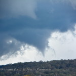
 Michael Bath has had positive confirmation that 4 tornadoes occurred in the region where he and Jason filmed a tornado last Saturday. Michael will post images and updates shortly.
Both the Bureau and a local in Guyra have confirmed other tornado tracks.
Jimmy

This is really interesting, I would love to see a map with the tornado paths overlaid. Will the BOM make a detailed analysis like this?
The Bureau does do surveys and writes reports but we may have to wait a little while for that to happen if it does. In the US, it is awesome – paths are done within a week or so.
The BoM have been up there but we may not get to see the results. I’ll have a map soon.
This is the doppler image at 4pm with two mesocyclones highlighted. The top one is where the photographed tornado was occurring. Southern meso is Wards Mistake (east of Guyra) where the southern storm touched down again after causing damage at Tenterden (WNW of Guyra).
Thanks for the information guys those Doppler images are really telling. I remember seeing similar returns from the Mt Stapleton radar for the storm near Marburg later that day, any signs of Tornado damage out there?
Also when events like this occur how come the BOM are so private with there findings like they are in the USA? Is it just that they don’t get funding to do in depth analysis?
I mean the BOM are *not like in the USA*
I haven’t seem much detail about that one Kane – missed a lot of media at the time. Yeah, the BoM person I sent my stuff to at NSW BoM didn’t even bother to say thanks after they asked for some pics. Thank goodness for great people like Harald Richter who share radar and analysis with us. The BoM may eventually put out a report.