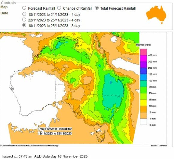
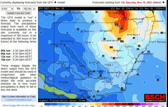
Weather models for the next 6 days across Eastern Australia are inconsistent but it is identified that a significant wet period is likely to unfold across the following areas or states:
- Eastern and inland Queensland.
- Australian Capital Territory.
- At least for 60% of New South Wales being the east and northern regions.
- Eastern half of Victoria east of a line stretching from Melbourne north to Echuca.
Any locality within these regions will receive at least a minimum of 5 to 10 mm of rainfall at some time during the next 6 days.
What makes this event significant is that it is occurring within an El Nino episode and indications are, some localities are likely to see significant events and rainfall totals occur.
Rain and even heavy falls plus thunderstorm outbreaks are likely to occur.


Updated models suggest cumulative totals could reach 100 and 150 mm at isolated locations including:
- Areas of the inland northern New South Wales and inland southern Queensland including towns and localities around Moree (New South Wales) and St George (Queensland).
- A small region north east of Dubbo (Possible up to 100 mm).
- An area around Lismore and north into south east Queensland.
There is a large swathe of New South Wales and Queensland where falls could reach 50 mm or more with that area stretching from Nowra in the south through to Sydney then north west all the way to near Cobar in Western New South Wales.
It is becoming clear that a significant event will occur and be concentrated across Eastern Australia with only the far west of New South Wales, Queensland and north west and west of Victoria missing out.
It also appears that rainfall will be concentrated:
- Much of Monday with a focus of heavy falls across the inland areas of Northern New South Wales Monday morning. This event at this stage should approach Sydney during the afternoon.
- Tuesday afternoon. It also appears that thunderstorm activity will become widespread across the inland south west part of New South Wales during Tuesday afternoon.
- Wednesday afternoon.
- Thursday and Friday afternoon across North East New South Wales and into Queensland.
It also appears that the official rainfall forecasts for Sydney across the next few days is currently underestimated being 0 to 36 mm (Cumulative totals) whereas models are clearly indicating falls greater than 25 mm with some suggesting 50 mm will be passed across most of the city.
For Canberra, cumulative totals of 7 to 36 mm are forecast which appears to be more accurate.
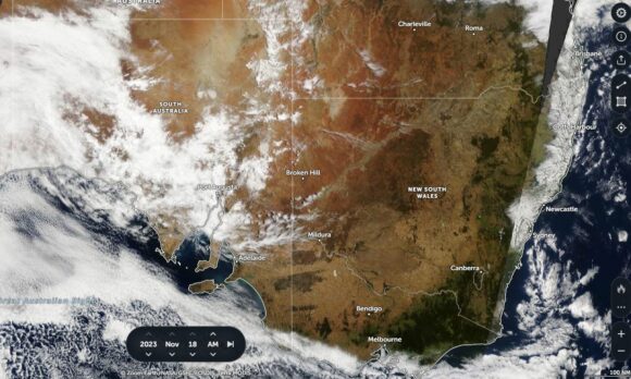
The satellite image taken from Zoom Earth NASA (Saturday afternoon) clearly shows the development of cloud over South Australia.


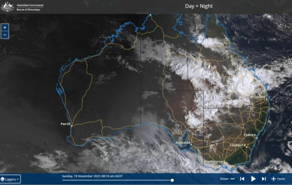
The Himwarri image of Sunday morning shows the cloud mass encroaching into Eastern South Australia, North West New South Wales and much of Queensland. It is this cloud and associated weather system that will encroach over eastern areas over the next few days and stall across the east delivering some interesting and varied weather.
Note: This system passed over the Alice Spring region during Saturday evening where 17.2 mm of rainfall fell in 28 minutes at the airport. This was clearly a thunderstorm event that brought wind gusts to 74 km per hour.
