It has been a remarkable and incredible week across the north west Pacific Ocean and the North Atlantic Ocean due to the number of tropical storm events that have occurred. The storms have been fueled by oceanic waters often around 30C or higher and have impacted multiple countries across the northern hemisphere.
The named storms have had various and different impacts at different localities. While some have stayed well out to sea, one has already made landfall, one is expected to make landfall in coming days and one has impacted two countries.
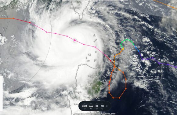
In particular, one of the storms has made a remarkable 360 degree loop off the coast of the Philippines which is behavior that is rarely seen.
Being fueled by warm waters in excess of 30C, some of the storms have become intense and have reached at least Category 4 on the Saffir Simpson Scale. It is also the peak time for such storms across both ocean basins but what makes this unique is the number occurring at the same time.
North Atlantic Ocean
Hurricane Franklin
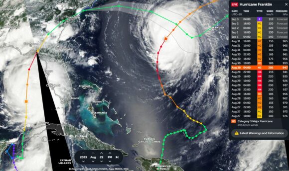
A slow moving hurricane named Franklin has fortunately stayed well out to sea but has delivered a strong swell along the eastern seaboard of the United States. Hurricane Franklin peaked at Category 4 on the Saffir Simpson Scale sustaining peak winds of 230 and 240 km/h between August 28 and August 29 2023.
The storm is now weakening rapidly as it encounters colder waters and an unsuitable environment of the North Atlantic Ocean.
This storm would have only impacted shipping and flights between North America and Europe.
Hurricane Idalia
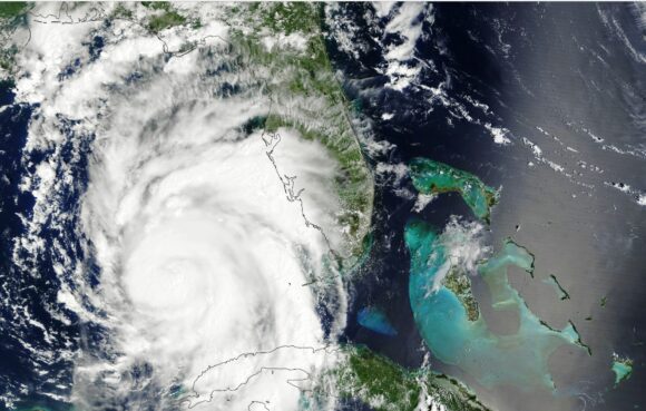
In contrast to Hurricane Franklin, Hurricane Idalia was much different. Spawned by unusually warm waters north west of Cuba within the Gulf of Mexico, the storm had a very short life but moved fast northwards and crossed the coast south east of Tallahassee in Florida. The storm briefly reached Category 4 on the Saffir Simpson Scale but weakened rapidly as it crossed the coast.
The storm had peak winds of at least 215 km/h prior to landfall.
Notwithstanding the extensive disruption that has been caused, there is significant damage within the affected area and flooding. At the time of writing, damage assessment is being undertaken. Death toll and damage impact is not known but it is known that the impact is considerable.

North West Pacific Ocean
Typhoon Saola
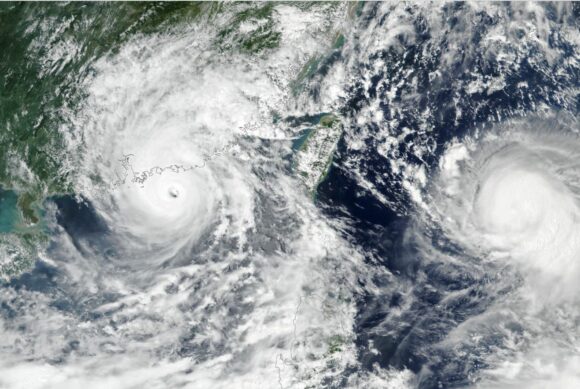
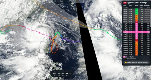
Typhoon Saola is one incredible storm. The system formed north east of the island of Luzon (Philippines) but tracked south west. It formed into a hurricane east of Luzon, brushed the east coast of the island as a strong typhoon (Even reaching briefly Category 4 on the Saffir Simpson Scale), then did a complete 360 degree turn east of Luzon, then changed its path towards the north west.
This made forecasting the movement of the storm very difficult for forecasters. Forecasts were being made that it would impact Taiwan but this did not occur. Instead, the storm passed midway between the Philippines and Taiwan as a Category 4 system. It appears that the storm may have reached or just briefly reached “Super typhoon” status with peak wind gusts greater than 240 km/h during its strongest phase. If it did not, it was a storm that was certainly skirting at the thresholds of a Category 5 system.
The storm has started to weaken as it skirts southern China bringing destructive winds and flooding rains.
This has been a slow moving storm in contrast to other storms and a challenge to forecasters due to its erratic behaviour.
Remarkable, a direct impact on Taiwan and the Philippines was avoided as it was a storm that had erratic behavior off both coastlines.
Typhoon Haikui
The storm is continuing to intensify east of Taiwan and the latest forecast models now appears to suggest that the storm will make landfall across eastern Taiwan as either a Category 3 storm or a Category 2 storm within coming days. Given the topography of the island and the presence of a north to south mountain range across the island, it would be expected that such a storm would drop considerable rainfall causing flash flooding and landslides on exposed areas. Rainfall would also be enhanced on the windward side (eastern side) from such a system.
Tropical Storm Kirogi
Another storm of interest is tropical storm Kirogi which almost reached typhoon status during its strongest phase south of Japan. The storm had sustained peak wind gusts to 60 knots during its strongest phase (Up to 110 km/h). It would have been categorized as a typhoon at this strength had the Australian Tropical Cyclone Intensity Scale been used to determine its strength. Under the Saffir Simpson Scale, its peak strength fell just short of formal typhoon status. The storm is now in a weakening phase south of Japan.
Additional storms
The number of such storms at the same time is rare to see. There are two other storms being watched by forecasters, both of which lie in the Atlantic Ocean being 1 - Tropical Storm Gert and 2 - Tropical Depression 12 at the same time. Fortunately, both storms should not develop any further given their environments.
The above shows how busy it has been across both ocean basins and this is something that is rare to see.
The images attached to the post show the respective storms taken from:
- CIMSS.
- Zoom Earth NASA.
- National Weather Service USA.
- NASA for the images of Hurricane Idalia and Typhoon Saola.
