The most recent rain event impacting northern Victoria is unusual as the area generally endures a hot dry summer with low summertime rainfall. The rain event of Sunday and Monday 7 and 8 January 2024 is significant as some areas have now received two major rain and storm events during the first 10 days of 2024.
While this event is significant, there are areas that have missed out completely and to date, a normal January still prevails.
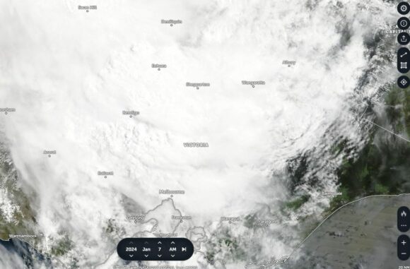
During Sunday, a significant weather event brought thick cloud and sustained rainfall across a region stretching from Kerang to the north (Mallee Region), south east through the Northern Country and areas further south including the following towns and cities and regions:
- Shepparton City (Northern Country or Goulburn Valley).
- Benalla (North East Victoria).
- Seymour (Lower North East Victoria).
- The highlands of North East Victoria.
- Melbourne City and areas further east.
- Gippsland region (East).
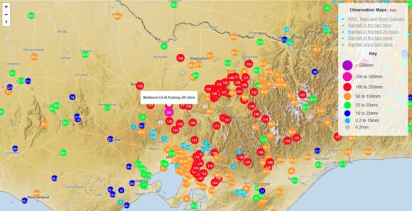
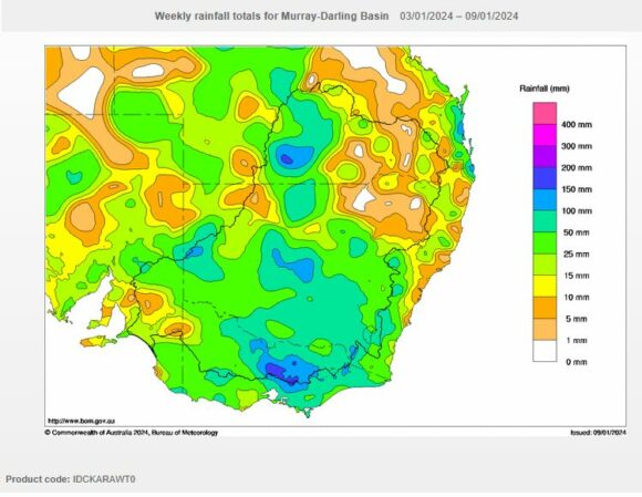
As shown, weekly rainfall accumulations for the period Tuesday 2 January to Tuesday 9 January 2024 shows that rainfall topped 200 mm (Mollisons Creek Pyalong - 201.2 mm) with totals between 100 and 150 mm being common.

Some high 24 hour rainfall totals during the most recent event for the 24 hour period to 9 am Monday 8 January 2024 include:
- Puckapunyal - 121.2 mm.
- Kilmore Gap - 95.6 mm.
- Bendigo - 91.8 mm.
- Coldstream - 76 mm.
- Kerang - 56.8 mm.
Combined with the earlier event, it is revealed that for the first 10 days of 2024 (January), some high rainfall totals have occurred including:
- Coldstream - 159 mm.
- Kilmore Gap - 154 mm.
- Bendigo - 126.6 mm.
- Kerang - 126.1 mm.
- Benalla - 84 mm.
As alluded to earlier, January is usually a dry month across the affected regions and in some northern areas, a Mediterranean climate generally prevails being a climate that typifies hot dry summers with low summertime rainfall.

As a result, flooding has occurred with the worst affected river being the Goulburn River at Seymour (The flood peak has since moved north). The flood peak at the time of writing is approaching the regional city of Shepparton in northern Victoria. There has also been flooding along the Loddon River but not as severe as that along the Goulburn River.
Perhaps the most significant event of all given where this occurred is that the rainfall has occurred during an El Nino year making this event highly unusual for the region.
Attached to the statement are:
- The Cumulative rainfall figures for the affected region for the week ending Tuesday 9 January 2024.
- The cloud satellite picture of Northern Victoria showing the dense cloud affecting the region (NASA Earthview Sunday 7 January 2024).
- The Water and the Land cumulative rainfall plot which clearly shows the region of Victoria that received the most rainfall.

The feature image attached is a photo of a recent storm chase around Braidwood New South Wales. It provides a reasonable idea of the conditions that prevailed across the affected region of Victoria during the period.
