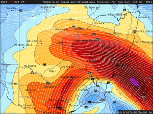
 DPs have improved here overnight with solid 18-20s throughout the Northern Rivers. Actually Yamba has nearly 24. Northerly winds blowing. Sky has a moisture haze storm day look to it.
The first upper trough moves through this afternoon destabilsing the region. Shear is reasonable and better around the Grafton area so will probably target there at first. At 30/20 CAPE is over 2000 but we'll see.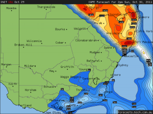
There is another upper trough after midnight so could expect to see more showers or perhaps storms then as well.

Warnings are already out for the Hunter vicinity. A complex of storms must already be achieving severe limits. Storms are widespread and fast moving in the region.
Regards,
Jimmy Deguara
Wallsend and the lower Lake Macquarie have a complex storms coming through at midday
See : 128km Radar Loop for Sydney (Terrey Hills), 22:00 29/10/2011 to 02:00 30/10/2011 UTC
We had a great lightning show here in Ballina
Chased down to Grafton area yesterday and caught the early storm that developed near there. Structure was nice and it appeared like a decent barrage of hail would have fallen WSW of town. I heard a lot of thunder but did not see much lightning from this one.
It weakened just south of Grafton but still managed fling out a microburst of hail 1 to 1.5cm diameter. A few branches fell off trees but winds were not severe.
The flanking line was impressive.
Had to wait a couple of hours for the upper trough and the next storms to move into the region from the Northern Tablelands. It looked messy over the ranges but started to take off as it hit the better moisture.
An LP type structure formed to my NW ahead of the main line. This went on to become the Whiporie supercell that I drove through after the first lot of lightning.
The lightning just kept getting better and better as the line approaching. The CGs were punching ahead of the shelf cloud structure.
Of course the rain hits as it’s the best – so had to bail. Flangs hit all around. The rain was crazy, the sky became like night even though it was only 6pm EDT. 20ks northward along the Summerland Way the situation had eased a bit… sort of. A tree fell across the road in front of me then hail started briefly at Whiporie, before a heavier fall 40ks south of Casino. The rain finally stopped then what sounded like a golf ball sized hail stone hit the car roof, then all quiet. Lightning flicked just behind me through the trees. Driving a little faster than normal I met up with Jason just east of Casino. The storm looked like an HP supercell at this stage though it did not stay organised for long. Lightning was just incredible – countless large CGs punching in front of the clouds.
We stayed until the rain hit then drove to my place at Mcleans Ridges to catch the lightning as the storms passed to the north. Jase got some great shots of all this.
Grafton radar loop. Supercell forms NW of Grafton before 06z.
See : 128km Radar Loop for Grafton, 00:00 30/10/2011 to 11:00 30/10/2011 UTC
Hey Michael great pics!!! Me and Dan chased that shelf as well but only to the north of Grafton. Great to see the structure of the first Grafton storm, we only saw the back end of that one. We also observed that LP structure just in fornt of the line. I assume that was a right moving split, while the left side went on to become the supercell that tracked up to whiporie?
Will post some pics up soon :)
Hi Kane, going by radar – as I did not observe that storm at all times – it formed in isolation ahead of the line coming off the NTs and then tracked NE to NNE – a left mover, no split.
MB
Ah yes looking over the radar again it dosn’t split, I was confused by that small echo that gets drawn into the line just a few frames before the line hits Grafton at the time I thought it split off and thats what made the LP structure :)
Hi All,
As promised here’s a selection of pics from yesterdays chase to Whiporie-Casino-MB’s house. AsI mentioned in an earlier post I was unable to leave home until after 430pm. I spent the whole day stewing on whether I would miss out on anything that formed, as it turns out my late departure was a blessing in disguise. Decided to target an area just North of Whiporie as I know of a good vantage point there. In transit the skies continued to darken and when I finally reached my vantage point I stole a quick glimpse at the sky to my SW and muttered a few expletives at what I was seeing. What looked to be a well organised Supercell was to the west of my position with powerful CGs continually pounding the earth. It had a nice inflow band stretching off to the NE and after reviewing my pics at home later ( clicking through them in quick succession) there was definite rotation.
Another unusual yet amazing looking cloud sprung up just in front of the cell and just seemed to get gobbled up by the beast.
After contacting MB to see where he was at (at the time he was getting pounded with CGs and hail) I decided that my best option was to head North to get ahead of the cell and set up near Casino and wait for it to come to me. During the drive the sky was continually being lit up by the powerful bolts and Casino couldn’t come quick enough!!! Once I arrived I took a quick look at the sky to see where the bolts were occurring and then set up to witness one the most awesome late afternoon CG barrages I think I’ve ever experienced whilst chasing. Here’s a selection of just a few of my favourite ones. I’ve since counted 36 keepers which can be found in the album link at the bottom of report.
Eventually the chasers’ enemy, rain, forced a hasty retreat back towards Lismore and then eventually onto MBs house. Again the the lightning was like a strobe light going off and was near continual. Got set up at MBs and no sooner had I clicked on the 50mm and started shooting a bolt landed just in frame to the West. Was then treated to another right in front of our shooting position down in the valley. After these two things got obscured by rain and it was a near hopeless situation to be shooting in.
Got home to review my weather obs for the cell and was shocked to see that 26mm had fallen from the storm with a peak rain rate of 168mm/hr, my highest rain rate recorded yet.
Anyway hope you enjoy and thanks to everyone else for their pics and reports, its awesome that we have a vast network of weather people who are able to share their perspective of storms whether that be through pics or general reporting. Keep up the good work guys!!!
Full set of pics from the day can be found here
Cheers Jason
this is the storm that developed up towards lismore/casino.
The rest is the line which came through Grafton with all the awesome cg’s.
Kane hardie and myself travelled up to grafton from coffs round about 3:30pm got there about 4:15 then waited around for about an hour when the big storm hit kane got some craker shots include a great movie of us shooting


Got the video up now on youtube.#
http://www.youtube.com/watch?v=fFB5mHrqJ1c
Hi Michael et al,
Nice storm structures from this event – nice HP to top it up.
Did anyone chase the Mid-North coast events earlier in the day? I could not believe how it simply just produced storms at will as the subtle wave came through.
Regards,
Jimmy Deguara
Hi Jimmy,You probably already saw but yes I did! Got onto the Coolongolook supercell with my gf which distinguished a nice low wall cloud (mostly behind the hills) and inflow band before giving 4-5cm and more dents to my car. Unfortunately managed no photos of the structure at all due to the ridiculous amount of trees in the region, however the BSCH Bonny Hills Cam captured a similar structure on a separate storm. We got the back end of this one too with 2-3cm hail and ridiculously heavy rain causing flooding at Kew. Thought I may have got lucky on another storm west of Walcha later which left moved, however by the time it got to me it had weakened substantially and exhibited only a bit of an RFB which wasn’t worth taking pics of.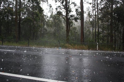
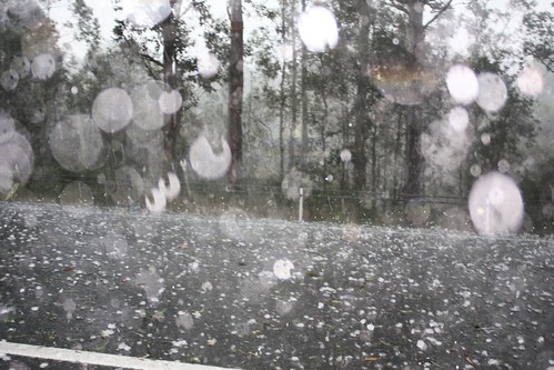
 A couple from the Bonny Hills cam
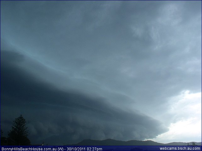
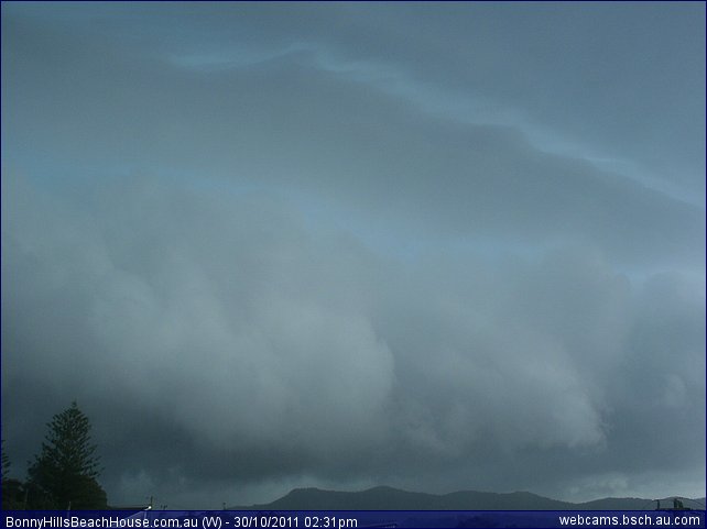 This second one exhibited similar structure to what we saw once on top of us.Fun day!
Hi Ben,
Nice hailstones – obviously you were in the core. Based on the report to the Bureau, I had a feeling it was from chasers – not kuch happens in the town of Coolongoolook!
Do you have any of your own pictures of the structure? This storm system did occur relatively early with one of those 03Z finish events! There are some photographic opportunities east of the main highway.
I know the north coast got stuff later but relatively late.
Regards,
Jimmy Deguara
Hi Jimmy I have no photos of my own of the structure :( I am not aware of any views around there. I tried going west of the highway and found an alright view at some point, however I was too far south to see anything substantial. So instead, I set myself up for a corepunch to make it a bit more exciting!
Hi Ben,
The storms did take off too early – have seen this happen a few times before in the Hunter region teamed with a an approaching change.
I did not check earlier models. Could easily have chased the storms after all.
Regards,
Jimmy Deguara