A blocking high pressure cell located over the Tasman Sea and a hot airmass concentrated over Southern New South Wales, South Australia and much of Victoria has resulted in an early Autumn heatwave or March hot spell unfolding across affected southern areas.
It has been an unusual summer for much of Victoria as parts of the state experienced a cool December, a cool and wet January followed by a hotter and drier February. Much of Southern Victoria has missed out on any substantial heatwaves or sustained bursts of heat this season. The event will most likely be the last burst of summer heat for the 2023/2024 season.
This is certainly the strongest burst of heat to occur across southern areas of the state of Victoria.
During the period leading up to this event, there were at least 3 to 4 days where maximum temperatures across northern inland regions of the state reached at least 32C to 37C especially around Albury / Wodonga, Echuca, Mildura and Swan Hill (All along the Murray River).
On Saturday, a strong burst of heat began to impact Southern Victoria resulting in some of the highest maximum daytime temperatures being recorded for this season. For example:
Saturday 9 March 2024
Melbourne region
Avalon - 40.3C - (It did reach 41C on February 13).
Melbourne Airport - 38.5C - (It did reach 39.7C at the airport on February 13).
Essendon Airport 38.4C - (It reached 38.3C on February 4 and 38.1C on February 12).
Geelong Racecourse - 39.8C - (It reached 40.1C on February 13 and 22 but such heat only occurred on 1 day with cool changes occurring on the following days).
Ballarat 36.6C (It reached 36.3C on February 4. As such, March 9 is the hottest day this season.)
- Nhill 39.9C.
- Hopetoun Airport and Warracknabeal 40.1C.
Hoptoun - Given location, summers are expected to be hotter than at coastal locations.
Warrnambool - 40C at 2.30 pm.
The heat has only clipped southern New South Wales being on the edge of it where maximum temperatures of 35C to 37C were common. The worst of it has been to the west and southwest of this region.
Adelaide and Southern South Australia
Unusual weather circumstances resulted in the following for the day for Adelaide:
- 12 midnight - 27.1C.
- 4 am - 30.2C.
- 7 am - 28.1C.
- 46 am - 37.7C the maximum temperature for the day.
Until this event, it had been a relatively cool summer for Adelaide and such high temperatures above 38C had only been recorded on at least 2 to 3 days this season. For Adelaide, this is the strongest burst of heat for the season.
Maximum daytime temperatures topped 40C at a few locations such as Gawler (40.2C) and Murray Bridge 41.4C.
Sunday 10 March 2024
It reached 40C again at Warrnambool, being 40.5C at 2.52 pm just prior to a south west wind change giving the city two consecutive days above 40C for March. Other high temperatures include:
- Sheoaks - 37.8C.
- Laverton - 38.2C.
- Mortlake - 39.3C.
- Dartmour - 39.6C.
- Avalon - 40.0C
Most Western districts of the state saw maximum daytime temperatures reach 36C to 39C.
This is the second day where maximum daytime temperatures have reached up to 40C somewhere across the affected regions.
Southern South Australia
Similar high daytime temperatures of 38C to 41C have been common across the southeast and areas close to Adelaide with 41C being reached around Cummins, Hindmarsh Island, Keith West, Mt Gambier, Parafield, Port Augusta and Stenhouse Bay.
There were numerous towns and localities where 40C was reached including Edinburg (Adelaide), Naracoote and Port Lincoln.
Monday 11 March 2024
The third day of the hot spell has seen widespread heat occur again but maximum temperatures across some areas were slightly down on those of Saturday and Sunday.
Across Melbourne, maximum temperatures ranged from 32C to 38C which was slightly down from what was initially forecast. The highest maximum temperatures were:
- Avalon - 38.1C.
- Geelong Racecourse - 37.7C.
- Melbourne Airport - 36C.
Across Southern Victoria, Monday was the last day of this hot spell due to the passage of a cooler change during Tuesday.
For Monday, maximum daytime temperatures ranged mostly between 35C and 40C across affected western regions. It was cooler across eastern areas and the north east not under the influence of the hot north west winds with 31C to 35C being common place away from the ranges.
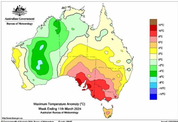
Port Fairy was the hottest location with the maximum temperature reaching 40.4C. Several centres had a maximum of 39C or higher including Dartmoor, Portland Airport, Walpeup and Warrnambool.
A maximum of 38C or higher was reached at Casterton, Hopetoun and Warracknabeal.
Southern South Australia
Maximum temperatures ranged from 36C to 41C across Adelaide including:
- Roseworthy - 41C.
- Pallamana - 40.6C.
- Edinburg - 40.1C.
- Adelaide Airport - 38.2C.
Across southern South Australia, many localities experienced 38C to 41C with 42C at Ceduna being the highest recorded.
Certainly, this has made it the strongest burst of heat for the spring summer season across the southeast and southern populated areas.
However, this is not the case across northern areas and desert regions where such heatwaves have been commonplace and a feature throughout much of summer.
Tuesday 12 March 2024
Across southern areas of Victoria, the heat released its grip following the passage of a cool change, however this was not the case across northern regions where maximum temperatures again soared to at least 38C or higher including:
- Yarrawonga - 38C.
- Kerang, Hopetoun Mildura and Swan Hill where 39C was recorded.
- Walpeup - 41C.
Southern South Australia
Within areas not impacted by the cool change such as the Murray District, Northern Agricultural District, Northern Pastoral districts, maximum daytime temperatures ranged between 36C and 41C. The cool change will have less of an impact the further north one travels and high 30s and low 40s will continue. The continuing heatwave will be impacting mainly desert and remote regions of the state while southern areas will start to cool down.
Attached to the post are:
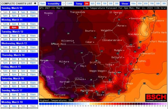
- A sample maximum temperature forecast for Monday 11 March 2024 showing areas most impacted by the heat (BSCH).
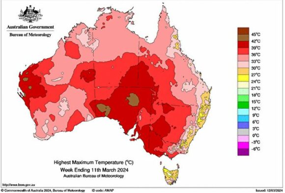
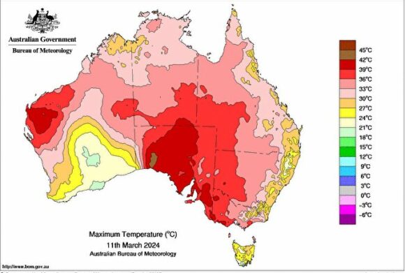
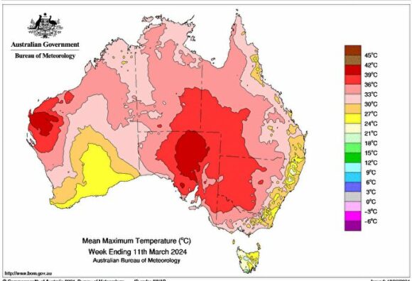
- Various maximum temperature plots produced on the Water and the Land site. In particular, there is particular emphasis on Western and Southern Victoria and much of Southern South Australia for this event.
- The feature image shows a sunset over Western Sydney of recent times but gives an excellent indication of what has been occurring over affected regions of Southern Australia.
