http://www.extremestorms.com.au/flooding-rains-impact-eastern-new-south-wales-1-to-7-july-2022/
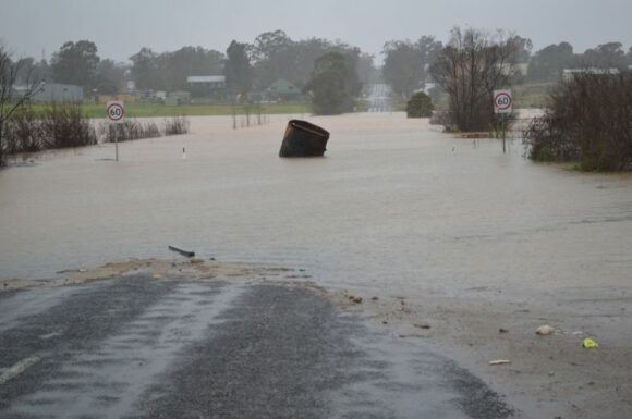
Following a relatively dry June, the month of July was once again wet, especially along coastal New South Wales between Grafton to the north and Batemans Bay to the south. Once again heavy rainfall fell which resulted in the third flood event along the Hawkesbury River in Western Sydney as shown in the attached two images.
Several significant weather events punctuated the month with the most significant occurring between the 3rd and 7th July. The rain and flood events that occurred are covered in earlier posts.
The following can be identified.
1 - Across Sydney, at least 3 wet periods can be identified with the most significant occurring between the 3 and 7 July. During this period heavy rainfall resulted in the third major flood event across the Hawkesbury River basin. Daily maximum rainfall totals topped 101.6 mm at Penrith on July 3 and parts of Western Sydney received upwards of 180 mm of rain on the 5 July including 178.4 mm at Horsley Park, south west of Blacktown.
2 - During the same weather event, heavier rainfall totals fell in areas south west of Wollongong within the Illawarra region.
3 - Heavy rain impacted other coastal areas of New South Wales including Coffs Harbour where 160 mm of rainfall fell on July 6. At Port Macquarie 94.4 mm of rainfall fell on July 6 and 85.2 mm fell on July 7.
4 - During the first 5 days of July, moderate to heavy rainfall impacted large parts of Queensland with such rainfall being unusual given that July is usually dry.
Monthly rainfall totals across much of Sydney exceeded 300 mm and for Sydney city, the total exceeded 400 mm (Total 404 mm on 20 days).
Some incredible monthly rainfall totals for New South Wales for the month of July includes:
- Katoomba (Farnell Road - 595.2 mm).
- Lucas Heights - 647.9 mm.
- Robertson (The Pie Shop) - 698.8 mm.
- Beaumont (The Cedars) - 825 mm.
- Darkes Forest - 875 mm.
As shown in the table below which is updated from the table of June 2022 for the same New South Wales localities, rainfall across coastal centres is impressive.
Sydney (Observatory Hill) 1950 - Total 2,194 mm
Sydney City (Observatory Hill) in 1950 received 2,194 mm which is the current rainfall yearly record for that weather station. That record is now being challenged following the events of July. As it stands on July 31, Sydney Observatory Hill had received 1,942.4 mm for 2022. The weather station only needs to record another 251.6 mm to breach that record. Given that there are 5 months of 2022 remaining and given the current weather conditions prevailing, it is possible that the record could be broken.
Already, there are weather stations and towns that have received more than 2,000 mm for the January to July period.
| SYDNEY REGION | July 2022 | So far for 2022 |
| Parramatta | 338.6 mm on 19 days. | 1,535.4 mm |
| Penrith | 259.2 mm on 19 days. | 1,367 mm |
| Richmond | 207.6 mm on 15 days. | 1,212.8 mm |
| Sydney (Observatory Hill) | 404 mm on 20 days. | 1,942.4 mm |
| Home (Comparison and guide only) | 322.9 mm on 15 days. | 1,388.2 mm |
| NORTH COAST NSW | ||
| Ballina | 154.4 mm on 19 days. | 2,237.4 mm |
| Coffs Harbour | 277.8 mm on 17 days | 2,084.8 mm |
| Dorrigo | 235 mm on 11 days. | 2,272.5 mm |
| Grafton | 80.6 mm on 13 days. | 1,201.2 mm |
| Port Macquarie | 305.8 mm on 14 days | 1,915 mm |
| WHEAT SHEEP BELT NSW | ||
| Albury Airport | 37.8 mm on 8 days | 598.6 mm |
| Dubbo | 58.6 mm on 9 days | 565.8 mm |
| Forbes | 50.4 mm on 9 days | 471 mm |
| Tamworth | 36.4 mm on 9 days | 414.6 mm |
| Wagga Wagga | 18.4 mm on 11 days | 352.2 mm |
During the month, it was identified that a negative Indian Ocean Dipole now features which is expected to enhance rainfall especially across inland areas. Of interest the heaviest rainfall during July and indeed winter 2022 has been coastal with much lighter totals occurring inland.
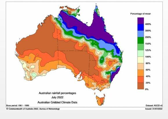
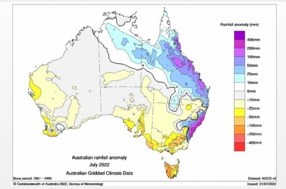
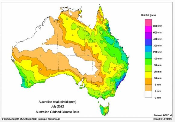
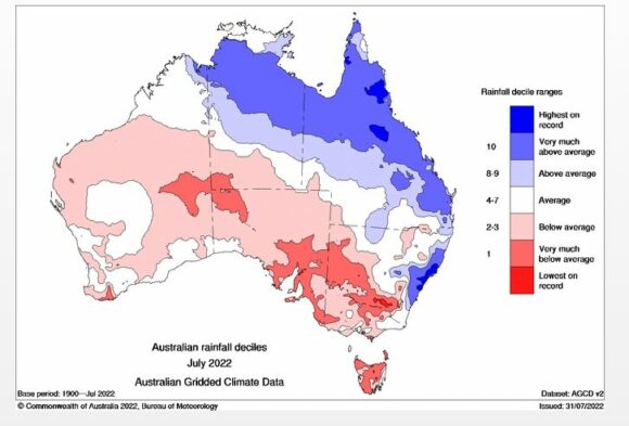
Rainfall for July across many inland areas of New South Wales was well below average as shown in the attached rainfall plots generated from Water and the Land. It is also shown that coastal New South Wales especially between Grafton and Batemans Bay was drenched.
In Queensland, higher than normal rainfall occurred mainly as a result of the event that occurred within the first few days of the month.
Early August Rainfall (New South Wales)
There has since been a rainfall event across large parts of inland New South Wales that has brought widespread 25 to 50 mm falls which would have erased some short term rainfall deficits created during July.
The heaviest falls from this event fell along the spine of the Great Dividing Range, Snowy Mountains, Australian Capital Territory (Canberra) eastern parts of the South West Slopes, Central and Southern Tablelands, North West Slopes and western side of the Northern Tablelands. Some cumulative rainfall totals exceeded 50 mm from this event.
Attached are relevant Water and the Land Plots showing the rainfall for July 2022 to reinforce the discussion above.
Notes
1 - All rainfall and historical rainfall used is sourced from BOM historic data and data from official weather stations.
2 - While I have a rain gauge set up in the rear yard, it is only being used as a guide but it is noted that it is relatively consistent with official figures occurring at nearby Prospect and Horsley Park where official weather stations are established.
