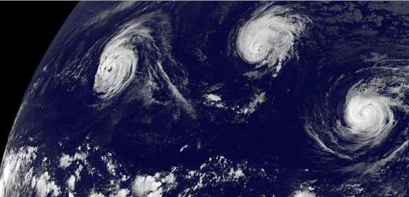
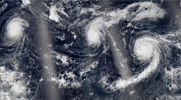
During the past week, a remarkable weather event occurred over waters surrounding Hawaii being a trio of hurricanes (three hurricanes) with each hurricane reaching Category 4 on the Saffir Simpson Scale at the same time. This is the first time that such phenomena has been documented.
The three names storms east to west were:-
1 - Jimena.
2 - Ignacio.
3 - Kilo.
At one stage, the islands of Hawaii were under threat from Hurricane Ignacio. The storm passed to the east of the islands and the threat has now diminished. Generally, Hurricanes Ignacio and Jimena are now weakening as they encounter colder waters, shear and a less favourable environment. Ignacio is expected to become a deep low pressure cell as it tracks north towards British Columbia.
Another storm named as “Tropical Storm Kevin” also formed at the same time south west of Baja California giving four named storms and while this produced intense thunderstorms, this did not develop into any hurricane. This storm is also weakening as it tracks northwards.
This leaves one remaining storm being the westernmost storm. This storm known as Kilo is tracking west across the Pacific Ocean. Initially forming south west of Hawaii in US waters as a hurricane, the storm has tracked so far west that it has entered the north west Pacific Ocean and has been re named Typhoon Kilo.
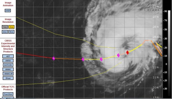
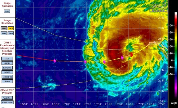
The storm initially reached Category 4 on the Saffir Simpson Scale but weakened as it approached and passed north of the Tropic of Cancer. It weakened back to a Category 1 Hurricane / Typhoon. However, the storm has tracked back south west and as it does so, is now passing over much warmer waters (As much as 31C). Being within a more favourable environment, the storm is expected to intensify and could reach a Category 4 storm again. As at late Friday:-
1 - The storm has winds reaching 80 knots near the core (Approximately 148 km/h).
2 - The storm was located at 23.5 degrees north and 176.3 degrees east.
3 - The storm was tracking back south west at 6 knots (Approximately 11 km/h).
4 - The storm according to the CIMSS Model could sustain winds of 115 knots (Approximately 213 km/h) within 48 hours.
5 - The storm is beginning to track over much warmer waters which would assist in its re intensification.
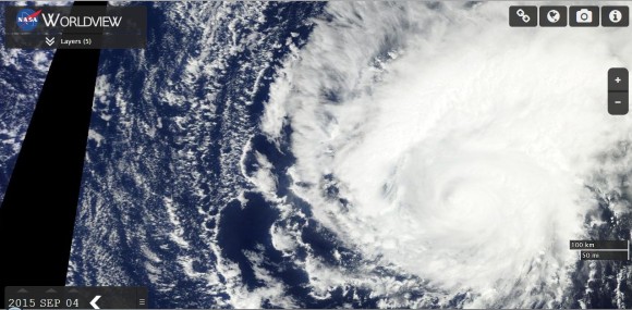
The MODIS Worldview image is showing the storm clearly with substantial convection on its northern and north eastern quadrant. The eye is visible but it is somewhat clouded over. When compared to recent days, the storm has lost part of its structure due to its location but it should reform.
Currently the storm is passing over open ocean and not a threat to any country or population centre. However, should it continue this remarkable path across the Pacific Ocean, then there could be a future threat to southern Japan or Taiwan. This is a remarkable storm given its track and it is now beginning to make an approach to East Asia. This is a very interesting storm given the distance that it has already travelled.
The image of the three hurricanes near Hawaii is from NASA’s Earth Observatory showing the three storms almost surrounding Hawaii. It is a spectacular image and shows the threat that existed near the islands at one stage. Hawaii was fortunate as none of the storms made a close approach to the islands.
CREDITS
Images to support the post are acquired from:-
1 - NASA “Earth Observatory” dated September 2 and August 30 2015 (For Images 1 and 2).
2 - MODIS Worldview with overlays (NASA) dated 4 September 2015 (For Image 3).
3 - CIMSS 4 September 2015 (For Images 4 and 5).

