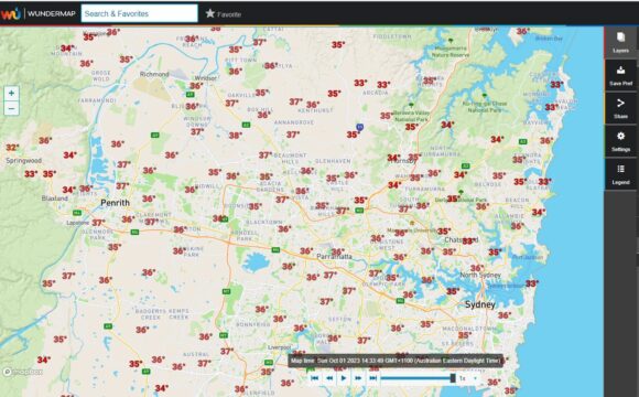
As shown on the attached "Wundermap" at 2.35 pm for Sunday afternoon, the whole of Sydney was experiencing temperatures of between 33C and 38C. The hottest locations were around Penrith where 37.3C had occurred.
This was certainly forecast and expected.

Unlike Saturday, the heat spread to the coast and thus 35C and 36C temperatures were being experienced even within the coastal suburbs. The sea breeze had no chance to penetrate the coastal suburbs.
Similar conditions were experienced across large swathes of the western and northern inland regions of New South Wales and even along the South Coast of New South Wales.
At 3 pm, the following official maximums were being reported across weather stations:
Sydney
Penrith - 37.3C.
Sydney Airport - 36.9C.
Richmond - 36.7C
Horsley Park - 35.8C
Sydney Observatory Hill - 35.6C.
While this is a significant event, this is not a record October high temperature for anywhere across Sydney. Maximum daytime temperatures reached 40.1C during the afternoon of October 21 1988 across parts of Western Sydney. As far as available records will permit, it is possible that this event of 35 years ago could be the hottest October day officially recorded anywhere across the city.
Elsewhere across New South Wales
Brewon AWS - 37.3C. (North West New South Wales).
Bourke - 37.7C. (North West New South Wales).
Wilcannia Aerodrome - 38.2C (Western New South Wales).
Tibooburra - 36.9C. (Far North West New South Wales).
Moruya - 36.5C. (South coast of New South Wales).
Except for areas along the southern border with Victoria where a weak cool change had passed through, the heat was generally widespread across the state.
For Sydney and the South Coast, the heat eases during Monday following a weakening southerly change. There is another burst of heat for Tuesday just ahead of a more significant weather change coming through during Wednesday into Thursday that will end the latest burst of spring heat.
