During the weekend 11 and 12 September 2021, maximum daytime temperatures reached 30C for the first time this spring / summer season for certain areas of Sydney.
On Saturday 11 September 2021, it reached 30.4C at Penrith followed by 30.2C at the airport weather station. Most other parts of Sydney enjoyed maximum daytime temperatures of between 28C and 29.9C.
On Sunday, daytime temperatures were slightly higher and the first 30C temperatures for the season were more widespread across the city. This includes:-
Airport - 31.5C.
Penrith - 31.2C.
Bankstown - 30.3C.
Sydney Olympic Park - 30.2C.
City - 30.1C.
Where 30C was not reached, maximum temperatures reached at least 28C to 29.9C.
(Temperatures quoted are taken at 2.30 pm Sunday afternoon.)
Such temperatures are occurring ahead of another strong cold change crossing Victoria and New South Wales. Unlike the two previous changes, the change is not producing much rainfall. A significant rain event is not forecast however there is a strong temperature contrast before and after the change.
For example, at 1.30 pm on Sunday afternoon, it was only 14.4C at Albury, 16.9C at Moruya Airport, but 25C at Ulladulla. The change was approaching Ulladulla at the time.
Similar high temperatures were also recorded across the Hunter Valley, North West Slopes, and along the north coast of New South Wales.
Across Sydney, hot dry north west winds have filtered across the city and with clear skies, there has been much heating.
Following the cold change, temperatures will plunge and coastal showers will dominate for the next 2 to 3 days.

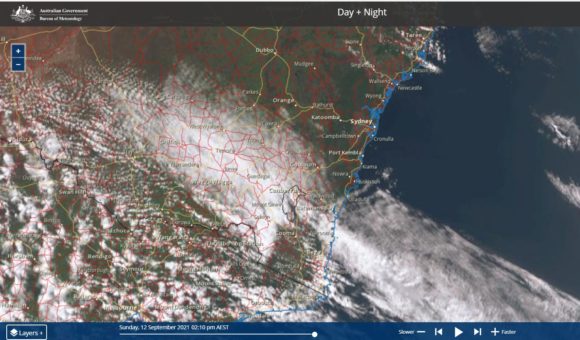
The Himawarri Satellite image of New South Wales of 2.10 pm Sunday afternoon shows the location of the change. It is a state of two halves with very warm dry conditions ahead of the change and the narrow cloud mass and cool to cold conditions following the change and cloud mass.
