https://www.extremestorms.com.au/hurricane-milton-expected-second-major-hurricane-to-strike-florida-6-to-9-october-2024/
Milton reaches Category 5 on the Saffir Simpson Scale
As identified in a previous post of which the link is attached above, a new but more powerful storm developed within the Gulf of Mexico which reached Category 5 on the Saffir Simpson Scale at peak intensity.
It is also identified that the storm exceeded initial model predictions given such a favorable environment that existed to allow its formation.
The wider region is still reeling from the effects of Hurricane Helene and the storm comes hard on the heels of that event. The cleanup and recovery from that event is underway but it will take months and many years for a complete recovery.
Hurricane Milton began its life as a tropical storm on Saturday 5 October and reached Category 5 on the Saffir Simpson Scale on Monday 7 October. Forecast models generally had consensus that the storm although somewhat weakened would impact a major metropolitan city of Tampa / St Petersburg or an adjoining city called Sarasota just to the south.
At peak intensity at Category 5, the storm sustained winds at the core of at least 175 miles per hour (282 km/h). The southern edges of the storm clipped the northern coastline of the Yucatan Peninsula (Mexico) and weakened slightly as it underwent an eye replacement cycle.
At its closest point, the eye of the storm was only 100 km offshore from the coastline of the Yucatan Peninsula and thus communities along that part of the coastline had a narrow escape from the full intensity of the storm.

The problem identified is that the waters of the Gulf of Mexico are unusually warm being around 29C to 30C. Coupled with low shear, Milton had the perfect environment to form and was able to build perfectly. Additionally:
- The eye prior to its replacement was barely 4 miles across (6.4 km) which was tiny.
- The storm remained compact.
- Late Tuesday (Australian Eastern Standard Time), it was noted that the storm began to turn more to the northeast and by 12 midnight, the storm had begun to accelerate to 12 miles per hour (20 km/h). The final journey to the west coast of Florida had begun.
Heavy rain, major storm surges, flooding and hurricane force winds were being forecast for major cities of Tampa / St Petersburg all the way south to Fort Myers and evacuation orders were in force. It was also noted that:
- Local fuel stations were being closed.
- I75 being the major highway north was experiencing very heavy traffic and movement was slow.
- Evacuation centres were already in operation.
- A major attempt was being made to have all debris from the previous hurricane removed until such time that it would become too dangerous to continue the cleanup work.
- The National Guard was ready to coordinate emergency responses.
- Compulsory evacuation orders were in place for the outlying islands being those areas that were expected to be hardest hit by the storm surges.
- Electricity grids and sewerage treatment plants were expected to be switched off for the duration of the event.
- Potentially 3 to 4 million residents were under some form of evacuation orders or related emergency orders.
- Storm surges of 3.3 metres to 4.6 metres were being forecast.
As at Wednesday morning, (AEST), the storm was located approximately 700 km from the Florida coastline with models showing a clear and defined eye, a Category 5 storm (Re intensified again) with peak winds to 145 knots at the core (Approximately 262 km/h) and a northeast movement. CIMSS projected landfall barely to the south of Tampa / St Petersburg but north of Sarasota.


As at 4.30 pm (CDT), the storm according to the National Weather Service and via aircraft measurements was producing winds at the core of approximately 165 miles per hour (Calculated at 265.5 km/h) which was close to the CIMSS forecasts and ensembles. A minimum central core of 905 MB was verified. The storm was moving east northeast at 15 km/h and a landfall near Sarasota was anticipated.
Landfall at Siesta Key (Sarasota) at 8.31 pm
After reaching Category 5 on the Saffir Simpson Scale again, the storm began a slow decline as it neared the Florida coastline. A cold front to the north began to influence the storm and steer the system towards Sarasota and the west coast. The size of the storm enlarged and at 11.31 am (AEST) or 8.31 pm local time, the National Weather Service confirmed that landfall had begun. In particular:
- Landfall was announced 5 miles (8 km) west of Siesta Key at 11.31 pm as a Category 3 storm.
- The main precipitation shield from the storm remained towards the north of the eye and thus Tampa and St Petersburg cities were hard hit by the rain squalls.
- The main storm surges occurred to the south of the eye.
- At least 15 tornadoes were identified with one reaching EF3 earlier that day. At least 127 tornadoes warnings were issued across Florida including those near Fort Lauderdale.
At landfall, verified wind gusts included:
- CM Station Venice (Egmont Channel) - Winds of 100 miles per hour being 161 km/h were recorded.
- Albert Whitted Airport in St Petersburg - A Weather flow weather station recorded a wind gust of 93 miles per hour or 150 km/h.
- Skyway Fishing Pier - A weather station recorded a single peak wind gust to 102 miles per hour or 164 km/h.
At landfall, it was reported on Fox 13 (Tampa and Orlando) that 100,000 customers lost power and power flashes were visible on nighttime images across the cities.


By 9 pm, at least 800,000 residents across the wider region were now without power. By midnight local time, the figure increased to greater than 1.5 million residents.
Once landfall was complete, the storm weakened to a Category 2 storm with the primary rain shield progressing towards Orlando inland.
Landfall occurred at night but earlier than expected and thus any damage assessment of what has occurred cannot be made until after daybreak. At the time writing:
- The level of storm surges while slightly less than expected was still around 3.3 metres (10 feet).
- Flooding was being identified across Tampa City from heavy rainfall which has amounted to a few hundred mm. It is suggested that rainfall may have reached 400 mm at isolated locations.
- There are flash flood emergencies in place.
- Power is being lost around Tampa City with TV cameras showing transformers blowing and regions of the city going into darkness.
- Trees were down across Gainsville.
- A crane has fallen from a construction site in the St Petersburg city centre. This is a major event but at the time of writing, nothing can be done until daybreak.
This is shaping as a major catastrophe which will now play out over the next days and weeks.

I have attached certain models and images of the storm including radar images from the National Weather Service just prior to landfall.
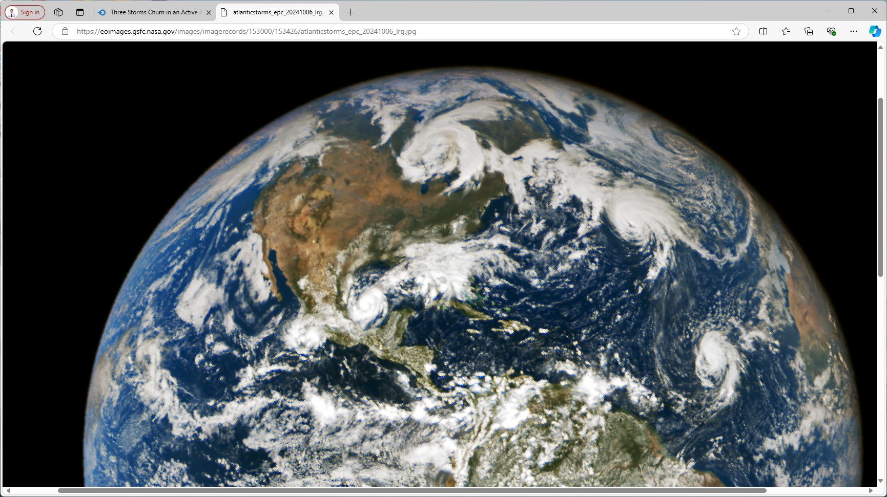
The incredible “feature image” of the post is downloaded direct from NASA via “Image of the Day” dated Tuesday 8 October 2024. Hurricane Milton is shown within the southern gulf. The satellite that took this image was located 1.6 million km from Earth at the time the image was taken.