As alluded to in recent posts, Australia as a continent often experiences some of the most varied weather found anywhere in the world. For the past week ending Saturday 9 December 2023, that statement has certainly rung true.
At the present time this country is enduring some incredible weather extremes from significant thunderstorm events, an intense inland heatwave and now a tropical cyclone that is complicating matters off the north east coast of Queensland. This storm is posing a threat to coastal towns between Mackay to the south and Cairns to the north.
The sequence of events are as follows:
1 - Inland heatwave
Over the past week, a significant heatwave has impacted much of the inland but generally most of the capital cities and coastlines have been spared the worst of it. The worst of the heat has impacted inland regions of Western Australia, Northern Territory, South Australia, south west Queensland and inland northern and western Queensland.
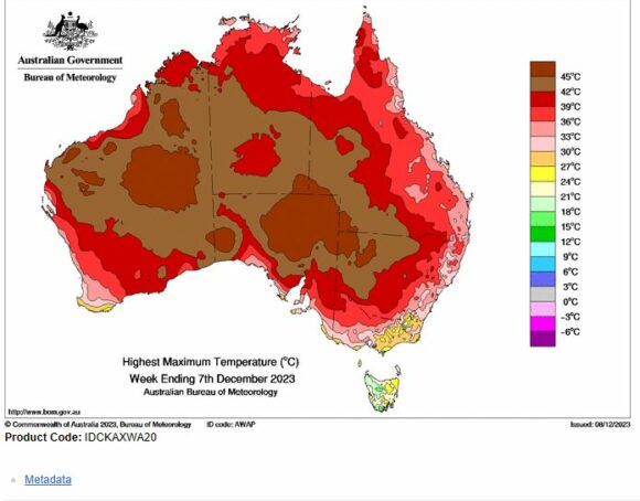
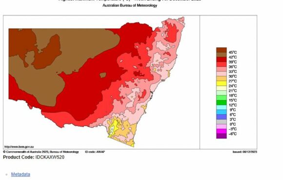
In New South Wales the worst of the heat has not made it further east and south of Narrabri / Dubbo / Parkes and Griffith. All those places west and north of the towns / cities mentioned have sweltered.
Short bursts of this heat event have reached at least into Western Sydney limited to Tuesday, Friday and Saturday. Maximum daytime temperatures overall have been lower than those experienced at such places as Bourke, Broken Hill, Menindee and Tibooburra. In New South Wales, the bulk of this event is mainly impacting regions that are sparsely populated.
Some of this heat has also reached into the Upper and Middle Hunter Valley region but the lower Hunter has been spared.
It is interesting to note that barely any of this has penetrated south into Victoria except for a portion of the state around Mildura in North West but even then, only two hot days were recorded here being 38.2C and 38.7C on the 4 and 5 December before cooling down to 36.1C on the 6 December.
Some of the maximum daytime temperatures within Western New South Wales have exceeded 44C and forecasts clearly show the inland heatwave to continue to at least the 14 December.
The table below shows what has been occurring at least across the inland areas of New South Wales.
| Maximum daytime temperatures for duration of heatwave - Days above 38C | |||||
| Town | 4 December | 5 December | 6 December | 7 December | 8 December |
| Balranald | 38C | 41.5C | |||
| Borrona Downs | 37.6C | 42.3C | 43.4C | 44.8C | 43C
Minimum temp 30.3c |
| Bourke | 39C | 42.5C | 43.8C | 41C | |
| Broken Hill | 38.1C | 43.4C | 41.7C | 43.4C
|
43C
Minimum temp 28.8C |
| Cobar | 40.1C | 42.8C | 43.7C | 42C | |
| Condobolin | 39.3C | 40.9C | 38.3C | 40C | |
| Dubbo | 36.9C | 36.9C | 40.6C | 39.9C | 40C |
| Fowlers Gap | 38.2C | 43.1c | 43.6C | 44.7C | 43C
Minimum temp 31.3C |
| Griffith | 40C (Southern limit of heat) | 39C | |||
| Gunnedah | 38.8C | 39.6C | 37C | ||
| Hay | 43.2C | 36.7C | 38.5C | 41C | |
| Menindee | 38.5C | 43.5C | 40C | 43.2C | Not available |
| Tibooburra | 42C | 43.5C | 45.2C
Minimum temp 31.4C |
43C
Minimum temp 31.2C |
|
| White Cliffs | 37.9C | 43.2C | 44.9C | 45C | 42.7C
Minimum temp 29.6C |
| Sydney
Badgerys Creek |
37.7C | 39.6C | |||
| Sydney
Penrith |
38.7C | 40.6C | |||
| Sydney
Richmond |
38.1C | 41.1C | |||
One feature of most heatwaves is that occasionally, overnight minimum temperatures do not drop below 30C. The table above is showing this occurring again at certain locations during this event.
The heat has reached at least into Western Sydney but in two short bursts. Of course, the first 40C temperatures of the summer were recorded at least for Penrith and Richmond on Friday 8 December 2023.
Saturday 9 December is becoming a significant day as the heat has reached further into Sydney. By 12 noon, the temperature has topped 40C at Badgerys Creek, Horsley Park, Penrith, Richmond and Sydney Airport. All those localities and suburbs within the vicinity of the weather station sites are experiencing similar temperatures. In many areas, this is the first time in 3 years that this has occurred.
2 - Thunderstorms
The feature image attached to this post is taken at Doonside looking west showing a lightning strike from a thunderstorm that passed to the west early Sunday evening 3 December. That storm was the last in a series of storm events that impacted Western Sydney Wednesday, Saturday and Sunday. This storm was lightning active as it tracked from the south west to the north east and contained hail.
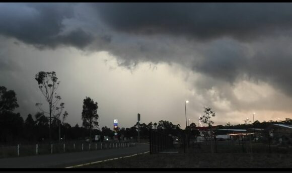
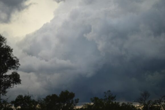
Incredibly the conditions across Western Sydney went from one of thunderstorm events to heat in the space of 2 days.
Other events
A thunderstorm event at Albury / Wodonga on the New South Wales Victoria border Friday afternoon brought gales of 98 km/h at the airport enough to cause damage across the region.
Friday afternoon, a thunderstorm crossed parts of North West Sydney that brought some cloud to ground lightning but very little rainfall.
South Australia
The heatwave has passed through South Australia with several inland centres experiencing 4 consecutive days of maximum temperatures exceeding 40C with maximum temperatures reaching 46C including:
- Maree - 46.4 C recorded on the 6 and 46.5C recorded on the 7 December.
- Oodnadatta - 46C recorded on the 7 December.
- It reached 45C on 3 consecutive days at Andamooka between the 5 to the 7 December.
A change of events is forecast to unfold with rain and storms set to become a feature over the next few days with forecast models showing widespread 25 to 50 mm rainfall occurring. This is unusual as South Australia is known as being the driest state in Australia. A cut off low is expected to form then stall before weakening between Saturday and Tuesday generating such rainfall.
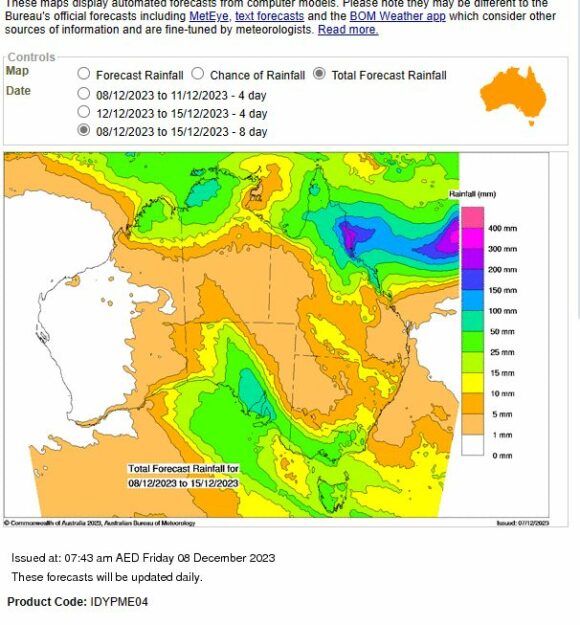
This system is unlikely to spread much into New South Wales.
Tropical Cyclone Jasper
This is a separate storm event but one that is generating much interest given the timing and its behaviour. This storm is unusual for the following reasons:
- Its development and movement is described as sluggish to slow.
- Timing so early in the season.
- Its strength.
Using CIMSS models, and as attached, the storm has reached peak intensity just above Category 4 on the Saffir Simpson Scale. The intensity is relatively similar to that under the Australian Tropical Cyclone Intensity Scale 1989.
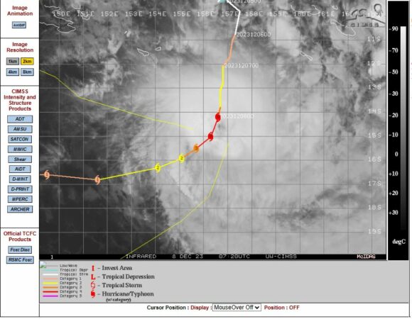
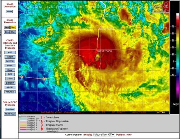
This storm appears to be tracking south west and passing over waters of 27C to 29C. It appears that this storm will weaken as it approaches the Queensland coast. The CIMSS model now suggests a Category 1 storm prior to or at landfall.
The GFS models are suggesting that the storm may make landfall near Cairns Wednesday and Thursday.
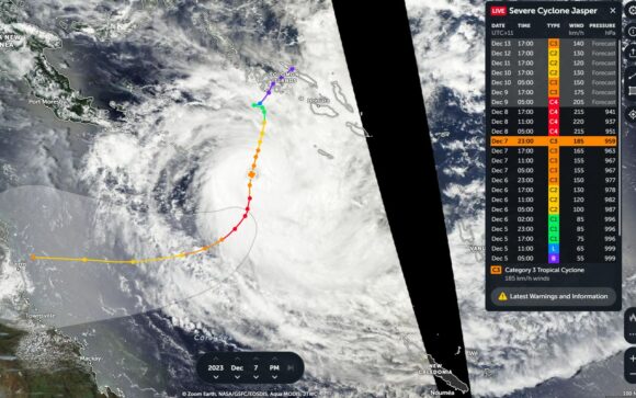
The above shows how variable the weather has been. To further highlight the extremes and at the time of writing, it is raining in Adelaide (South Australia) and Melbourne (Victoria) and temperatures of 15.6C and 17C respectively while it has reached 39.4C at Sydney Observatory Hill.
I have attached various plots showing the above and the photos attached are from recent storms that I photographed.
