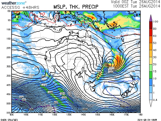
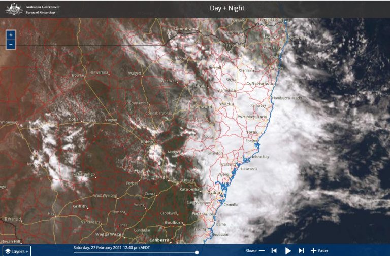
 Models are consistent in placing an another East coast low this time off the NSW north Coast by mid week. Some heavy falls are likely as the system develops and intensifies. Moisture has already been fed into Eastern NSW as a result of the NE airstream over the past several days since the previous east coast low.
This is quite impressive given the past several months were relatively dry across much of Northern and Eastern Australia. The system may last until the end of the week.
Initially, a cold pool located over Victoria is anticipated to be situated over eastern NSW by Monday evening. Coupled with the I feed of moisture, rain should increase with some respectable falls overnight until Tuesday.
The heaviest rainfall should be on the Mid North Coast of NSW with falls up to or exceeding 100mm by Wednesday morning as the low intensifies and becomes situated nearer the coastline. More rain will persist into the week but much depends on the relative position of the low pressure system.
Update 26th August 2014
Radar shows that rain and storms will be headed inland near Sydney which could put some substantial rainfall across the Sydney basin and also the Central Coast.
See : 128km Radar Loop for Sydney (Terrey Hills), 00:00 25/08/2014 to 00:00 26/08/2014 UTC






Another east coast low for the taking. I hope it takes its time to develop so that the gradient does all the work it requires!
Another east coast low for the taking. I hope it takes its time to develop so that the gradient does all the work it requires!
And the event unfolds. Radar shows some substantial rain heading in from the east off the coast near Sydney and the Central Coast! This could mean some heavy rain for Sydney and surrounds.
And the event unfolds. Radar shows some substantial rain heading in from the east off the coast near Sydney and the Central Coast! This could mean some heavy rain for Sydney and surrounds.
Just posted radar – check http://www.extremestorms.com.au/another-east-coast-low-26th-to-27th-august-2014/.
Just posted radar – check http://www.extremestorms.com.au/another-east-coast-low-26th-to-27th-august-2014/.
Ballina hit by flash flooding last night – what's the latest?
Ballina hit by flash flooding last night – what's the latest?
The warning system and the culture of the BoM has to change to something similar of that in the NWS which is far more open to the public.
The warning system and the culture of the BoM has to change to something similar of that in the NWS which is far more open to the public.
This has to be one of the most impressive rain events in some time. Two east coast lows in reasonably quick succession. The second east coast low was slow to develop and intensify allowing in my opinion for an extended event! When people hope for East Coast lows, remember they are usually quick to produce and often take the rain away. I prefer a system like this that took a week for a build up!
This has to be one of the most impressive rain events in some time. Two east coast lows in reasonably quick succession. The second east coast low was slow to develop and intensify allowing in my opinion for an extended event! When people hope for East Coast lows, remember they are usually quick to produce and often take the rain away. I prefer a system like this that took a week for a build up!
Harley Pearman, there has to be some impressive statistics from this event – particularly in the event at Ballina?
Harley Pearman, there has to be some impressive statistics from this event – particularly in the event at Ballina?
I have finally found time in my busy schedule to write this report.
For the 24 hours till 9 am 26/8/2014, the following rainfall figures are presented:-
Bundeena 73 mm. This is a very isolated fall for the period for Sydney and no other Sydney suburb reached this figure. There was a fall of 44 mm at La peruse being the second highest. The other falls across Sydney are not significant.
Wollongong:- The hills west and south west of Wollongong received the highest falls as follows:
Barrengarry – 112 mm (Highest total).
Robertson – 92 mm.
Macquarie Pass – 90 mm.
Avon Fire Tower – 88 mm.
Mittagong – 88 mm.
Fitzroy Falls – 84 mm.
Fitzroy Falls Dam – 78 mm.
Upper Calderwood – 70 mm.
Hampton Bridge – 64 mm.
Bowral – 54 mm.
Moss Vale – 52 mm.
When reviewing the rainfall, anywhere within this small locality received the more substantial falls. Falls were lighter elsewhere.
There was a small area on the South Coast of New South Wales that had slightly less but still reasonable rainfall including:-
Moruya (The Lagoon 71 mm).
Batemans Bay – 68 mm.
Broomen – 65 mm.
Moruya – 51 mm.
This occurred within a very small area centred around Batemans Bay and Moruya for the period.
For the 24 hours till 9 am 27/8/2014, rainfall became more pronounced and heavier as follows:-
Sydney
Best falls include:
Sutherland – 82 mm.
Eastern Campbelltown region – Up to 76 mm.
Bundeena – 75 mm (The second 70 mm plus total in a row).
Minto – 57 mm.
Most of Sydneys southern suburbs received 29 mm to 40 mm.
Richmond and Windsor received 38 mm each.
There is a fall of 57 mm at Katoomba.
Wollongong:- Falls of 25 to 50 mm were common with the best occurring at Fitzroy Falls and Roberton, each with 56 mm.
Mid North Coast:- Heavier falls occurred including:
Comboyne Public School – 172 mm.
Mt Seaview – 141 mm.
Upper Pappinbarra – 98 mm.
Forbes River (West of Port Macquarie) – 95 mm.
Carey Peak (Barrington Tops) – 78 mm.
Moppy Lookout – 74 mm.
Kempsey Region:
Turner Flat – 182 mm.
Boonangah – 131 mm.
Kempsey – 115 mm.
Moparrabah – 109 mm.
Bellinger Valley:
Spicketts Creek and Utungun – 119 mm each.
Coffs Harbour region:
Sawtell – 136 mm.
Toormina – 110 mm.
Middle Boambee – 108 mm.
These represent some of the biggest falls for the day. The more significant falls are centred on the New South Wales Mid North Coast.
For the 24 hours till 28/8/2014, substantial rainfall continued especially on the New South Wales North Coast around the Lismore region. The heaviest falls include:-
Lismore region:
Tuckambil – 182 mm.
Lake Ainsworth – 177 mm.
Alstonville (Lismore) – 175 mm.
Lismore – 168 mm.
Anywhere around the Lismore region received between 150 and 180 mm.
Grafton – Sandstone Hill had 128 mm.
Coffs Harbour – Anywhere from 59 mm to 104 mm.
Bellingen had 123 mm while Dorrigo had 109 mm.
Sydney
Continued scattered showers dropped varying rainfalls including:-
Mona Vale – 25 to 34 mm including 34 mm at Narrabeen.
Homebush Bay 28 mm.
Chatswood – 26 mm.
Blacktown received the highest fall for Western Sydney with 21 mm.
In concluding the topic, it is noted that August started off dry with little rainfall up until August 16. The two east coast lows occurred in a space of 13 or 14 days. What would normally be a drier month for the coast has finished up being a very wet month. August 2014 is in stark contrast to August 2013.
For interest, the nearest rainfall guage to where I live at Blacktown recorded some 161.8 mm of rain for the month, the majority of it occurring between August 16 and August 30 (15 days). Further, during this period, it rained on 14 days.