The first 30C days for the spring summer season has occurred across a significant portion of the state. With this occurring, the transition towards summer is well underway.
A burst of strong westerly winds to the south associated with the passage of cold fronts over Tasmania and Victoria as well as a rare stratospheric warming event over southern areas has contributed to the prolonged burst of summerlike heat.
While not a heatwave in a technical sense, this is a significant burst of early warmth which has not gone unnoticed.
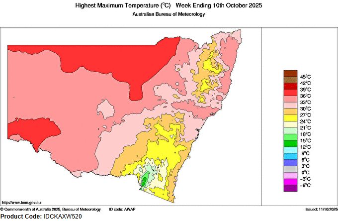
At the time of writing, there have been 5 days over the past week where maximum daytime temperatures have reached into the low 30s across Western Sydney with a maximum of 32.8C being reached on Monday afternoon at Penrith and 32.4C being reached at Horsley Park (Same day).
While such temperatures are common during October, the longevity of the current spell of warmth is of interest.
Across the inland of the state, numerous other centres have also experienced similar or slightly higher maximum daytime temperatures for the same period including but not limited to the following:
- Walgett reached 37C on October 8.
- Wanaaring - It reached 36.8C on October 5 followed by 36.4C on October 6
- Brewarrina 36.8C on October 5 - At the time of writing, there have been 6 days during the same period where daytime temperatures have reached 30C or higher. Further, similar high daytime temperatures were being recorded at this location during the last few days of September.
- Tibooburra - It reached 35.7C on October 6.
- Dubbo experienced 33.9C on October 8 being the first day this season maximum temperatures reached higher than 30C at this location.
Only the southeast areas of the state, the tablelands and elevated areas and most coastal locations have avoided the heat to date.
At the time of writing on Saturday afternoon October 11:
- Daytime temperatures have soared well into the 30s at locations including Casino 35C and Lismore Airport 34C (Northeast New South Wales).
- Temperatures have reached 30C and 31C across much of Western Sydney.
- The state of New South Wales is one of two halves with northern areas close to or above 30C while southern areas are much cooler with temperatures reaching just 20C to 22C along southern border areas of the state such as Albury Airport Weather Station.
In particular for Sydney, Wednesday night (October 8) and following a 30C day, a fast moving thunderstorm passed just to the south of the city and south of Campbelltown during the early evening and distant lightning was observed.
At Horsley Park (Same day) at around 11 to 12 midnight, strong north westerly winds resulted in the temperature rising from 21.8C at 10 pm to 27.6C at 11.30 pm with wind gusts reaching 54 km/h. As the winds eased, the temperature started to fall again. This is a rise of 6C near midnight which is unusual.
A similar phenomenon occurred at Penrith where the temperature was 20.5C at 10 pm. At 10.51 pm, the temperature rose to 28.8C (This is an 8C rise at night between 10 pm and 10.50 pm) as northwest winds strengthened to near gale force strength reaching up to 70km/h for a short period. Again, the temperature fell as the winds eased.
The phenomena did not occur at Richmond but it occurred at Warragamba and Sydney Olympic Park weather stations and to a lesser extent at Observatory Hill.
The above shows that it has been an interesting week across much of the state mainly related to warm to hot early season daytime temperatures.