I have just spent an entire month in the Indonesian city of Jogjakarta (Java Island). August in Jogjakarta is traditionally a dry month with stable weather and with very little rainfall. It is even possible for an entire month to pass without any rainfall despite the average yearly rainfall exceeding 2,600 mm. Generally:
- May to September is the dry season. The wet season commences during October and lasts till the end of April. Thus, the dry season is approximately five (5) months long.
- August is generally the driest month of the year. For 2024, where my wife and I was near Depok, no rain fell for the entire month. It could be said that every day was generally sunny or partly cloudy / partly sunny with no threat of rain occurring.
- During the afternoon, cloud built up towards the north near where Gunung Merapi and Gunung Merbabu lies (Active and dormant volcanoes) but even then, no rain fell around the mountains despite their height exceeding 2,900 metres in elevation.
- A constant easterly wind prevailed but such winds were relatively light.
- Maximum daily temperatures reached at least 30C or more.
I have attached an image of Gunung Merapi showing the build up of cloud around the lower slopes of the volcano (Taken August 2023). Typically during July and August, cloud will build against the southern slopes of the volcano but the northern slopes remain largely cloud free with sunshine predominating.

Compare this with the remaining months where the average monthly rainfall can exceed 300 mm and where flooding can and does occur in low lying regions. Evidence of such flooding is clearly visible in many areas and river valleys.
While the weather across much of Java (Indonesia) was relatively benign, the same could not be said for much of Australia where a series of dynamic weather events occurred. Some of these were damaging events that featured on local news bulletins.
The following events are a summary of those that I was aware of for the month, all of which provide a stark contrast to what I experienced in Jogjakarta.
1 - Eastern Australia significant rain event - Monday 12 to Thursday August 15
During the four day period, a significant rain event impacted much of eastern Queensland and eastern New South Wales but to north of Sydney and Newcastle.
For Queensland, some of the more significant rainfall that fell included:
Bundaberg - 44.2 mm on the 13 and 45.6 mm on the 14 for a combined total of 89.8 mm across two days.
Gladstone - 40 mm on the 13 and 40.4 mm on the 14 for a combined total of 80.4 mm across two days.
Gold Coast - 88.8 mm cumulative over the 4 day period.
Rockhampton - 85 mm on the 14.
Yeppoon - 54.8 mm on the 13 and 80.4 mm on the 14 for a combined total of 135.2 mm across a two day period.
This was unusual given that the event affected many areas that usually does not experience high rainfall at this time of the year.
The event had a greater impact across northeast New South Wales where 100 mm totals occurred on certain days and flooding occurred within low lying areas. The heavier totals include but not limited to the following:
Ballina - 116.2 mm on the 12 and 95.4 mm on the 13 for a combined total of 211.6 mm across two days.
Lismore - 88 mm on the 12 and 37.4 mm on the 13 for a combined tally of 125.4 mm across two days.
Yamba - 111.6 mm on the 12 and 94.4 mm on the 13 for a combined tally of 206 mm across two days.
2 - Friday 16 August
A thunderstorm passed across southern Sydney which produced small hail in some affected areas. Rainfall topped 21.8 mm at Holsworthy Aerodrome including 14.8 mm in 14 minutes between 5.46 pm and 6 pm.
Other notable rainfall included 16.8 mm at the Holsworthy Defense weather station.
Weatherzone reported at least 19,901 lightning flashes with 3,807 lightning strikes within 120 km of Sydney from the system. The figure includes a separate but isolated storm cell that formed to the north of the city that same evening.
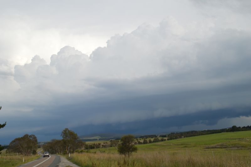
3 - Sunday 25 August (Mainly Victoria and Southern inland New South Wales)
Strong and fast moving thunderstorms developed across parts of Victoria following an unusually warm August day ahead of a strong cold front. A few storm cells certainly reached into the severe range and severe thunderstorm warnings were issued as required. I am aware of the following main events:
Puckapunyal West - A thunderstorm between 3.41 pm and 4.30 pm dropped 19.8 mm with a peak wind gust of 59 km/h at 4.05 pm. This included 6.8 mm of heavy rainfall between 4 pm and 4.05 pm (Certainly unusual for August and for Victoria).
Mangalore - A thunderstorm produced a peak wind gust of 57 km/h at 4.30 pm.
Melbourne (City) - A peak wind gust of 78 km/h occurred at 11.24 am.
Mt Gelibrand - A peak wind gust to 87 km/h occurred at 3.38 pm.
Bendigo (Central Victoria) - A significant thunderstorm produced 17.8 mm of rain including hail to 3 cm across parts of the city.
Byaduk (Western Victoria) - Hail to 4 cm and up to 5 cm occurred from a thunderstorm.
Kyabram - A separate thunderstorm produced heavy rainfall of 18.2 mm in 28 mm between 4.30 pm and 4.56 pm.
Attached are the Zoom Earth (NASA 2024 images) of the frontal system showing the thunderstorms accompanying the front crossing through Victoria and parts of New South Wales.


4 - August 19 and August 31 (From heat to cold and wind)
A series of strong cold fronts brought significant rainfall to Western Tasmania as well as gale force winds across southern Australia with peak wind gusts exceeding 100 km/h at numerous locations. In addition:
On August 30, parts of Sydney reached 30C including 30.3C at Observatory Hill. It is believed that this is only the third time ever (Since records commenced in 1858) that a 30C day has been recorded at Observatory Hill (Sydney) for August with the last such day occurring on Thursday August 31 1995. On this day, it reached 30.5C at Observatory Hill. It must be qualified that 30C was not reached at locations such as Horsley Park where only 29.3C and Holsworthy where 29.8C was reached. It reached 30C at:
- Airport (31.6C).
- Richmond (31C).
- Bankstown (30.5C).
- Penrith and Sydney Olympic Park (30.3C).
- Parramatta (30C).
- Badgerys Creek (29.9C).
While a series of strong cold fronts crossed southern Australia, an unusual inland heatwave occurred mainly impacting desert and remote areas.
During this event, a new maximum temperature record for August occurred at Yampi Sound in Western Australia’s Kimberley region where 41.6c was recorded after 3.30 pm on Monday 26 August.
On Tuesday August 27, it reached 39.2C at Broome (Western Australia) exceeding the previous August record of 38.9C of 2022. Further, it reached 40.5C at Broome on Wednesday August 28 making this the first time ever that 40C has been reached at Broome.
Prior to this, 40C had only occurred 4 times in Australia during winter (Weatherzone August 2024).
Coming back from Indonesia, we flew over this region and it is clear that there had been a heatwave. At sunrise, a high amount of dust was visible within the lower atmosphere and even the occasional grassfire was observed from 11,887 metres (Cruising altitude of the aircraft).
On Wednesday August 28, significant and gale force winds impacted 4 states as strong cold fronts passed across southern Australia. Some significant wind gusts included but not limited to:
Tasmania
Mount Read (North west Tasmania) - A peak wind gust to 156 km/h occurred.
Kunanyi (Mt Wellington) - A peak wind gust to 143 km/h occurred at 8.48 am.
Victoria
Mt Buller - A peak wind gust to 128 km/h occurred at 2.48 am.
Cape Otway - A peak wind gust to 124 km/h occurred at 4.24 am.
New South Wales
Thredbo Top Station - A peak wind gust to 128 km/h occurred.
Port Kembla - A peak wind gust to 104 km/h occurred after 11 am.
Sydney (Observatory Hill) - A peak wind gust to 87 km/h occurred at 5.07 pm.
Tasmania Saturday August 31
Some significant and powerful peak wind gusts from another strong cold front included:
- Launceston - A peak wind gust to 94 km/h occurred at 7.58 pm.
- Devonport - A peak wind gust to 109 km/h occurred at 3.40 am Friday August 30 plus another peak gust to 104 km/h occurred at 4.04 pm on the 31.
- Cape Sorell - A peak wind gust to 117 km/h occurred at 6.06 pm.
- Dennes Point - A peak wind gust to 143 km/h occurred at 7.09 pm.
- Scotts Peak Dam - A peak wind gust at 161 km/h occurred at 6.15 pm.
- Hartz Mountains - A peak wind gust to 163 km/h occurred at 6.29 pm.
- Kunanyi (Mount Wellington) - A peak wind gust to 172 km/h occurred at 7.20 pm.
In addition to the peak wind gusts, heavy rainfall and snow at higher elevations have resulted in flooding of rivers across the Western regions of the state.
A major cleanup is underway across the worst affected areas.
Attached is the accumulative August rainfall plot for the whole of Tasmania (BOM Water and the Land dated Saturday 7 September 2024) and it shows that rainfall across the western half of the island state topped 200 to 600 mm for the month. The eastern third received much lower totals due to the areas being on the lee side of the mountain ranges. The series of fronts and associated rain events have eased drought or serious rainfall deficiencies that were enveloping the region.

I have noticed that as a result of the recent winds and gales, numerous trees have been blown down. I had to travel to Batemans Bay and back Thursday 5 September and noted that several large trees that had fallen across roads had been lopped back as part of cleanup and recovery efforts to maintain road access between towns.
In conclusion, compared to the benign weather that I experienced in Jogjakarta throughout August, the month has been a period of wide extremes across Australia and vastly different to what I encountered.