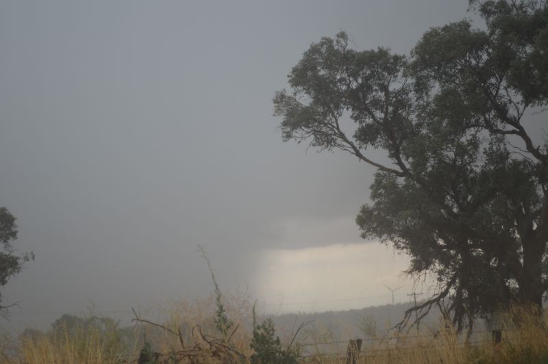
A rare weather event has unfolded across southern Australia over recent days in which three separate rain bands formed and impacted much of the southern Murray Darling Basin.
This was the region that experienced near drought like conditions for the past two years and obviously, this event is certainly welcome.
A series of frontal systems and a north west airstream ahead of the strongest cold front is responsible for the weather event.
The key to this event and its unusual behaviour was:
1 – The first rain band passed over on Monday and Tuesday 29 and 30 June 2026 delivering widespread rainfall. The heaviest rainfall fell across western Victoria and western parts of New South Wales and south east South Australia.
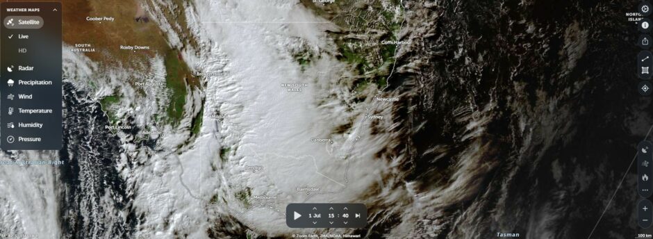
2 – The second rain band passed over on Wednesday 1 July 2026 which brought some solid rainfall totals to south west New South Wales and north east Victoria.
3 – The third rain band that passed over the same regions on Thursday 2 July was accompanied with the main cold front and with it, the coldest airmass behind it. This was the front that brought the first significant snowfall of the season to the higher peaks of the Snowy Mountains and the peaks of northeast Victoria being falls of 20 to 30 cm at best.
The weather system displayed some interesting phenomena as follows:
- The heaviest rainfall (The accumulative totals exceeding 100 mm) fell within a narrow band within the northern side of the Great Dividing Range of Victoria and the western side of the Great Dividing Range within southern New South Wales.
- Serious rain shadows existed on the southern and eastern sides of the Great Dividing Range. While northern Victoria enjoyed solid totals, very little rainfall penetrated into the New South Wales South Coast or Gippsland region of Victoria. All the runoff has flowed into the southern Murray Darling Basin.
- The rain bands trained over the same regions. The cloud masses formed over South Australia then tracked south eastward over New South Wales and Victoria.
- Following the event of Wednesday 1 July, 2026, minor flooding was observed along some rivers of northeast Victoria such as the Ovens River and Kiewa River.
- Isolated daily single totals topped 50 mm at a few locations during the events such as 51.4 mm at Mt Hope (Western New South Wales) on the 2 July and 67.2 mm falling at Specimen Hill Reservoir on Bendigo’s western outskirts (Central Victoria) on June 30.
- A thunderstorm passed over Adelaide early Wednesday morning with at least 50,000 lightning strikes being tracked during a 12 hour period to 9.30 am Wednesday morning.
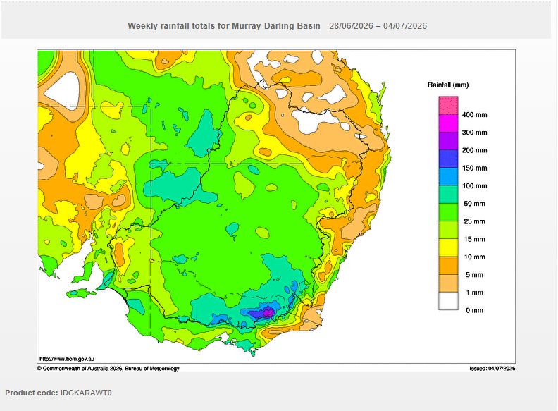
Some of the heavier rainfall totals being the cumulative 7 day totals to 9am Saturday morning) are:
1 – New South Wales
The event was largely centred on the southern Murray Darling Basin including:
- Ivanhoe Airport – 38.2 mm.
- Wagga Wagga (AMO) – 46 mm.
- West Wyalong Airport – 57.8 mm.
- White Cliffs – 59.6 mm.
- Albury Airport – 62 mm.
- Thredbo Village – 182 mm.
2 – South Australia
The rainfall was largely centred across the south east including Adelaide city region.
- Burnside – 62 mm.
- West Terrace – 63 mm.
- Belair (State Flora Nursey) – 76 mm.
- Aldgate – 103.8 mm.
- Ashton – 104.6 mm.
Much of Adelaide experienced 50 mm plus cumulative totals with 100 mm cumulative totals falling within the Adelaid Hills to the east of the city.
3 – Tasmania
The weather event impacted much of northern Tasmania with rain shadows existing across southern areas. The best falls were within the northern areas including:
- Devonport Airport – 85.2 mm.
- Burnie – 104.2 mm.
- Mt Arthur Summit – 122.
- Railton (Dowliggin Street) – 139.8 mm.
- Loongana (Serendipity) – 141 mm.
4 – Victoria
- Mt Nowa Nowa (On southern side of the Great Dividing Range towards Gippsland – 5.2 mm to showcase the massive rain shadow effect).
- Ballarat – 45 mm.
- Echuca – 49 mm.
- Lorne – 63.2 mm.
- Avoca – 63.6 mm.
- Wodonga – 69.4 mm.
- Bendigo Airport – 90.4 mm.
- Blackwood – 95.9 mm.
- Daylesford – 108.6 mm.
- Hunters Hill – 111.4 mm.
- Dederang – 130.6 mm.
- Overns River at Harrietville – 149.2 mm.
- Mt Hotham – 150 mm.
- Falls Creek – 177 mm.
- Hals (Buckland River) – 178 mm.
- Archerton – 207 mm.
The image (NASA Zoom Earth 2026) attached is showing the cloud mass associated with the second rain band crossing through the Murray Darling Basin during Wednesday 1 July 2026.