An incredible tropical cyclone has finally concluded its journey after making landfall 3 times across northern Australia.
After making landfall across the Cape York Peninsula (Queensland) a week ago, the system passed back over the sea over the Gulf of Carpentaria only to make landfall again south of Nhulunbuy (Northern Territory) as a weaker storm.
While the tropical cyclone weakened to a tropical storm, the low pressure system remained intact as it crossed over the base of the Top End of the Northern Territory passing close to the towns of Katherine and Wadeye.
The system then crossed over the northern tip of the Kimberley near Kalumburu and went back out to sea. The storm re intensified and reached tropical cyclone status again as it tracked southwest.
Models initially suggested that the storm would then track away from Australia as a stronger storm system travelling in a general westerly direction with a slight south westerly track included. However, this did not occur.
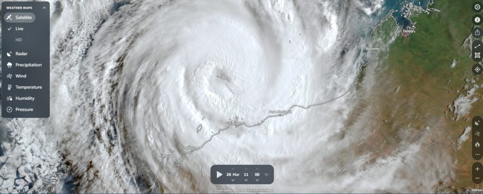
Instead, the storm took a more south westerly track that brought it closer to the Western Australia coastline. As such between Tuesday and Friday, the storm brushed the Western Australia coastline only to turn south and make landfall near Onslow and Learmonth.
The storm finally broke down as it crossed the coast. This means that the tropical cyclone made landfall three times across different parts of northern Australia which is amazing and a rarity. Only one other storm system has achieved this feat being Tropical Cyclone Ingrid of March 2005.
According to CIMSS, the storm reached a Category 4 system on the Saffir Simpson Scale at landfall. As such, this was a strong storm.
It is noted that under the Australian Tropical Cyclone Intensity Scale of 1989, the storm also peaked at Category 4 with peak wind gusts calculated to be 205 km/h.
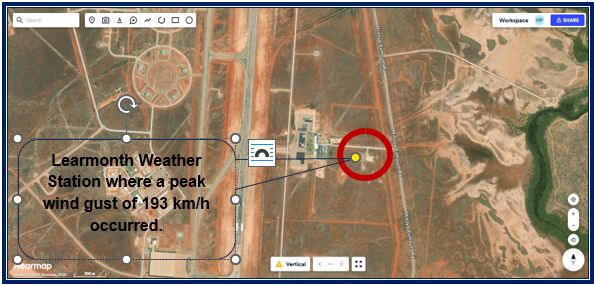
Unlike the landfall over Queensland which occurred over an area generally lacking weather stations, a good account of peak wind gusts are available over the region impacted. This occurred because the storm passed over enough weather stations and thus a solid account of what occurred is available.
As such, estimated peak wind gusts of 205 km/h at peak intensity almost aligns with a peak wind gust of 193 km/h at Learmonth Airport at 6 am Friday morning. A near accurate account of the storm at peak intensity can be made.
During its travel over Northern Territory and Western Australia, the following observations are available:
Northern Territory
- Bullman – 117 mm to 9 am Sunday (Rain).
- Gove Airport – 130.8 mm to 9 am Sunday plus a peak wind gust to 98 km/h at 11 pm Saturday (Rain and wind).
- Groote Eylandt Island – A peak wind gust to 78 km/h as the storm weakened during its second landfall (Wind).
- Ngayawili (Echo Island) – A peak wind gust to 83 km/h (Wind).
Rainfall to 9 am Monday morning
- Adelaide River – 195 mm.
- Upper Adelaide River – 170.6 mm.
- Central Arnhem Plateau – 169 mm.
- Port Keats – 118 mm.
- Katherine River – Moderate flooding due to the amount of rainfall across the upper catchments. Second flood this month.
Western Australia
- Barrow Island – Peak wind gust to 154 km/h late Friday evening. (Wind).
- Bedout Island – Peak wind gust to 132 km/h Wednesday evening (Wind).
- Rowley Shoals – Peak wind gust to 145 km/h. It appears that the edge of the eyewall passed over the weather station as 100 km/h plus wind gusts dropped to 11 km/h at 2.30 pm Wednesday (Wind).
- Carnarvon – A peak wind gust to 132 km/h at 3.40 pm Friday (Wind).
- Karratha – Peak wind gust to 122 km/h (Wind).
- Learmonth Airport – A peak wind gust to 193 km/h at 6 am Friday morning plus other wind gusts above 170 to 190 km/h also recorded. This includes 231.4 mm of rain to 9 am Friday morning plus another 116.6 mm to 3.30 pm. It is noted that the radar is down and the weather station is currently not operational probably due to a power cut. It would appear Learmouth is hard hit (Rain and wind).
- Onslow – A peak wind gust to 150 km/h at 1.29 to 130 am Friday morning (Wind).
Rainfall to 9 am Saturday morning
- Barrow Island Airport – 208 mm.
- Thevenard Island – 196.6 mm.
- Varanus Island – 181 mm.
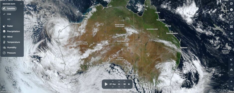
The storm has ended its life span but is now spreading rainfall along the west Australian coastline. As such, solid 60 to 90 mm rainfalls have impacted Perth and towns further to the south which at the time of writing is still an ongoing event.
Note: The feature image taken during an intense thunderstorm is not of Tropical Cyclone Narelle but it provides some idea of what was occurring across the region specific to intense rain and wind at landfall.