A developing weather system across the northwest of Western Australia is gaining interest because it has potential to produce a significant rain event across large swathes of the continent over coming days.
Initially, the developing low pressure cell is expected to produce widespread rain / showers and even thunderstorms across remote and desert regions of Western Australia and Northern Territory where widespread 25 to 50 mm falls are anticipated. Higher rainfall totals in some desert regions cannot be ruled out and there is even the prospect of isolated flooding occurring.
Initially, the system will be impacting mainly outback regions where there are few towns and road access.
However, there is interest in this system as longer run models are suggesting that the system will track southeast into New South Wales, Victoria and the ACT (Canberra). It would appear that at this stage, Queensland will not be impacted by this system.

Models are constantly changing and thus what is stated here is likely to change as Wednesday to Friday 25 to the 27 September approaches. However, there seems to be some common ground emerging as various models are considered as follows:
- Much of New South Wales and Victoria will be impacted.
- A burst of spring warmth is expected to occur just ahead of this system for New South Wales with the system crossing through southern and central regions of the state during Wednesday. In the case of Sydney, the weather system should arrive across the city during Thursday then continue northwards throughout Thursday and Friday.
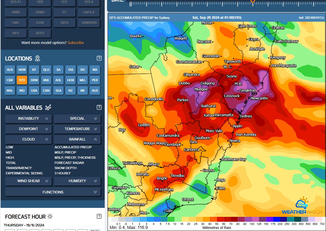
- Expected cumulative rainfall totals would appear to be healthy with falls of 40 to 50 mm extending from northeast Victoria, through Albury then northwards towards Tamworth.
Some of the southern border areas of New South Wales are close to drought conditions following a dry autumn and winter. This event would be most welcome by farmers to ease developing water shortages.

It would also appear that heavier rainfall totals are possible within an area from Sydney northwards to Port Macquarie then west to Mudgee where various models are suggesting 50 mm to 90 mm to fall. This is an area to watch over coming days.
What is certain is that the current dry period is expected to be broken. To show this, I have not experienced or seen rain for 50 days (Since Friday 2 August) and this event will be a welcome change to the current weather pattern of sunny days with little or no cloud.
I will be on the New South Wales North Coast during Thursday and Friday during the later part of the period and given that the heaviest rainfall is possible within these areas, there is potential for photos to be taken should there be local flooding.

For New South Wales, while there is the potential for thunderstorm activity, it would appear at this stage that any storm activity would be embedded within the rain. For the most part, this would appear to be a general widespread rain event rather than an outbreak of significant thunderstorms across the state.
I have attached various models suggesting this event using the GFS. As the event approaches what is seen on the rainfall plots is expected to change.