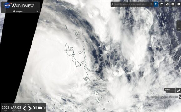
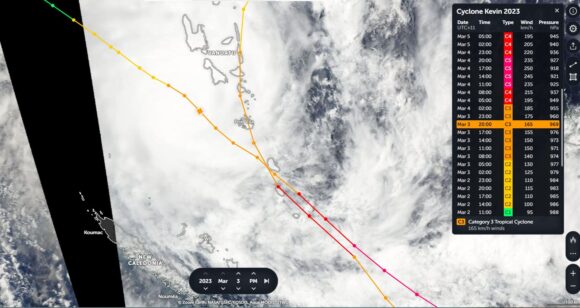
Using Zoom Earth which is a combination of NASA / GFSC / EOSDIS on the Aqua / MODIS satellite and adding in the overlays, a remarkable picture can be ascertained of what occurred across Vanuatu between Wednesday March 1 and Saturday March 4 2023.
Two strong tropical cyclones struck the island chain and using the overlays, it can be shown that both storms took similar paths as they traversed the island chain. Both reached Category 3 or 4 on the Saffir Simpson Scale (Category 4 or 5 using the Australian Tropical Cyclone Intensity Scale of 1989).
Both storms have caused significant destruction including flooding. This also came at a time when the island chain experienced two moderate to strong earthquakes during the same period.
Tropical Cyclone 1 - Tropical Cyclone Judy
The first tropical cyclone named Judy formed north of Vanuatu on Monday 27 February 2023 then tracked direct south over Vanuatu during Tuesday 28 February and Wednesday 1 March 2023. The storm continued to gain strength as it passed across the island chain reaching Category 4 (Australian Tropical Cyclone Intensity Scale) but Category 3 on the Saffir Simpson Scale just to the south of the island of Erromango. At this stage, the storm also passed over the island of Tanna and had sustained peak wind gusts to 185 and 195 km/h at the core.

The storm had reached peak intensity at a mid range Category 3 system (Saffir Simpson Scale) but mid range Category 4 system using the Australian Tropical Cyclone Intensity Scale. This was only sustained for 1 day. The storm went into decline after Friday 3 March 2023 as it travelled further south over colder waters.
Tropical Cyclone 2 - Tropical Cyclone Kevin
The second storm was the stronger of the two storms with the storm even sustaining Category 5 (Australian Tropical Cyclone Intensity Scale) (High end Category 4 storm under the Saffir Simpson Scale) status during Saturday March 4 2023 at least for a period of 11 hours.
The storm formed off the coast of Queensland and tracked further east towards the southern half of the Vanuatu island chain and strengthening.
The storm passed to the west and south of Port Villa reaching Category 3 (Australian Tropical Cyclone Intensity Scale) Category 2 (Saffir Simpson Scale) and sustaining winds to 160 km/h. On Saturday, March 4 2023, the storm had crossed the path and took a similar path to that of Tropical Cyclone Judy did for the next 12 hours. The storm reached peak intensity as a Category 5 storm (Australian Tropical Cyclone Intensity Scale) and a high end Category 4 system under the Saffir Simpson Scale with peak wind gusts to 250 km/h. During the next two 2 days, the storm went into gradual decline as it tracked over colder oceanic waters south of the tropics.

Both storms have caused considerable damage across the island chain and recovery efforts will be slow and difficult given the scale of the disasters that have occurred.
I have attached the NASA (EOSDIS) Worldview image of both tropical cyclones and a “Zoom Earth” (Storms) overlay showing Tropical Cyclone Kevin plus the overlaid travel paths for both storms as they traversed the island chain.

