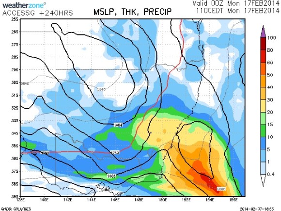
 The Bureau of Metegology 10 Day model has now indicated rain about the 16th to 17th February 2014 period. Monitoring cloesly and it seems that the rain band may originate from southern Western Australia with the break down of the tropical low system that is likely to develop next week.
It s not the first time that rainfall has occurred at this time year but ths event is the best chance being progged by the models thus far. About two days ago, the GFS model attempted to place heavy rainfall at slightly latter period.
Until then, southern Australia will ensure very warm to hot conditions and in the case of this weekend dangerous bushfire conditions with the relentless drought, hot day and night conditions dramatically increasing fire danger levels. Victorians who lived through the 1983 Ash Wednesday bushfires would be quite aware of what can happen in February let alone Black Saturday.

Heat for Victoria and let's hope rain is in sight sooner than later.
Hi Jimmy, its starting to look like the relentless high pressure systems that have plagued us will finally down from next Friday and allow a period of low pressure to dominate over the south east as is more typical for this time of year. I like that GFS is still holding a chance for the monsoonal low to collide with a polar low over southern Australia next weekend. If that does occur and the interaction is close to the mainland we could see some substantial rainfall throughout victoria and Tasmania.
Now that will be a change Jeff! And yes I have been monitoring the concept of the cooler polar air mass interacting with the subtropical systems to produce a substantial rain event. A little far out but it is still worth being monitored given that the models are now onto something daily.
Meanwhile, eastern parts of South Australia endured extreme fire conditions including a catastrophic fire level with dangerous blazes in the Mt Lofty Ranges.
I am finally seeing evidence of a break down in the high pressure belt late in the week. A rain event is badly needed over a wide area. I was in south west NSW some three weeks ago and I was stunned to see how dry it was including areas where the grass had turned yellow. The incesant heat and dry has taken its toll not to mention the fires. I passed at least five blazes during my travels with one forcing a detour.
Only looking at Weatherzone at this stage, it appears that the NE and Eastern districts of Victoria are in line for at least 20 mm and even 30 mm with lower totals across the western half and north west of the state.
It also appears that this will spill over into Eastern NSW as well. Whatever happens it should be enough to break the dome of heat afflicting the inland regions.
Jeff, I was l looking for some form of interaction as an ideal way to beak tho dry hot pattern.