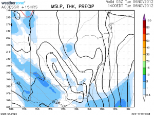
 Following the massive lightning show in South Australia yesterday with 126,000 lightning strikes reported on the lightning tracker network, more storms are expected over the coming days beginning from today. Given the amount of heating, there is the chance of storms to once again develop across the inland and perhaps along the coastal strip of NSW today. Some storms may be severe but the most likely scenario will be higher based storms with lightning and strong winds. Some rain will develop across the inland as a meso-low develops. Along the coastal strip, the moist NE winds will pump inland and if they can reach the bases may assist in some development along the ranges from Bombala through to near Sydney.

6 thought on “Storms for NSW 6th November 2012 following 126,000 lightning strikes for South Australia”
Leave a Reply
You must be logged in to post a comment.
I think the models look better for tomorrow and the next day as an upper level trough approaches from the west. Hopefully there's not too much cloud cover and we get some moisture inflow. Maybe still some chance Sydney will get a light show tomorrow night.
It seems the atmosphere around Sydney is heavily capped with cumulus now flattening out into altocumulus.
I undertook a chase today and after discussing the weather with Jimmy, I proceeded to Goulburn and Marulan to find out what would occur. I did not go any further. At Goulburn, I did some weather checks and soundings and identified that while initial forecasts suggested the region around Wagga Wagga would experience thunderstorms, I found that the dew points were low and thick cloud impacted the area. So far, there have been no storms in that area. At Goulburn, I observed clusters of cumulus clouds forming along a boundary to the east. I drove back to Marulan to observe the cumulus clouds. However thicker cirrus stratus cloud eventually overtook that area which ended any chance of further convection. I also noted how dry the WNW winds were. Around 3 pm, I left after spotting a very isolated shower cell around Mittagong to the north east. I drove towards it and discovered that it was not significant. I returned back to Sydney.
As I write this a narrow band of light showers are crossing through the Goulburn region but no storms. I found the boundaries and some areas of heating but I noted the dry NW winds did not help and neither did the cloud band further to the west. I observed one cumulus tower approach the congestus stage but that quickly collapsed. I took no photos. At least I did not venture too far from Sydney.
Hi Harley Pearman, yes it was a tough day. You get the day off and the models don't agree on the day! The Bureau model suggested upper level warming and I guess GFS has ample mid-level cloud. I targeted the same region but thanks to your guidance I did not head down there and remained home!
Meanwhile in the middle of the country…. there’s been a strong cell on Alice Springs radar moving east ahead of the approaching squall line or bow echo from the SW. It’s still active now at 8pm EDT
You are correct Murray John, I feel tomorrow is going to be a better day but there will be more substantial rainfall as well. I feel the region just behind the rain band and perhaps feeding the developing rain band provides the best chances of storms and severe storms.