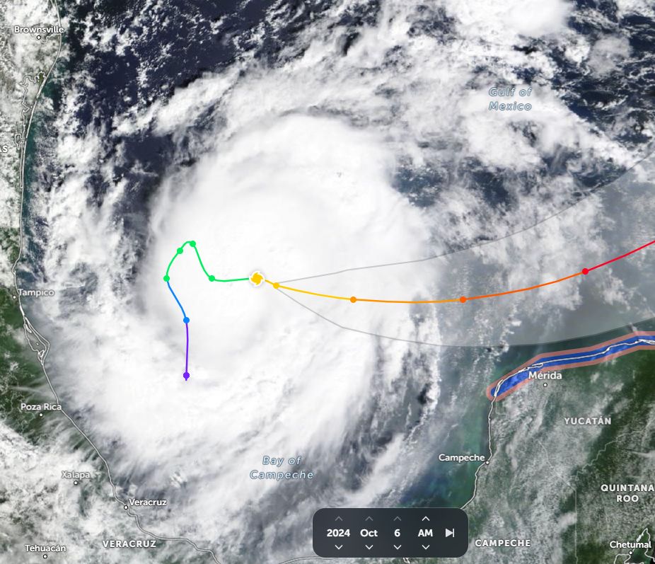
As expected, a second major hurricane is currently in the process of forming within the Gulf of Mexico. The named storm known as Milton has just reached hurricane intensity and at the time of writing, appears to have sustained winds at the core of 85 miles per hour (137 km/h). This would make it a Category 1 storm on the Saffir Simpson Scale.

Forecast models are suggesting landfall along the west coast of Florida within the next 3 days near or potentially over the major city of Tampa / St Petersburg. However careful modelling at the present time suggests landfall just to the south of the city being the City of Sarasota.
Either way, a major metropolitan region comprising of several cities with a combined regional population of slightly more than 4 million lies within the expected landfall area and as such, great attention is being paid to the storm.
The storm is of critical concern given what occurred ten days ago to areas to the north following Hurricane Helene. The cleanup from that storm has barely begun and to date:
- The death toll continues to rise with now 227 fatalities confirmed. This is still rising.
- The damage bill already exceeds a minimum of $30 billion which continues to rise as more areas are reached by rescue crews.
- The cleanup from that storm has barely begun and thus emergency crews are focused on the aftermath of that event.
The new storm will exacerbate a delicate situation and create new emergencies within a state that is still struggling with the aftermath of the first hurricane. Evacuations associated with the new storm will be a challenge. If the forecast models are correct and landfall does occur over a major city, then the aftermath of this will be of great concern. To date:
- Forecast models show a major hurricane while out over the Gulf of Mexico reaching at least Category 4 on the Saffir Simpson Scale and potential landfall as a Category 3 storm. This could change as the storm has already exceeded certain forecast expectations.
- CIMSS models currently suggest a storm with peak winds at Category 4 of 125 knots (228 km/h at peak strength).
- The storm is forming over waters heated to 29C with some waters within vicinity of the landfall region heated to 30C.
The Gulf of Mexico is a very large body of water which is surrounded by land masses on three sides. The Gulf of Mexico is capable of supporting such storms due to the level of heating that occurs every summer. Thus, the land masses along the edges of the Gulf are prone to such storms every year.
- Satellite photos show solid convection and a compact storm but at the time of writing, no verified eye exists. It would be expected that an eye will form in due course.
- The storm is forecast to track NE towards the west coast of Florida.
Unlike Hurricane Helene which make landfall over a small town called Perry, the landfall of Milton could be very different.
Sarasota city Florida
The images attached are derived from Google Earth Experimental.
Sarasota (Florida) is a low lying city and there are residential subdivisions very close to the edge of the seashore and sandy beaches. The city centre is also low lying. Additionally, there are canal estates within areas that are susceptible to flooding and storm surge.
Population - 765,000 (2024 estimates).

Tampa / St Petersburg Florida
Similar development has occurred at Tampa and St Petersburg to the north and it is known that the highest point of Tampa City is not much more than 15 metres above sea level.
Population - 3,300,000 (2024 estimates).

Storm surge maps
Besides the usual wind and heavy flooding rains that the storm is expected to produce, the principal concern here would be the storm surge generated by the storm. The storm surge could become a critical issue exacerbating property damage across affected canal estates. The National Weather Service has published storm surge maps as part of the forecast models being prepared suggesting that this is going to be a serious issue for the low lying areas as the storm comes ashore.

Given the level of urban development across this part of Florida, the storm does have potential to become a second costly and significant weather event for the state of Florida.


I have attached as part of the post:
- CIMSS Forecast Model as it currently stands for Sunday 6 October 2024.
- NASA (Zoom Earth of the storm) - Immediately after formation and after being declared a formal hurricane (For the Feature Image).
- National Weather Service Storm surge map for Sarasota City.
- The Day 3 early forecast model for Florida Rainfall plot (National Weather Service).
- National Weather Service Band 7 GOES Image and accompanying satellite picture.
- Google Earth Experimental - Images of Sarasota and Tampa cities showing the level of development at the location where landfall is being forecast.